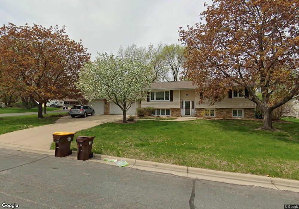
11604 Ravoux Ave Burnsville, MN 55337
Estimated Value: $386,806 - $433,000
3
Beds
2
Baths
1,182
Sq Ft
$350/Sq Ft
Est. Value
About This Home
This home is located at 11604 Ravoux Ave, Burnsville, MN 55337 and is currently estimated at $413,952, approximately $350 per square foot. 11604 Ravoux Ave is a home located in Dakota County with nearby schools including William Byrne Elementary School, Burnsville High School, and Gateway STEM Academy.
Ownership History
Date
Name
Owned For
Owner Type
Purchase Details
Closed on
Sep 1, 2020
Sold by
Mcdonnell Peter T and Mcdonnell Helen D
Bought by
Benhardt Steven Michael and Benhardt Jennifer Marie
Current Estimated Value
Home Financials for this Owner
Home Financials are based on the most recent Mortgage that was taken out on this home.
Original Mortgage
$310,650
Outstanding Balance
$275,681
Interest Rate
2.9%
Mortgage Type
New Conventional
Estimated Equity
$138,271
Create a Home Valuation Report for This Property
The Home Valuation Report is an in-depth analysis detailing your home's value as well as a comparison with similar homes in the area
Home Values in the Area
Average Home Value in this Area
Purchase History
| Date | Buyer | Sale Price | Title Company |
|---|---|---|---|
| Benhardt Steven Michael | $327,000 | Trademark Title Services Inc |
Source: Public Records
Mortgage History
| Date | Status | Borrower | Loan Amount |
|---|---|---|---|
| Open | Benhardt Steven Michael | $310,650 |
Source: Public Records
Tax History Compared to Growth
Tax History
| Year | Tax Paid | Tax Assessment Tax Assessment Total Assessment is a certain percentage of the fair market value that is determined by local assessors to be the total taxable value of land and additions on the property. | Land | Improvement |
|---|---|---|---|---|
| 2024 | $3,876 | $365,600 | $83,900 | $281,700 |
| 2023 | $3,876 | $371,200 | $83,900 | $287,300 |
| 2022 | $3,252 | $363,300 | $83,700 | $279,600 |
| 2021 | $3,300 | $309,600 | $72,800 | $236,800 |
| 2020 | $3,254 | $298,600 | $69,300 | $229,300 |
| 2019 | $3,134 | $284,900 | $66,000 | $218,900 |
| 2018 | $3,049 | $263,000 | $62,900 | $200,100 |
| 2017 | $2,819 | $249,500 | $59,900 | $189,600 |
| 2016 | $2,943 | $229,200 | $57,100 | $172,100 |
| 2015 | $2,747 | $212,806 | $51,393 | $161,413 |
| 2014 | -- | $207,247 | $50,264 | $156,983 |
| 2013 | -- | $180,106 | $44,981 | $135,125 |
Source: Public Records
Map
Nearby Homes
- 3017 Mcleod St
- 11459 Galtier Dr
- 4427 Cinnamon Ridge Cir
- 4425 Cinnamon Ridge Cir
- 4463 Cinnamon Ridge Cir
- 4413 Slater Rd
- 11902 River Hills Cir
- 3309 Red Oak Cir N
- 4632 Westwood Ln
- 11921 Baypoint Dr
- 11900 Highland View Cir
- 11036 27th Ave S
- 10934 Southview Dr
- 11017 27th Ave S
- 2200 Horizon Rd
- 4774 Slater Rd
- 4370 Nicols Rd
- 2123 Cliffhill Ln
- 11115 Carver Ct
- 319 River Woods Ln
- 11600 Ravoux Ave
- 11606 Ravoux Ct
- 11605 Ravoux Ave
- 11612 Ravoux Ave
- 11609 Ravoux Ave
- 11520 Ravoux Ave
- 11601 Ravoux Ave
- 11613 Ravoux Ave
- 11608 Ravoux Ct
- 11610 Ravoux Ct
- 11521 Ravoux Ave
- 11617 Ravoux Ave
- 11517 Ravoux Ave
- 11516 Ravoux Ave
- 11529 River Hills Dr
- 11525 River Hills Dr
- 11616 Galtier Dr
- 11620 Galtier Dr
- 11533 River Hills Dr
- 11612 Galtier Dr