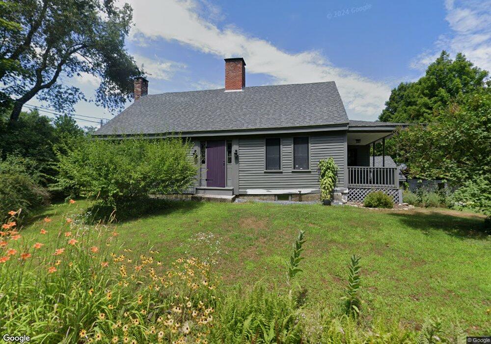
1164 1st Crown Point Rd Strafford, NH 03884
Estimated Value: $478,501 - $597,000
3
Beds
1
Bath
2,021
Sq Ft
$267/Sq Ft
Est. Value
About This Home
This home is located at 1164 1st Crown Point Rd, Strafford, NH 03884 and is currently estimated at $538,875, approximately $266 per square foot. 1164 1st Crown Point Rd is a home located in Strafford County with nearby schools including Strafford School and Coe-Brown Northwood Academy.
Ownership History
Date
Name
Owned For
Owner Type
Purchase Details
Closed on
Feb 4, 2010
Sold by
Lyons Steve E and Lyons Carole J
Bought by
Harrison Thane W and Souriolle Mary E
Current Estimated Value
Home Financials for this Owner
Home Financials are based on the most recent Mortgage that was taken out on this home.
Original Mortgage
$240,712
Interest Rate
5.05%
Mortgage Type
Purchase Money Mortgage
Create a Home Valuation Report for This Property
The Home Valuation Report is an in-depth analysis detailing your home's value as well as a comparison with similar homes in the area
Home Values in the Area
Average Home Value in this Area
Purchase History
| Date | Buyer | Sale Price | Title Company |
|---|---|---|---|
| Harrison Thane W | $242,600 | -- |
Source: Public Records
Mortgage History
| Date | Status | Borrower | Loan Amount |
|---|---|---|---|
| Open | Harrison Thane W | $233,155 | |
| Closed | Harrison Thane W | $240,712 | |
| Previous Owner | Harrison Thane W | $164,500 |
Source: Public Records
Tax History Compared to Growth
Tax History
| Year | Tax Paid | Tax Assessment Tax Assessment Total Assessment is a certain percentage of the fair market value that is determined by local assessors to be the total taxable value of land and additions on the property. | Land | Improvement |
|---|---|---|---|---|
| 2024 | $6,394 | $323,600 | $86,400 | $237,200 |
| 2023 | $6,032 | $323,600 | $86,400 | $237,200 |
| 2022 | $5,543 | $323,600 | $86,400 | $237,200 |
| 2021 | $6,334 | $343,100 | $86,400 | $256,700 |
| 2020 | $5,617 | $219,000 | $80,300 | $138,700 |
| 2019 | $5,140 | $219,000 | $80,300 | $138,700 |
| 2018 | $5,274 | $223,200 | $80,300 | $142,900 |
| 2016 | $4,743 | $223,200 | $80,300 | $142,900 |
| 2015 | $4,674 | $214,300 | $96,000 | $118,300 |
| 2014 | $4,963 | $214,300 | $96,000 | $118,300 |
| 2013 | $5,108 | $225,200 | $96,000 | $129,200 |
| 2012 | $5,040 | $225,200 | $96,000 | $129,200 |
Source: Public Records
Map
Nearby Homes
- 22 Stonewall Dr
- 825 Second Crown Point Rd
- 479 Ten Rod Rd
- 77 Holmes Rd
- 301 Muchado Hill Rd
- 30 Avalon Rd
- 38 Chapelle Rd
- 956 N Barnstead Rd
- 8 King Arthur Dr
- Lot 3 Ridge Rd
- 24 Ragged Mountain Rd
- TBD Merlin Rd
- 00 Squire Rd
- 0 Strafford Rd Unit 5057984
- 42 Trotting Park Rd
- 53 Richards Way
- 152 Evans Rd
- L68-2 Vail Rd
- 163 Central St
- 260 New Rd
- 1164 1st Crown Point Rd
- 1041 First Crown Point Rd
- 1160 1st Crown Point Rd
- 1156 1st Crown Point Rd
- 1179 1st Crown Point Rd
- 1194 1st Crown Point Rd
- 1185 1st Crown Point Rd
- 1191 1st Crown Point Rd
- 1207 1st Crown Point Rd
- 1206 1st Crown Point Rd
- 1225 1st Crown Point Rd
- 1110 1st Crown Point Rd
- 1226 1st Crown Point Rd
- 1226 1st Crown Point Rd
- 1180 1st Crown Point Rd
- 1231 1st Crown Point Rd
- 1238 1st Crown Point Rd
- 1245 1st Crown Point Rd
- 244 Little Niagara Rd
- 1061 1st Crown Point Rd