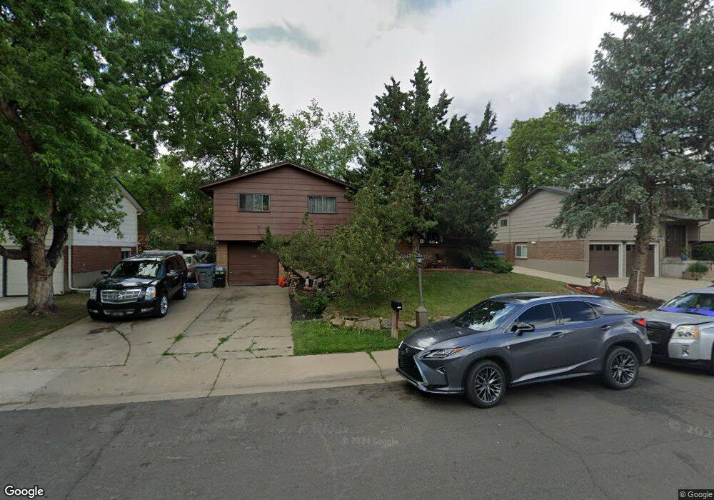
1165 Lefthand Dr Longmont, CO 80501
Southmoor NeighborhoodEstimated Value: $483,195 - $533,000
3
Beds
2
Baths
1,152
Sq Ft
$445/Sq Ft
Est. Value
About This Home
This home is located at 1165 Lefthand Dr, Longmont, CO 80501 and is currently estimated at $512,799, approximately $445 per square foot. 1165 Lefthand Dr is a home located in Boulder County with nearby schools including Burlington Elementary School, Sunset Middle School, and Niwot High School.
Ownership History
Date
Name
Owned For
Owner Type
Purchase Details
Closed on
Mar 8, 2011
Sold by
The Chung Mo Chan Living Trust
Bought by
The Chung Mo Chan 2010 Family Trust
Current Estimated Value
Purchase Details
Closed on
Jul 18, 1996
Sold by
Chan Chung Mo and Chan Barbara H
Bought by
Chan Barbara H and Barbara H Chan Living Trust
Purchase Details
Closed on
Feb 28, 1995
Sold by
Knutsen Douglas and Knutsen Denise K
Bought by
Chan Chung No
Create a Home Valuation Report for This Property
The Home Valuation Report is an in-depth analysis detailing your home's value as well as a comparison with similar homes in the area
Home Values in the Area
Average Home Value in this Area
Purchase History
| Date | Buyer | Sale Price | Title Company |
|---|---|---|---|
| The Chung Mo Chan 2010 Family Trust | -- | None Available | |
| Chan Barbara H | -- | -- | |
| Chan Chung Mo | -- | -- | |
| Chan Chung No | $100,000 | -- |
Source: Public Records
Tax History Compared to Growth
Tax History
| Year | Tax Paid | Tax Assessment Tax Assessment Total Assessment is a certain percentage of the fair market value that is determined by local assessors to be the total taxable value of land and additions on the property. | Land | Improvement |
|---|---|---|---|---|
| 2025 | $2,651 | $28,562 | $13,506 | $15,056 |
| 2024 | $2,651 | $28,562 | $13,506 | $15,056 |
| 2023 | $2,615 | $27,711 | $16,830 | $14,566 |
| 2022 | $2,362 | $23,866 | $11,926 | $11,940 |
| 2021 | $2,392 | $24,553 | $12,269 | $12,284 |
| 2020 | $2,170 | $22,337 | $9,724 | $12,613 |
| 2019 | $2,136 | $22,337 | $9,724 | $12,613 |
| 2018 | $1,846 | $19,433 | $6,984 | $12,449 |
| 2017 | $1,821 | $21,484 | $7,721 | $13,763 |
| 2016 | $1,618 | $16,923 | $7,403 | $9,520 |
| 2015 | $1,541 | $14,901 | $5,015 | $9,886 |
| 2014 | $1,392 | $14,901 | $5,015 | $9,886 |
Source: Public Records
Map
Nearby Homes
- 1350 S Lincoln St
- 1435 Ashcroft Dr
- 1801 S Pratt Pkwy
- 1327 Brookfield Dr
- 1435 Missouri Ave
- 1028 Katy Ln
- 919 S Sherman St
- 1072 Kane Dr
- 1328 S Terry St
- 1527 S Vivian St
- 1456 Sepia Ave
- 1343 S Coffman St
- 9 Seattle Ln
- 1518 Sepia Ave
- 1208 S Coffman St
- 2030 Emerald Dr
- 832 S Bowen St
- 802 Neon Forest Cir
- 2050 Emerald Dr
- 740 Satisfaction Cir
- 1159 Lefthand Dr
- 1171 Lefthand Dr
- 1153 Lefthand Dr
- 1348 S Bowen St
- 1160 Lefthand Dr
- 1154 Lefthand Dr
- 1147 Lefthand Dr
- 1207 Lefthand Dr
- 1148 Lefthand Dr
- 1342 S Bowen St
- 1402 S Bowen St
- 1141 Lefthand Dr
- 1206 Lefthand Dr
- 1225 Missouri Ave
- 1213 Lefthand Dr
- 1142 Lefthand Dr
- 1219 Missouri Ave
- 1157 Avon Ln
- 1161 Avon Ln
- 1135 Lefthand Dr