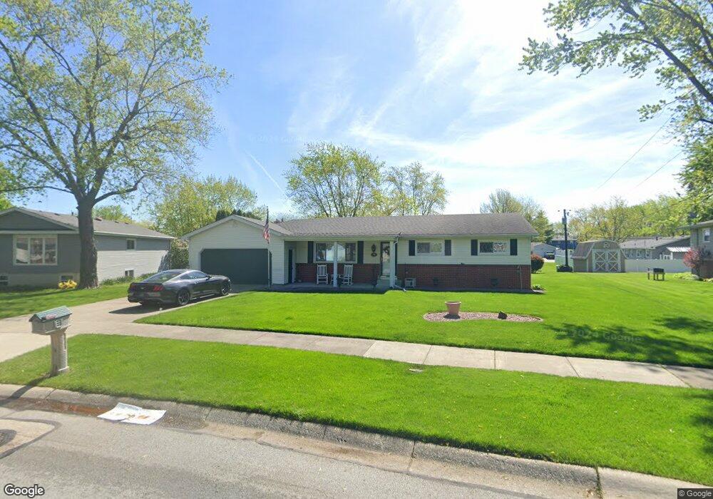
1166 Pettibone St Crown Point, IN 46307
Estimated Value: $294,000 - $321,000
3
Beds
2
Baths
1,486
Sq Ft
$207/Sq Ft
Est. Value
About This Home
This home is located at 1166 Pettibone St, Crown Point, IN 46307 and is currently estimated at $306,892, approximately $206 per square foot. 1166 Pettibone St is a home located in Lake County with nearby schools including Dwight D. Eisenhower Elementary School, Robert Taft Middle School, and Crown Point High School.
Ownership History
Date
Name
Owned For
Owner Type
Purchase Details
Closed on
Apr 26, 2024
Sold by
Bencie Mark L
Bought by
Bencie Joshua L
Current Estimated Value
Purchase Details
Closed on
Feb 16, 2022
Sold by
Bencie Land Trust and Bencie Mark L
Bought by
Bencie Mark L
Purchase Details
Closed on
Mar 24, 2006
Sold by
Bencie Louis G and Bencie Dolores Rae
Bought by
Bencie Louis G and Bencie Dolores R
Create a Home Valuation Report for This Property
The Home Valuation Report is an in-depth analysis detailing your home's value as well as a comparison with similar homes in the area
Home Values in the Area
Average Home Value in this Area
Purchase History
| Date | Buyer | Sale Price | Title Company |
|---|---|---|---|
| Bencie Joshua L | -- | None Listed On Document | |
| Bencie Mark L | -- | None Listed On Document | |
| Bencie Louis G | -- | None Available |
Source: Public Records
Tax History Compared to Growth
Tax History
| Year | Tax Paid | Tax Assessment Tax Assessment Total Assessment is a certain percentage of the fair market value that is determined by local assessors to be the total taxable value of land and additions on the property. | Land | Improvement |
|---|---|---|---|---|
| 2024 | $5,034 | $250,100 | $37,400 | $212,700 |
| 2023 | $2,434 | $226,100 | $37,400 | $188,700 |
| 2022 | $2,434 | $220,800 | $37,400 | $183,400 |
| 2021 | $2,282 | $207,300 | $25,100 | $182,200 |
| 2020 | $2,252 | $204,700 | $25,100 | $179,600 |
| 2019 | $2,185 | $194,800 | $25,100 | $169,700 |
| 2018 | $2,347 | $188,200 | $25,100 | $163,100 |
| 2017 | $2,295 | $183,400 | $25,100 | $158,300 |
| 2016 | $2,301 | $181,400 | $25,100 | $156,300 |
| 2014 | $2,034 | $175,200 | $25,100 | $150,100 |
| 2013 | $2,114 | $178,600 | $25,100 | $153,500 |
Source: Public Records
Map
Nearby Homes
- 300 Omega Dr
- 1152 S Ridge St
- 425 Sherwood Dr
- 642 Omega Dr
- 924 W Crestview Ct
- 801 Courtney Dr
- 217 Crestview Ln
- 780 Williams Ct
- 991 Greenview Dr
- 1002 Gordon Ct
- 244 Sawgrass Dr
- 246 Sawgrass Dr
- 248 Sawgrass Dr
- 744 S Court St
- 1191 Churchill Ln
- 622 E Brookside Dr
- 2439 W 127th Ave
- The Ganby Plan at Sawgrass
- The Monarch Plan at Sawgrass
- The Keystone Plan at Sawgrass
- 1144 Pettibone St
- 404 Las Olas Dr
- 1165 Maxwell St
- 1155 Maxwell St
- 1145 Maxwell St
- 1136 Pettibone St
- 1151 Pettibone St
- 312 Las Olas Dr
- 1135 Maxwell St
- 1141 Pettibone St
- 1130 Pettibone St
- 403 Las Olas Dr
- 1125 Maxwell St
- 419 Las Olas Dr
- 1131 Pettibone St
- 308 Las Olas Dr
- 1164 Maxwell St
- 1174 Maxwell St
- 1122 Pettibone St
- 1154 Maxwell St