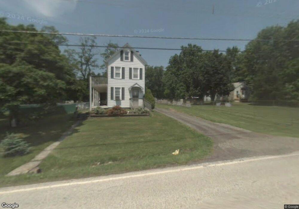
1169 N State St Pottstown, PA 19464
Estimated Value: $219,000 - $359,681
4
Beds
2
Baths
1,809
Sq Ft
$164/Sq Ft
Est. Value
About This Home
This home is located at 1169 N State St, Pottstown, PA 19464 and is currently estimated at $297,170, approximately $164 per square foot. 1169 N State St is a home located in Montgomery County with nearby schools including Lower Pottsgrove Elementary School, Pottsgrove Middle School, and Pottsgrove Senior High School.
Ownership History
Date
Name
Owned For
Owner Type
Purchase Details
Closed on
Nov 11, 2022
Sold by
Harper Jennifer L and Puzzangara Jennifer
Bought by
Harper Jennifer L and Harper Eric J
Current Estimated Value
Home Financials for this Owner
Home Financials are based on the most recent Mortgage that was taken out on this home.
Original Mortgage
$170,150
Outstanding Balance
$164,998
Interest Rate
7.08%
Mortgage Type
New Conventional
Estimated Equity
$132,172
Purchase Details
Closed on
Aug 27, 2004
Sold by
Sell Scott A and Sell Sonya L
Bought by
Puzzangara Jennifer and Bielawski Faith B
Purchase Details
Closed on
Nov 20, 1998
Sold by
Brand Linda and Dedrick Linda
Bought by
Sell Scott A and Sell Sonya L
Create a Home Valuation Report for This Property
The Home Valuation Report is an in-depth analysis detailing your home's value as well as a comparison with similar homes in the area
Home Values in the Area
Average Home Value in this Area
Purchase History
| Date | Buyer | Sale Price | Title Company |
|---|---|---|---|
| Harper Jennifer L | -- | None Listed On Document | |
| Puzzangara Jennifer | $133,900 | Penn Title Inc | |
| Sell Scott A | $97,500 | -- |
Source: Public Records
Mortgage History
| Date | Status | Borrower | Loan Amount |
|---|---|---|---|
| Open | Harper Jennifer L | $170,150 |
Source: Public Records
Tax History Compared to Growth
Tax History
| Year | Tax Paid | Tax Assessment Tax Assessment Total Assessment is a certain percentage of the fair market value that is determined by local assessors to be the total taxable value of land and additions on the property. | Land | Improvement |
|---|---|---|---|---|
| 2025 | $5,191 | $105,870 | -- | -- |
| 2024 | $5,191 | $105,870 | -- | -- |
| 2023 | $5,030 | $105,870 | $0 | $0 |
| 2022 | $4,954 | $105,870 | $0 | $0 |
| 2021 | $4,883 | $105,870 | $0 | $0 |
| 2020 | $4,865 | $105,870 | $0 | $0 |
| 2019 | $4,840 | $105,870 | $0 | $0 |
| 2018 | $830 | $105,870 | $0 | $0 |
| 2017 | $4,856 | $105,870 | $0 | $0 |
| 2016 | $4,814 | $105,870 | $0 | $0 |
| 2015 | $4,705 | $105,870 | $0 | $0 |
| 2014 | $4,705 | $100,320 | $44,890 | $55,430 |
Source: Public Records
Map
Nearby Homes
- 67 Steinmetz Rd
- 817 N State St
- 159 Stone Hill Dr
- 1100 Levengood Rd
- 551 Upland St
- 559 Belmont St
- 666 Manatawny St
- 1405 Old Glasgow St
- 1445 Farmington Ave
- 700 Farmington Ave Unit 40
- 742 N Hanover St
- 1440 Farmington Ave Unit 11
- 646 Willow St
- 1026 Elmwood Dr
- 482 Manatawny St
- 186 Maugers Mill Rd
- 794 Spruce St
- 792 Spruce St
- 792-794 Spruce St
- 104 Maugers Mill Rd