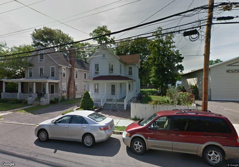
117 Broad St Hightstown, NJ 08520
Estimated Value: $360,000 - $506,000
3
Beds
1
Bath
1,560
Sq Ft
$274/Sq Ft
Est. Value
About This Home
This home is located at 117 Broad St, Hightstown, NJ 08520 and is currently estimated at $427,766, approximately $274 per square foot. 117 Broad St is a home located in Mercer County with nearby schools including Melvin H. Kreps Middle School, Hightstown High School, and SciCore Academy.
Ownership History
Date
Name
Owned For
Owner Type
Purchase Details
Closed on
Jul 20, 2007
Sold by
Pastore Frances and Rast Rita Rast
Bought by
Ayabaca Juan and Ayabaca Maria N
Current Estimated Value
Home Financials for this Owner
Home Financials are based on the most recent Mortgage that was taken out on this home.
Interest Rate
6.73%
Purchase Details
Closed on
Mar 4, 2004
Sold by
Pastore Frances
Bought by
Pastore Frances
Home Financials for this Owner
Home Financials are based on the most recent Mortgage that was taken out on this home.
Interest Rate
5.59%
Create a Home Valuation Report for This Property
The Home Valuation Report is an in-depth analysis detailing your home's value as well as a comparison with similar homes in the area
Home Values in the Area
Average Home Value in this Area
Purchase History
| Date | Buyer | Sale Price | Title Company |
|---|---|---|---|
| Ayabaca Juan | -- | -- | |
| Pastore Frances | -- | -- |
Source: Public Records
Mortgage History
| Date | Status | Borrower | Loan Amount |
|---|---|---|---|
| Closed | Pastore Frances | -- | |
| Previous Owner | Pastore Frances | -- |
Source: Public Records
Tax History Compared to Growth
Tax History
| Year | Tax Paid | Tax Assessment Tax Assessment Total Assessment is a certain percentage of the fair market value that is determined by local assessors to be the total taxable value of land and additions on the property. | Land | Improvement |
|---|---|---|---|---|
| 2025 | $7,256 | $148,000 | $74,500 | $73,500 |
| 2024 | $7,182 | $148,000 | $74,500 | $73,500 |
| 2023 | $7,182 | $148,000 | $74,500 | $73,500 |
| 2022 | $6,934 | $148,000 | $74,500 | $73,500 |
| 2021 | $6,684 | $148,000 | $74,500 | $73,500 |
| 2020 | $6,531 | $148,000 | $74,500 | $73,500 |
| 2019 | $6,349 | $148,000 | $74,500 | $73,500 |
| 2018 | $6,164 | $148,000 | $74,500 | $73,500 |
| 2017 | $6,101 | $148,000 | $74,500 | $73,500 |
| 2016 | $6,047 | $148,000 | $74,500 | $73,500 |
| 2015 | $6,009 | $148,000 | $74,500 | $73,500 |
| 2014 | $6,047 | $148,000 | $74,500 | $73,500 |
Source: Public Records
Map
Nearby Homes
- 344 Monmouth St
- 219 Maxwell Ave
- 23 Barton Dr
- 4 Brakeman Ct
- 104 1st Ave
- 164 Mill Run E Unit 141
- 302 S Main St
- 336 Monmouth St
- 5 Mill Run W
- 43 Norton Ave
- 1 Huber Ct
- 23 Powell Ct
- 203 Hutchinson St
- 309 Lincoln Ave
- 126 Mill Run E
- 126 Mill Run E Unit 84
- 124 Mill Run E Unit 85
- 201 Morrison Ave
- 4 Sandstone Rd
- 145 Lincoln Ave
- 113 Broad St
- 131 Broad St
- 113 Broadway Rd
- 105 Franklin St
- 120 Broad St
- 110 Broad St
- 100 Broad St
- 100 Broad St Unit 2
- 163 N Main St
- 161 N Main St Unit A
- 161 N Main St
- 109 Franklin St
- 119 Franklin St
- 124 Broad St
- 111 Franklin St
- 153 N Main St Unit 57
- 147-151 N Main St
- 147-151 N Main St
- 147 N Main St
- 102 Broad St