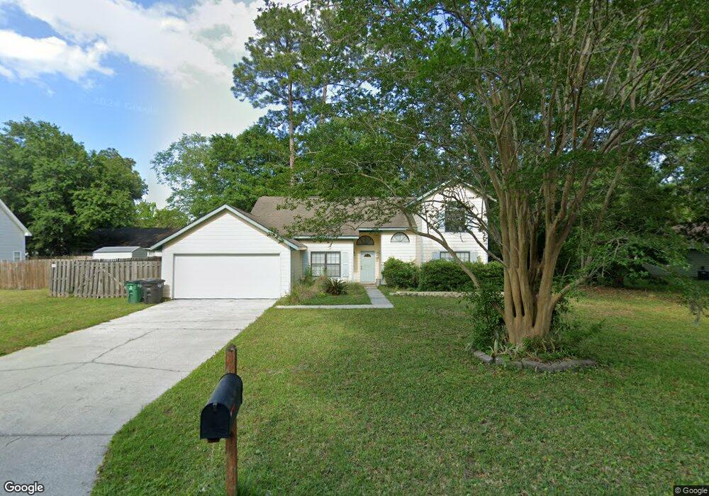
117 Dunbar Dr Saint Marys, GA 31558
Estimated Value: $299,524 - $319,000
3
Beds
2
Baths
1,749
Sq Ft
$176/Sq Ft
Est. Value
About This Home
This home is located at 117 Dunbar Dr, Saint Marys, GA 31558 and is currently estimated at $307,881, approximately $176 per square foot. 117 Dunbar Dr is a home located in Camden County with nearby schools including Mary Lee Clark Elementary School, Saint Marys Middle School, and Camden County High School.
Ownership History
Date
Name
Owned For
Owner Type
Purchase Details
Closed on
May 17, 2022
Sold by
Meador Robert
Bought by
Anderson Mary
Current Estimated Value
Home Financials for this Owner
Home Financials are based on the most recent Mortgage that was taken out on this home.
Original Mortgage
$137,920
Outstanding Balance
$130,378
Interest Rate
4.72%
Mortgage Type
New Conventional
Estimated Equity
$177,503
Purchase Details
Closed on
Apr 27, 2016
Sold by
Cox Amy R
Bought by
Meador Robert and Meador Maryann
Home Financials for this Owner
Home Financials are based on the most recent Mortgage that was taken out on this home.
Original Mortgage
$108,382
Interest Rate
3.71%
Mortgage Type
New Conventional
Purchase Details
Closed on
Jul 23, 2008
Sold by
Trochak Edward J
Bought by
Cox Amy R
Home Financials for this Owner
Home Financials are based on the most recent Mortgage that was taken out on this home.
Original Mortgage
$83,087
Interest Rate
6.43%
Mortgage Type
FHA
Create a Home Valuation Report for This Property
The Home Valuation Report is an in-depth analysis detailing your home's value as well as a comparison with similar homes in the area
Home Values in the Area
Average Home Value in this Area
Purchase History
| Date | Buyer | Sale Price | Title Company |
|---|---|---|---|
| Anderson Mary | $175,000 | -- | |
| Meador Robert | $144,540 | -- | |
| Cox Amy R | $85,000 | -- |
Source: Public Records
Mortgage History
| Date | Status | Borrower | Loan Amount |
|---|---|---|---|
| Open | Anderson Mary | $137,920 | |
| Previous Owner | Meador Robert | $108,382 | |
| Previous Owner | Cox Amy R | $83,087 |
Source: Public Records
Tax History Compared to Growth
Tax History
| Year | Tax Paid | Tax Assessment Tax Assessment Total Assessment is a certain percentage of the fair market value that is determined by local assessors to be the total taxable value of land and additions on the property. | Land | Improvement |
|---|---|---|---|---|
| 2024 | $3,669 | $106,652 | $14,000 | $92,652 |
| 2023 | $3,469 | $97,767 | $14,000 | $83,767 |
| 2022 | $2,271 | $77,624 | $14,000 | $63,624 |
| 2021 | $2,039 | $65,952 | $14,000 | $51,952 |
| 2020 | $2,041 | $64,211 | $14,000 | $50,211 |
| 2019 | $2,041 | $64,211 | $14,000 | $50,211 |
| 2018 | $417 | $64,211 | $14,000 | $50,211 |
| 2017 | $1,670 | $55,587 | $10,000 | $45,587 |
| 2016 | $1,572 | $52,515 | $10,000 | $42,515 |
| 2015 | $1,405 | $52,515 | $10,000 | $42,515 |
| 2014 | $1,343 | $50,515 | $8,000 | $42,515 |
Source: Public Records
Map
Nearby Homes
- 130 Dunbar Dr
- 173 Natures Dr
- 407 Hunt Club Rd
- 111 Snapper Ct
- 987 Charlie Smith Sr Hwy
- 211 Victorias Cir
- 133 4th St
- 112 Blairs Ct
- 500 Sand Bar Dr
- 101 Elliott Way
- 401 Victorias Cir
- 606 Victorias Cir
- 321 Sandhill Rd
- 101 Bachlott Rd
- 207 Wild Grape Dr
- 303 Maggie Way
- 142 Hamilton Dr
- 110 Juliana Place
- 3852 Georgia 40
- 147 Teakwood Dr
- 105 Royal Ct
- 115 Dunbar Dr
- 119 Dunbar Dr
- 107 Royal Ct
- 118 Dunbar Dr
- 118 Dunbar Dr Unit 1
- 0 Baronet Ct
- 120 Dunbar Dr
- 103 Royal Ct
- 116 Dunbar Dr
- 113 Dunbar Dr
- 0 Royal Ct Unit 8475677
- 0 Royal Ct
- 121 Dunbar Dr
- 0 Dunbar Dr Unit 7445254
- 0 Dunbar Dr Unit 7124326
- 0 Dunbar Dr Unit 8756018
- 0 Dunbar Dr Unit 8604519
- 0 Dunbar Dr Unit 8387036
- 0 Dunbar Dr Unit 8365123