Estimated Value: $215,000 - $290,234
3
Beds
3
Baths
2,164
Sq Ft
$120/Sq Ft
Est. Value
About This Home
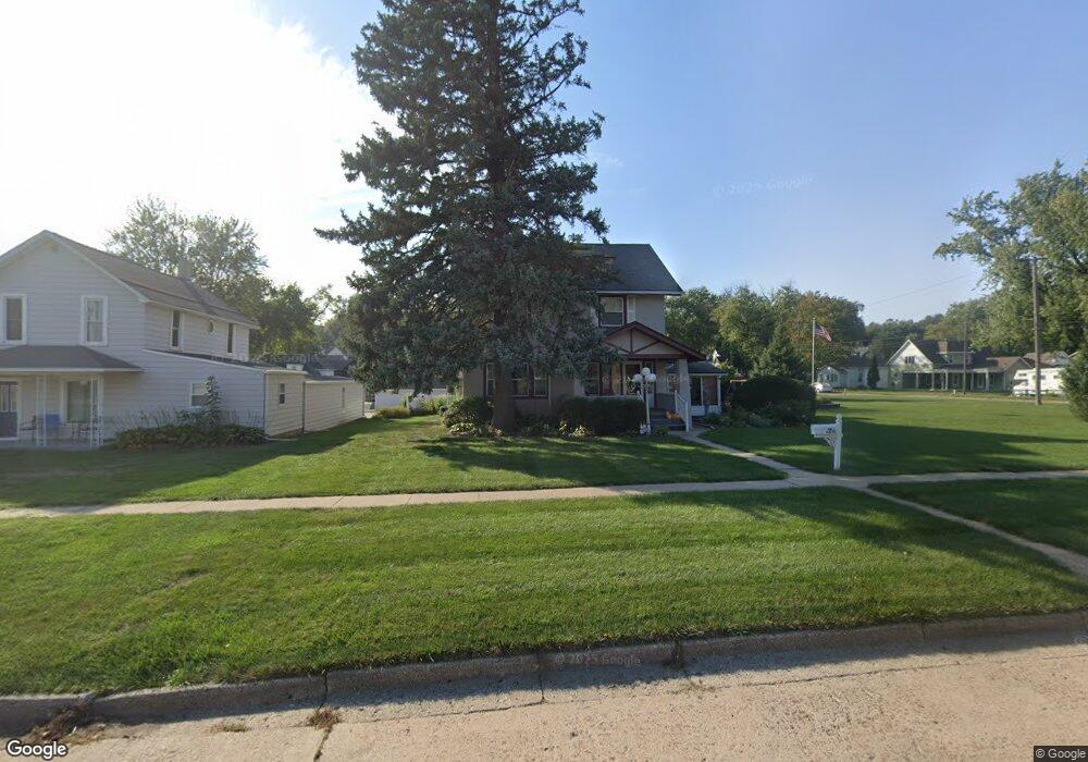
This home is located at 117 N 1st Ave, Logan, IA 51546 and is currently estimated at $260,309, approximately $120 per square foot. 117 N 1st Ave is a home located in Harrison County with nearby schools including Logan-Magnolia Elementary School and Logan-Magnolia Junior/Senior High School.
Ownership History
Date
Name
Owned For
Owner Type
Purchase Details
Closed on
Oct 3, 2024
Sold by
Greenwood Michael P and Greenwood Cheryl L
Bought by
Greenwood Michael P and Greenwood Cheryl L
Current Estimated Value
Purchase Details
Closed on
Mar 9, 2015
Sold by
Greenwood Ronald L and Greenwood Sharon A
Bought by
Ronald L And Sharon A Greenwood Joint Re
Create a Home Valuation Report for This Property
The Home Valuation Report is an in-depth analysis detailing your home's value as well as a comparison with similar homes in the area
Home Values in the Area
Average Home Value in this Area
Purchase History
| Date | Buyer | Sale Price | Title Company |
|---|---|---|---|
| Greenwood Michael P | -- | None Listed On Document | |
| Greenwood Michael P | -- | None Listed On Document | |
| Ronald L And Sharon A Greenwood Joint Re | -- | None Available |
Source: Public Records
Tax History Compared to Growth
Tax History
| Year | Tax Paid | Tax Assessment Tax Assessment Total Assessment is a certain percentage of the fair market value that is determined by local assessors to be the total taxable value of land and additions on the property. | Land | Improvement |
|---|---|---|---|---|
| 2025 | $4,892 | $310,170 | $15,750 | $294,420 |
| 2024 | $4,892 | $278,370 | $15,750 | $262,620 |
| 2023 | $4,722 | $278,370 | $15,750 | $262,620 |
| 2022 | $3,986 | $204,451 | $15,750 | $188,701 |
| 2021 | $3,986 | $204,451 | $15,750 | $188,701 |
| 2020 | $3,604 | $190,217 | $15,750 | $174,467 |
| 2019 | $2,874 | $190,217 | $15,750 | $174,467 |
| 2018 | $2,644 | $143,502 | $0 | $0 |
| 2017 | $2,644 | $143,502 | $0 | $0 |
| 2016 | $2,772 | $143,502 | $0 | $0 |
| 2015 | $2,772 | $129,281 | $0 | $0 |
| 2014 | $2,396 | $129,281 | $0 | $0 |
Source: Public Records
Map
Nearby Homes
- 114 E 10th St
- 721 Glen Rd
- 1010 Skyline Dr
- 415 Wessar Dr
- Lot 18 Mulligan Trail
- 2607 220th St
- LOT 27 Mulligan Trail
- 2484 280th St
- LOT 26 Lmvcc Estates
- 2144 Norton Ave
- 2464 Mulligan Trail
- LOT 20 Lmvcc Estates
- LOT 17 Lmvcc Estates
- Lot 17 Lmvcc Estates Trail
- LOT 15 Mulligan Trail
- 2853 Preston Place
- 2740 Whitetail Dr
- LOT D Fieldcrest Dr
- LOT E & K Fieldcrest Dr
- LOT C Fieldcrest Dr