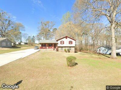
117 N Lake Dr Lagrange, GA 30240
Estimated Value: $211,550 - $248,000
3
Beds
2
Baths
1,353
Sq Ft
$165/Sq Ft
Est. Value
About This Home
This home is located at 117 N Lake Dr, Lagrange, GA 30240 and is currently estimated at $222,888, approximately $164 per square foot. 117 N Lake Dr is a home located in Troup County with nearby schools including Ethel W. Kight Elementary School, Hollis Hand Elementary School, and Franklin Forest Elementary School.
Ownership History
Date
Name
Owned For
Owner Type
Purchase Details
Closed on
Jul 12, 1988
Sold by
Gordon Simmons
Bought by
Hood Lloyd L
Current Estimated Value
Purchase Details
Closed on
Jul 1, 1985
Sold by
Richard Richard W and Richard Rebecca
Bought by
Gordon Simmons
Purchase Details
Closed on
Jul 17, 1978
Sold by
Dan Durand H
Bought by
Richard Richard W and Richard Rebecca
Purchase Details
Closed on
Feb 17, 1978
Sold by
Dan-Ric Inc
Bought by
Dan Durand H
Purchase Details
Closed on
Feb 14, 1978
Sold by
Dan Durand
Bought by
Dan-Ric Inc
Purchase Details
Closed on
Jan 3, 1977
Bought by
Dan Durand
Create a Home Valuation Report for This Property
The Home Valuation Report is an in-depth analysis detailing your home's value as well as a comparison with similar homes in the area
Home Values in the Area
Average Home Value in this Area
Purchase History
| Date | Buyer | Sale Price | Title Company |
|---|---|---|---|
| Hood Lloyd L | $21,200 | -- | |
| Gordon Simmons | -- | -- | |
| Richard Richard W | $42,000 | -- | |
| Dan Durand H | -- | -- | |
| Dan-Ric Inc | -- | -- | |
| Dan Durand | -- | -- |
Source: Public Records
Tax History Compared to Growth
Tax History
| Year | Tax Paid | Tax Assessment Tax Assessment Total Assessment is a certain percentage of the fair market value that is determined by local assessors to be the total taxable value of land and additions on the property. | Land | Improvement |
|---|---|---|---|---|
| 2024 | $703 | $54,828 | $10,000 | $44,828 |
| 2023 | $281 | $55,976 | $10,000 | $45,976 |
| 2022 | $707 | $53,936 | $10,000 | $43,936 |
| 2021 | $497 | $45,200 | $8,000 | $37,200 |
| 2020 | $1,063 | $45,200 | $8,000 | $37,200 |
| 2019 | $727 | $34,080 | $4,000 | $30,080 |
| 2018 | $645 | $31,360 | $4,000 | $27,360 |
| 2017 | $645 | $31,360 | $4,000 | $27,360 |
| 2016 | $619 | $30,462 | $4,000 | $26,462 |
| 2015 | $861 | $30,462 | $4,000 | $26,462 |
| 2014 | $820 | $29,069 | $4,000 | $25,069 |
| 2013 | -- | $30,433 | $4,000 | $26,433 |
Source: Public Records
Map
Nearby Homes
- 709 Vernon Ferry Rd
- 100 Bonny Oaks Ct
- 0 Vernon Ferry Rd Unit 10224914
- 207 Lakeshore Way
- 4004 White Oak Ln
- 208 Linda Ln
- 110 W Pyne Dr
- 226 Linda Ln
- 2 AC Angela Dr
- 5006 Riverside Ln
- 135 Planters Ridge Dr
- 116 Highland Pointe Dr
- 189 Tatum Heights Dr
- 124 Foxdale Dr
- 101 Planters Ridge Dr Unit LOT 13
- 110 Highland Trail
- 190 Hill Rd
- 242 Newton Rd
- 328 Whitaker Rd
- 49 Post Oak Dr