
Seller's Agent in 2025
Kristin Weekley
Leading Edge Real Estate
(781) 454-8493
1 in this area
252 Total Sales

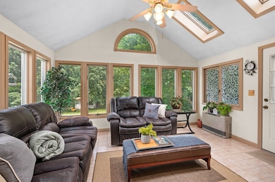


Welcome to 117 Rolling Ridge Lane! The perfect blend of convenience and serenity, this home features a recently renovated kitchen, a dining room and living room with brand new hardwood flooring, three generously sized bedrooms and a full bathroom on the main level. Central air keeps you cool! Topping it off is the stunning heated sunroom sanctuary with vaulted ceilings and direct access to a multilevel composite deck. The lower level has wonderfully flexible space for a family room, play room, home office, home gym, man cave, or use for the in-laws! You can have them all, plus extra storage, laundry, and a half bath. Outside, you can enjoy the fresh air and serenity of this quiet location in the oversized yard, or have your morning coffee on the massive deck. Or pull out of your attached garage and be at The Loop in under ten minutes, so shopping, fun, and commuting are a breeze. Don't miss this one!
| Date | Type | Sale Price | Title Company |
|---|---|---|---|
| Deed | $680,000 | -- | |
| Deed | $680,000 | -- | |
| Deed | $256,000 | -- | |
| Deed | $256,000 | -- | |
| Deed | $167,000 | -- | |
| Deed | $167,000 | -- |
| Date | Status | Loan Amount | Loan Type |
|---|---|---|---|
| Previous Owner | $256,000 | No Value Available | |
| Previous Owner | $186,000 | No Value Available | |
| Previous Owner | $183,000 | Purchase Money Mortgage |
| Date | Event | Price | List to Sale | Price per Sq Ft |
|---|---|---|---|---|
| 08/18/2025 08/18/25 | Sold | $680,000 | +13.4% | $347 / Sq Ft |
| 07/08/2025 07/08/25 | Pending | -- | -- | -- |
| 07/07/2025 07/07/25 | For Sale | $599,900 | -- | $306 / Sq Ft |
| Year | Tax Paid | Tax Assessment Tax Assessment Total Assessment is a certain percentage of the fair market value that is determined by local assessors to be the total taxable value of land and additions on the property. | Land | Improvement |
|---|---|---|---|---|
| 2025 | $6,048 | $571,600 | $246,800 | $324,800 |
| 2024 | $6,050 | $557,100 | $224,400 | $332,700 |
| 2023 | $5,751 | $491,500 | $200,400 | $291,100 |
| 2022 | $5,414 | $414,900 | $160,300 | $254,600 |
| 2021 | $5,138 | $389,500 | $152,300 | $237,200 |
| 2020 | $5,095 | $379,100 | $152,300 | $226,800 |
| 2019 | $4,971 | $350,300 | $144,300 | $206,000 |
| 2018 | $4,796 | $336,100 | $144,300 | $191,800 |
| 2017 | $4,612 | $314,800 | $144,300 | $170,500 |
| 2016 | $4,556 | $307,600 | $144,300 | $163,300 |
| 2015 | $4,400 | $301,400 | $144,300 | $157,100 |
Seller's Agent in 2025
Kristin Weekley
Leading Edge Real Estate
(781) 454-8493
1 in this area
252 Total Sales
Buyer's Agent in 2025
Felicia Giuliano
Classified Realty Group
(617) 281-9221
1 in this area
153 Total Sales
Source: MLS Property Information Network (MLS PIN)
MLS Number: 73400062
APN: METH-000808-000077-000067F
Disclaimer: Certain information contained herein is derived from information provided by parties other than Homes.com. All information provided is deemed reliable, but is not guaranteed to be accurate and should be independently verified.
![]() The property listing data and information, or the Images, set forth herein were provided to MLS Property Information Network, Inc. from third party sources, including sellers, lessors and public records, and were compiled by MLS Property Information Network, Inc. The property listing data and information, and the Images, are for the personal, non-commercial use of consumers having a good faith interest in purchasing or leasing listed properties of the type displayed to them and may not be used for any purpose other than to identify prospective properties which such consumers may have a good faith interest in purchasing or leasing. MLS Property Information Network, Inc. and its subscribers disclaim any and all representations and warranties as to the accuracy of the property listing data and information, or as to the accuracy of any of the Images, set forth herein.
The property listing data and information, or the Images, set forth herein were provided to MLS Property Information Network, Inc. from third party sources, including sellers, lessors and public records, and were compiled by MLS Property Information Network, Inc. The property listing data and information, and the Images, are for the personal, non-commercial use of consumers having a good faith interest in purchasing or leasing listed properties of the type displayed to them and may not be used for any purpose other than to identify prospective properties which such consumers may have a good faith interest in purchasing or leasing. MLS Property Information Network, Inc. and its subscribers disclaim any and all representations and warranties as to the accuracy of the property listing data and information, or as to the accuracy of any of the Images, set forth herein.