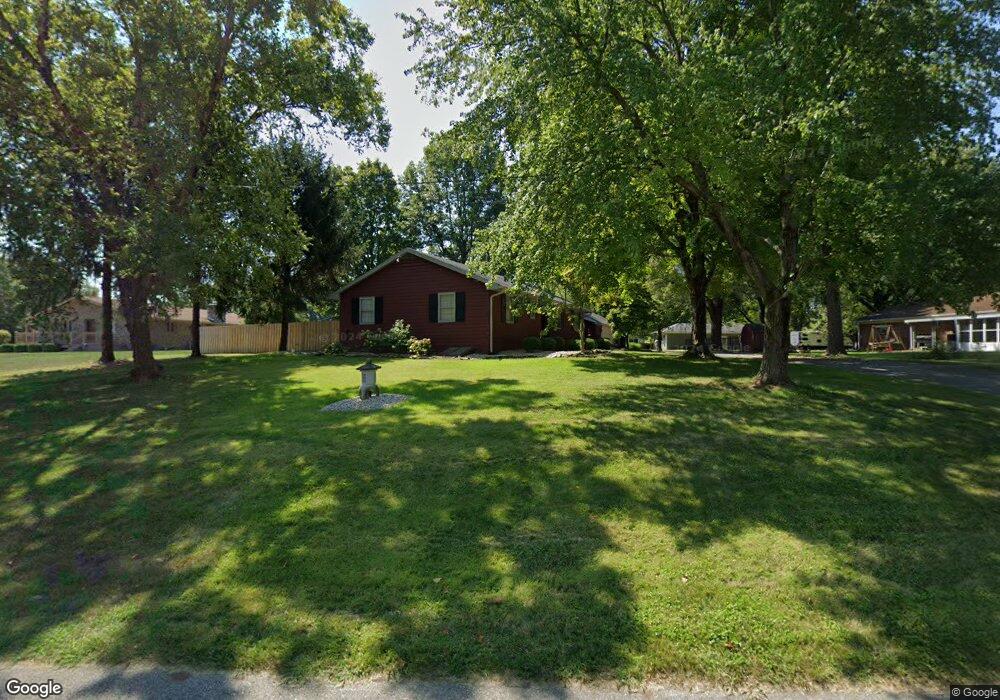
117 Rolling Ridge Rd Shelbyville, IN 46176
Estimated Value: $228,000 - $251,522
2
Beds
2
Baths
1,605
Sq Ft
$149/Sq Ft
Est. Value
About This Home
This home is located at 117 Rolling Ridge Rd, Shelbyville, IN 46176 and is currently estimated at $238,881, approximately $148 per square foot. 117 Rolling Ridge Rd is a home located in Shelby County with nearby schools including Coulston Elementary School, Shelbyville Middle School, and Shelbyville Senior High School.
Ownership History
Date
Name
Owned For
Owner Type
Purchase Details
Closed on
Feb 14, 2023
Sold by
Ogden Patricia A
Bought by
Lacy Larry R and Taylor Jill R
Current Estimated Value
Home Financials for this Owner
Home Financials are based on the most recent Mortgage that was taken out on this home.
Original Mortgage
$210,000
Outstanding Balance
$203,587
Interest Rate
6.48%
Mortgage Type
New Conventional
Estimated Equity
$35,294
Create a Home Valuation Report for This Property
The Home Valuation Report is an in-depth analysis detailing your home's value as well as a comparison with similar homes in the area
Home Values in the Area
Average Home Value in this Area
Purchase History
| Date | Buyer | Sale Price | Title Company |
|---|---|---|---|
| Lacy Larry R | -- | None Listed On Document |
Source: Public Records
Mortgage History
| Date | Status | Borrower | Loan Amount |
|---|---|---|---|
| Open | Lacy Larry R | $210,000 |
Source: Public Records
Tax History Compared to Growth
Tax History
| Year | Tax Paid | Tax Assessment Tax Assessment Total Assessment is a certain percentage of the fair market value that is determined by local assessors to be the total taxable value of land and additions on the property. | Land | Improvement |
|---|---|---|---|---|
| 2024 | $1,804 | $180,400 | $28,200 | $152,200 |
| 2023 | $1,273 | $152,000 | $28,200 | $123,800 |
| 2022 | $1,248 | $153,600 | $28,200 | $125,400 |
| 2021 | $1,223 | $142,400 | $28,200 | $114,200 |
| 2020 | $1,199 | $137,700 | $28,200 | $109,500 |
| 2019 | $1,176 | $133,900 | $28,200 | $105,700 |
| 2018 | $1,153 | $124,300 | $28,200 | $96,100 |
| 2017 | $1,393 | $139,300 | $28,200 | $111,100 |
| 2016 | $1,108 | $136,000 | $28,200 | $107,800 |
| 2014 | $1,065 | $138,300 | $28,200 | $110,100 |
| 2013 | $1,065 | $138,300 | $28,200 | $110,100 |
Source: Public Records
Map
Nearby Homes
- 13 W Rampart St
- 22 Rampart Rd W
- 1690 Cardinal Ln
- Walnut Plan at Isabelle Farms
- Norway Plan at Isabelle Farms
- Aspen II Plan at Isabelle Farms
- Juniper Plan at Isabelle Farms
- Empress Plan at Isabelle Farms
- Palmetto Plan at Isabelle Farms
- Ashton Plan at Isabelle Farms
- Cooper Plan at Isabelle Farms
- Chestnut Plan at Isabelle Farms
- Bradford Plan at Isabelle Farms
- 20 Isabelle Ln
- Ironwood Plan at Isabelle Farms
- Spruce Plan at Isabelle Farms
- 10 Isabelle Ln
- 2326 Saddle Dr
- 2327 Saddle Dr
- 2331 Saddle Dr
- 1584 Crest Dr
- 115 Rolling Ridge Rd
- 1582 Crest Dr
- 116 Rolling Ridge Rd
- 114 Rolling Ridge Rd
- 114 Rolling Ridge Rd Unit 42
- 112 Rolling Ridge Rd
- 113 Rolling Ridge Rd
- 1580 Crest Dr
- 1581 Edgehill Rd
- 119 Rolling Ridge Rd
- 118 Rolling Ridge Rd
- 1581 Crest Dr
- 1693 Edgehill Rd
- 1579 Edgehill Rd
- 113 Rampart St
- 115 Rampart St
- 111 Rampart St
- 1578 Crest Dr
- 1695 Edgehill Rd