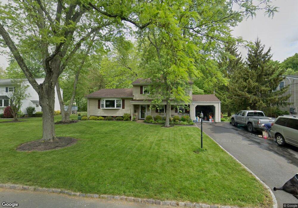
117 Runnymede Pkwy New Providence, NJ 07974
Estimated Value: $727,000 - $998,000
--
Bed
--
Bath
2,198
Sq Ft
$397/Sq Ft
Est. Value
About This Home
This home is located at 117 Runnymede Pkwy, New Providence, NJ 07974 and is currently estimated at $871,787, approximately $396 per square foot. 117 Runnymede Pkwy is a home located in Union County with nearby schools including New Providence High School and The Academy of Our Lady of Peace.
Ownership History
Date
Name
Owned For
Owner Type
Purchase Details
Closed on
Aug 11, 1998
Sold by
Schweiger Hal
Bought by
Dragos Martin P and Mills Susan C
Current Estimated Value
Home Financials for this Owner
Home Financials are based on the most recent Mortgage that was taken out on this home.
Original Mortgage
$227,150
Interest Rate
6.6%
Create a Home Valuation Report for This Property
The Home Valuation Report is an in-depth analysis detailing your home's value as well as a comparison with similar homes in the area
Home Values in the Area
Average Home Value in this Area
Purchase History
| Date | Buyer | Sale Price | Title Company |
|---|---|---|---|
| Dragos Martin P | $330,000 | Stewart Title Guaranty Compa |
Source: Public Records
Mortgage History
| Date | Status | Borrower | Loan Amount |
|---|---|---|---|
| Closed | Dragos Martin P | $227,150 |
Source: Public Records
Tax History Compared to Growth
Tax History
| Year | Tax Paid | Tax Assessment Tax Assessment Total Assessment is a certain percentage of the fair market value that is determined by local assessors to be the total taxable value of land and additions on the property. | Land | Improvement |
|---|---|---|---|---|
| 2025 | $16,142 | $312,700 | $143,500 | $169,200 |
| 2024 | $15,657 | $312,700 | $143,500 | $169,200 |
| 2023 | $15,657 | $312,700 | $143,500 | $169,200 |
| 2022 | $15,441 | $312,700 | $143,500 | $169,200 |
| 2021 | $15,329 | $312,700 | $143,500 | $169,200 |
| 2020 | $15,322 | $312,700 | $143,500 | $169,200 |
| 2019 | $15,228 | $312,700 | $143,500 | $169,200 |
| 2018 | $15,150 | $312,700 | $143,500 | $169,200 |
| 2017 | $14,903 | $312,700 | $143,500 | $169,200 |
| 2016 | $14,694 | $312,700 | $143,500 | $169,200 |
| 2015 | $14,491 | $312,700 | $143,500 | $169,200 |
| 2014 | $14,272 | $312,700 | $143,500 | $169,200 |
Source: Public Records
Map
Nearby Homes
- 14 Holmes Oval
- 36 Terrace Rd
- 32 Charnwood Rd
- 16 Terrace Rd
- 567 River Rd
- 29 Walton Ave
- 1200 Springfield Ave Unit 1B
- 131 van Houton Ave
- 19 Slope Dr
- 20 High St
- 32 Marion Ave
- 100 Commonwealth Ave
- 5 Kincaid Ln
- 16 Riverbend Ct
- 197 Elkwood Ave
- 45 Runnymede Rd
- 282 South St
- 11 Earl Place
- 34 Grant Ave
- 54 Badgley Dr
- 111 Runnymede Pkwy
- 127 Runnymede Pkwy
- 118 Runnymede Pkwy
- 105 Runnymede Pkwy
- 71 Ridgeview Ave
- 128 Runnymede Pkwy
- 75 Ridgeview Ave
- 112 Runnymede Pkwy
- 79 Ridgeview Ave
- 63 Ridgeview Ave
- 55 Holmes Oval
- 83 Ridgeview Ave
- 97 Runnymede Pkwy
- 53 Holmes Oval
- 102 Runnymede Pkwy
- 59 Holmes Oval N
- 63 Holmes Oval
- 51 Holmes Oval
- 67 Holmes Oval N
- 59 Holmes Oval