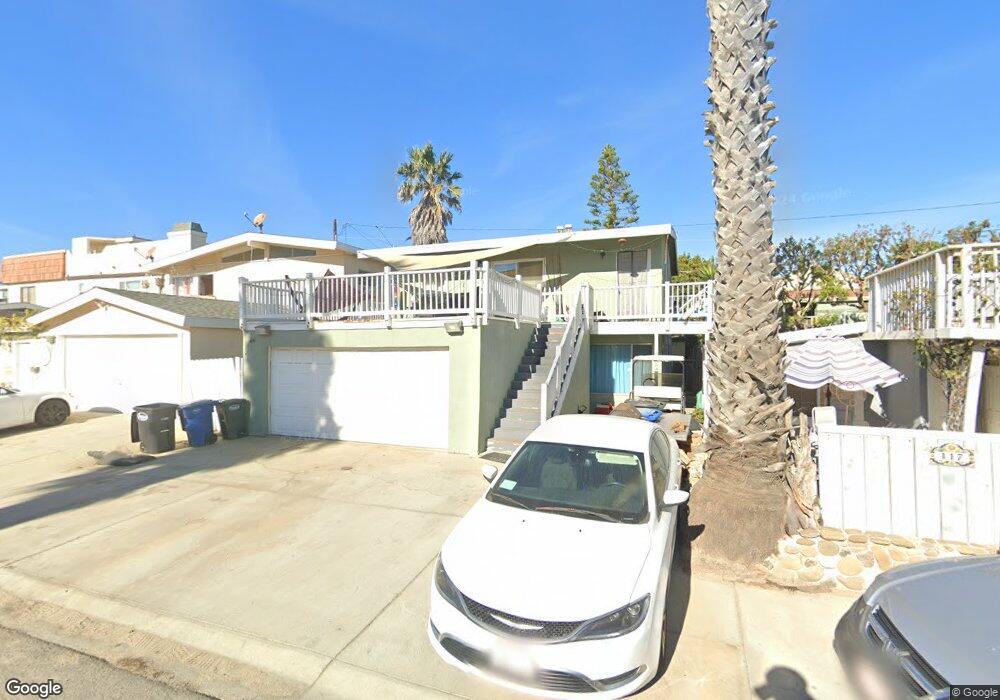
117 Santa Paula Ave Oxnard, CA 93035
Silver Strand NeighborhoodEstimated Value: $957,098 - $1,131,000
2
Beds
1
Bath
870
Sq Ft
$1,175/Sq Ft
Est. Value
About This Home
This home is located at 117 Santa Paula Ave, Oxnard, CA 93035 and is currently estimated at $1,022,275, approximately $1,175 per square foot. 117 Santa Paula Ave is a home located in Ventura County with nearby schools including Hollywood Beach Elementary School, Oxnard High School, and St. Anthony's Elementary School.
Ownership History
Date
Name
Owned For
Owner Type
Purchase Details
Closed on
Sep 18, 1998
Sold by
Ross Gary M and Ross Diana M
Bought by
Ross Gary M and Ross Diana M
Current Estimated Value
Purchase Details
Closed on
Jun 11, 1998
Sold by
Ross Gary M and Ross Diana M
Bought by
Ross Gary M and Ross Diana M
Home Financials for this Owner
Home Financials are based on the most recent Mortgage that was taken out on this home.
Original Mortgage
$143,000
Outstanding Balance
$28,558
Interest Rate
7.03%
Estimated Equity
$993,717
Purchase Details
Closed on
Nov 16, 1995
Sold by
Ross Gary M and Ross Diana M
Bought by
Ross Gary M and Ross Diana M
Purchase Details
Closed on
Nov 1, 1994
Sold by
Barker Jerry E and Barker Mary G
Bought by
Ross Gary M and Ross Diana M
Home Financials for this Owner
Home Financials are based on the most recent Mortgage that was taken out on this home.
Original Mortgage
$146,600
Interest Rate
9.08%
Create a Home Valuation Report for This Property
The Home Valuation Report is an in-depth analysis detailing your home's value as well as a comparison with similar homes in the area
Home Values in the Area
Average Home Value in this Area
Purchase History
| Date | Buyer | Sale Price | Title Company |
|---|---|---|---|
| Ross Gary M | -- | -- | |
| Ross Gary M | -- | Lawyers Title Company | |
| Ross Gary M | -- | -- | |
| Ross Gary M | $196,000 | Lincoln Title Co |
Source: Public Records
Mortgage History
| Date | Status | Borrower | Loan Amount |
|---|---|---|---|
| Open | Ross Gary M | $143,000 | |
| Closed | Ross Gary M | $146,600 |
Source: Public Records
Tax History Compared to Growth
Tax History
| Year | Tax Paid | Tax Assessment Tax Assessment Total Assessment is a certain percentage of the fair market value that is determined by local assessors to be the total taxable value of land and additions on the property. | Land | Improvement |
|---|---|---|---|---|
| 2025 | $3,913 | $332,408 | $256,007 | $76,401 |
| 2024 | $3,913 | $325,891 | $250,988 | $74,903 |
| 2023 | $3,718 | $319,501 | $246,066 | $73,435 |
| 2022 | $3,614 | $313,237 | $241,241 | $71,996 |
| 2021 | $3,613 | $307,096 | $236,511 | $70,585 |
| 2020 | $3,570 | $303,949 | $234,087 | $69,862 |
| 2019 | $3,520 | $297,991 | $229,498 | $68,493 |
| 2018 | $3,402 | $292,149 | $224,999 | $67,150 |
| 2017 | $3,277 | $286,422 | $220,588 | $65,834 |
| 2016 | $3,178 | $280,807 | $216,263 | $64,544 |
| 2015 | $3,100 | $276,590 | $213,015 | $63,575 |
| 2014 | $3,068 | $271,175 | $208,844 | $62,331 |
Source: Public Records
Map
Nearby Homes
- 133 Santa Paula Ave
- 129 Oxnard Ave
- 125 Ventura Ave
- 132 Ojai Ave
- 120 Hueneme Ave
- 2133 Ocean Dr
- 2301 Roosevelt Blvd
- 325 Ocean Dr
- 280 Rossmore Dr Unit 280
- 121 Los Angeles Ave
- 145 Los Angeles Ave
- 141 Los Angeles Ave
- 360 Melrose Dr
- 256 Melrose Dr
- 112 Santa Monica Ave
- 2516 Roosevelt Blvd
- 316 Santa Monica Dr
- 105 Ocean Dr
- 2525 Roosevelt Blvd
- 268 Sunset Dr
- 121 Santa Paula Ave
- 113 Santa Paula Ave
- 116 Fillmore Ave
- 112 Fillmore Ave
- 120 Fillmore Ave
- 129 Santa Paula Ave
- 116 Santa Paula Ave
- 112 Santa Paula Ave
- 120 Santa Paula Ave
- 1308 Ocean Dr
- 1300 Ocean Dr
- 124 Santa Paula Ave
- 108 Santa Paula Ave
- 1316 Ocean Dr
- 126 Santa Paula Ave
- 1324 Ocean Dr
- 1224 Ocean Dr
- 132 Fillmore Ave
- 132 Santa Paula Ave
- 128 Santa Paula Ave