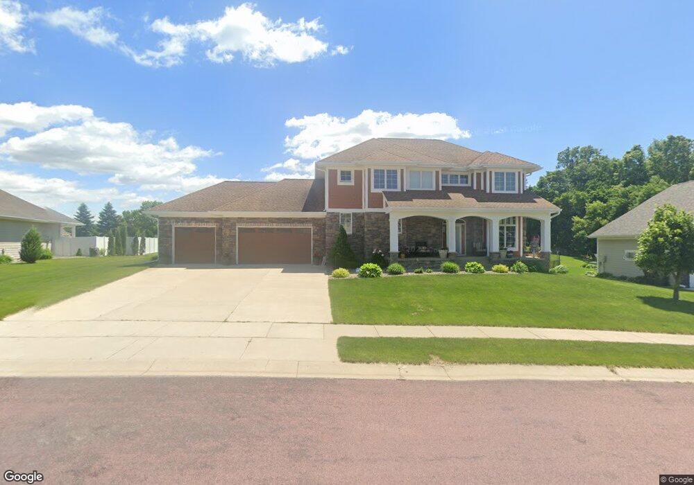
117 Southbrook Way Mankato, MN 56001
Buscher Park NeighborhoodEstimated Value: $640,090 - $851,000
4
Beds
4
Baths
4,032
Sq Ft
$183/Sq Ft
Est. Value
About This Home
This home is located at 117 Southbrook Way, Mankato, MN 56001 and is currently estimated at $737,273, approximately $182 per square foot. 117 Southbrook Way is a home located in Blue Earth County with nearby schools including Rosa Parks Elementary School, Prairie Winds Middle School, and Mankato East Senior High School.
Ownership History
Date
Name
Owned For
Owner Type
Purchase Details
Closed on
Aug 22, 2014
Sold by
Pacheco Bloch Juan M and Palu Amy D
Bought by
Hokeness Jeffrey A and Hokeness Kelley A
Current Estimated Value
Purchase Details
Closed on
Apr 29, 2009
Sold by
Vanden Top Keith and Van Den Top Michelle
Bought by
Pacheco Bloch Juan M and Palu Amy D
Purchase Details
Closed on
Feb 21, 2007
Sold by
Smith Ronald C and Smith Susan M
Bought by
Vandentop Keith and Vandentop Michelle
Create a Home Valuation Report for This Property
The Home Valuation Report is an in-depth analysis detailing your home's value as well as a comparison with similar homes in the area
Home Values in the Area
Average Home Value in this Area
Purchase History
| Date | Buyer | Sale Price | Title Company |
|---|---|---|---|
| Hokeness Jeffrey A | $475,000 | North American Title | |
| Pacheco Bloch Juan M | $445,000 | -- | |
| Vandentop Keith | $49,500 | -- |
Source: Public Records
Tax History Compared to Growth
Tax History
| Year | Tax Paid | Tax Assessment Tax Assessment Total Assessment is a certain percentage of the fair market value that is determined by local assessors to be the total taxable value of land and additions on the property. | Land | Improvement |
|---|---|---|---|---|
| 2025 | $7,398 | $620,500 | $109,600 | $510,900 |
| 2024 | $7,398 | $625,500 | $109,300 | $516,200 |
| 2023 | $7,174 | $631,200 | $109,300 | $521,900 |
| 2022 | $7,100 | $593,100 | $109,300 | $483,800 |
| 2021 | $6,994 | $549,200 | $109,300 | $439,900 |
| 2020 | $6,950 | $536,600 | $109,300 | $427,300 |
| 2019 | $6,536 | $536,600 | $109,300 | $427,300 |
| 2018 | $6,214 | $508,700 | $109,300 | $399,400 |
| 2017 | $5,662 | $488,200 | $109,300 | $378,900 |
| 2016 | $5,638 | $465,400 | $109,300 | $356,100 |
| 2015 | $51 | $465,400 | $109,300 | $356,100 |
| 2014 | $8,406 | $424,200 | $109,300 | $314,900 |
Source: Public Records
Map
Nearby Homes
- TBD S Brook Way
- 0 Tbd South Brook Way
- 213 Rosewood Dr
- 216 S Brook Cir
- 112 Rosewood Dr Unit 108 Rosewood Drive
- 113 Sunburst Cir
- 20206 Monks Ave
- 208 Chancery Ln
- 108 Ella Ct
- 101 Wickfield Dr
- 109 Emily Ln
- 121 Viking Ct
- 309 Viking Dr
- TBD Woodridge
- 124 Joshua Ct
- 128 Timberwolf Ct
- 1008 Applewood Ct
- 121 Savannah Ct
- 117 Savannah Ct
- 27 Capri Dr
- 117 117 South Brook Way
- 117 117 South Brook-Way-
- 117 S Brook Way
- 113 Southbrook Way
- 113 113 South Brook Way
- 121 S Brook Way
- 121 Southbrook Way
- 145 Hidden Oaks Cir
- 141 Hidden Oaks Cir
- 120 Southbrook Way
- 120 120 South Brook Way
- 229 Rosewood Dr
- 221 Rosewood Dr
- 225 Rosewood Dr
- 124 Southbrook Way
- 124 S Brook Way
- 137 Hidden Oaks Cir
- 116 Southbrook Way
- 149 149 Hidden Oaks Cir
- 149 Hidden Oaks Cir