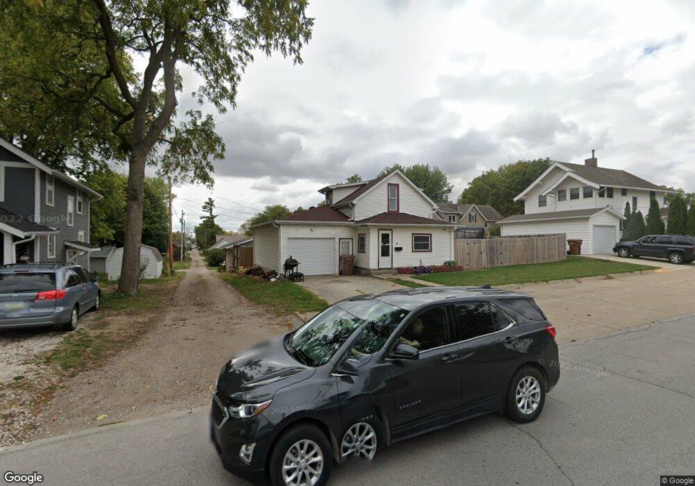
117 W 10th St Carroll, IA 51401
Estimated Value: $87,000 - $120,754
2
Beds
2
Baths
1,168
Sq Ft
$91/Sq Ft
Est. Value
About This Home
This home is located at 117 W 10th St, Carroll, IA 51401 and is currently estimated at $106,689, approximately $91 per square foot. 117 W 10th St is a home with nearby schools including Fairview Elementary School, Adams Elementary School, and Carroll Middle School.
Ownership History
Date
Name
Owned For
Owner Type
Purchase Details
Closed on
Dec 6, 2019
Sold by
Quetico Enterprises Inc
Bought by
Conroy Jacinda
Current Estimated Value
Home Financials for this Owner
Home Financials are based on the most recent Mortgage that was taken out on this home.
Original Mortgage
$82,613
Outstanding Balance
$72,835
Interest Rate
3.6%
Mortgage Type
Stand Alone Refi Refinance Of Original Loan
Estimated Equity
$33,854
Purchase Details
Closed on
Nov 22, 2017
Sold by
Quetico Enterprise Inc
Bought by
Conroy Jacinda
Create a Home Valuation Report for This Property
The Home Valuation Report is an in-depth analysis detailing your home's value as well as a comparison with similar homes in the area
Home Values in the Area
Average Home Value in this Area
Purchase History
| Date | Buyer | Sale Price | Title Company |
|---|---|---|---|
| Conroy Jacinda | $64,500 | None Available | |
| Conroy Jacinda | $64,500 | None Available | |
| Conroy Jacinda | -- | None Available |
Source: Public Records
Mortgage History
| Date | Status | Borrower | Loan Amount |
|---|---|---|---|
| Open | Conroy Jacinda | $82,613 | |
| Closed | Conroy Jacinda | $82,613 |
Source: Public Records
Tax History Compared to Growth
Tax History
| Year | Tax Paid | Tax Assessment Tax Assessment Total Assessment is a certain percentage of the fair market value that is determined by local assessors to be the total taxable value of land and additions on the property. | Land | Improvement |
|---|---|---|---|---|
| 2025 | $890 | $78,260 | $13,440 | $64,820 |
| 2024 | $890 | $69,260 | $13,440 | $55,820 |
| 2023 | $1,027 | $69,260 | $13,440 | $55,820 |
| 2022 | $972 | $67,000 | $11,200 | $55,800 |
| 2021 | $972 | $67,000 | $11,200 | $55,800 |
| 2020 | $1,000 | $67,000 | $11,200 | $55,800 |
| 2019 | $1,014 | $66,680 | $0 | $0 |
| 2018 | $956 | $66,680 | $0 | $0 |
| 2017 | $954 | $62,320 | $0 | $0 |
| 2016 | $892 | $62,320 | $0 | $0 |
| 2015 | $892 | $63,920 | $0 | $0 |
| 2014 | $904 | $63,920 | $0 | $0 |
Source: Public Records
Map
Nearby Homes
- 1015 N Adams St
- 926 N Court St
- 1102 N Main St
- 1108 N Main St
- 807 N Court St
- 204 W 11th St
- 1217 N Main St
- 1026 N Clark St
- 804 N Clark St
- 226 W 13th St
- 1036 N Crawford St
- 19383 U S 30
- 1408 N Adams St
- 0 Deer Creek Ln Unit 6302348
- 222 Bass St
- 1601 Pike Ave
- 260 Bass St
- 332 N Crawford St
- 907 Salinger Ave
- 621 Alta Vista Dr