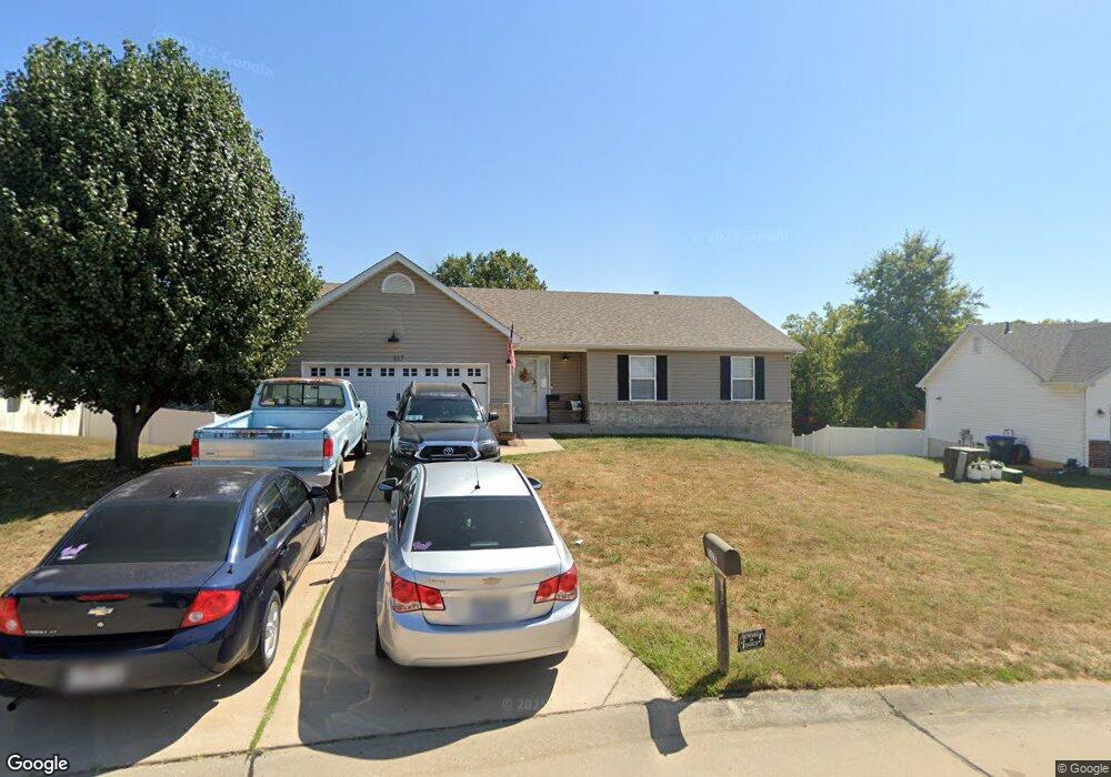
117 W Park Cir O Fallon, MO 63366
Estimated Value: $310,000 - $355,000
3
Beds
2
Baths
1,372
Sq Ft
$239/Sq Ft
Est. Value
About This Home
This home is located at 117 W Park Cir, O Fallon, MO 63366 and is currently estimated at $327,988, approximately $239 per square foot. 117 W Park Cir is a home located in St. Charles County with nearby schools including Joseph L. Mudd Elementary School, Forest Park Elementary School, and Fort Zumwalt West Middle School.
Ownership History
Date
Name
Owned For
Owner Type
Purchase Details
Closed on
Dec 16, 2021
Sold by
Anderson Joshua and Anderson Beth
Bought by
Rusin David and Rusin Catherine
Current Estimated Value
Home Financials for this Owner
Home Financials are based on the most recent Mortgage that was taken out on this home.
Original Mortgage
$279,000
Outstanding Balance
$256,157
Interest Rate
2.98%
Mortgage Type
VA
Estimated Equity
$71,831
Purchase Details
Closed on
Jun 8, 2004
Sold by
Jaeger Homes Inc
Bought by
Anderson Joshua
Home Financials for this Owner
Home Financials are based on the most recent Mortgage that was taken out on this home.
Original Mortgage
$120,820
Interest Rate
4.62%
Mortgage Type
Purchase Money Mortgage
Create a Home Valuation Report for This Property
The Home Valuation Report is an in-depth analysis detailing your home's value as well as a comparison with similar homes in the area
Home Values in the Area
Average Home Value in this Area
Purchase History
| Date | Buyer | Sale Price | Title Company |
|---|---|---|---|
| Rusin David | -- | None Listed On Document | |
| Anderson Joshua | $151,026 | Multiple |
Source: Public Records
Mortgage History
| Date | Status | Borrower | Loan Amount |
|---|---|---|---|
| Open | Rusin David | $279,000 | |
| Previous Owner | Anderson Joshua | $120,820 | |
| Closed | Anderson Joshua | $15,100 |
Source: Public Records
Tax History
| Year | Tax Paid | Tax Assessment Tax Assessment Total Assessment is a certain percentage of the fair market value that is determined by local assessors to be the total taxable value of land and additions on the property. | Land | Improvement |
|---|---|---|---|---|
| 2025 | $3,358 | $55,409 | -- | -- |
| 2023 | $3,359 | $50,671 | -- | -- |
| 2022 | $2,904 | $40,698 | $0 | $0 |
| 2021 | $2,906 | $40,698 | $0 | $0 |
| 2020 | $2,756 | $37,410 | $0 | $0 |
| 2019 | $2,763 | $37,410 | $0 | $0 |
| 2018 | $2,471 | $31,922 | $0 | $0 |
| 2017 | $2,435 | $31,922 | $0 | $0 |
| 2016 | $2,206 | $28,801 | $0 | $0 |
| 2015 | $2,051 | $28,801 | $0 | $0 |
| 2014 | $1,991 | $27,491 | $0 | $0 |
Source: Public Records
Map
Nearby Homes
- 151 N Wellington St
- 1234 Pinehurst Club Ct
- 962 Midpoint Dr
- 3 Pinehurst Forest Ct
- 8 Winter Forest Ct
- 10 Southern Hills Ct
- 11 Southern Hills Ct
- 159 Weatherby Landing Dr Unit 53
- 140 Weatherby Landing Dr
- 1117 Turtle Creek Dr
- 319 Magnolia Valley Dr
- 0 Montbrook Dr
- 217 Roaring River Dr
- 302 Birmingham Dr
- 532 Bramblett Hills
- 14 Spangle Way Dr
- 5 Challenger Ct
- 713 Plaza Dr
- 116 Columbia Meadows Ln
- 4 Challenger Ct
Your Personal Tour Guide
Ask me questions while you tour the home.