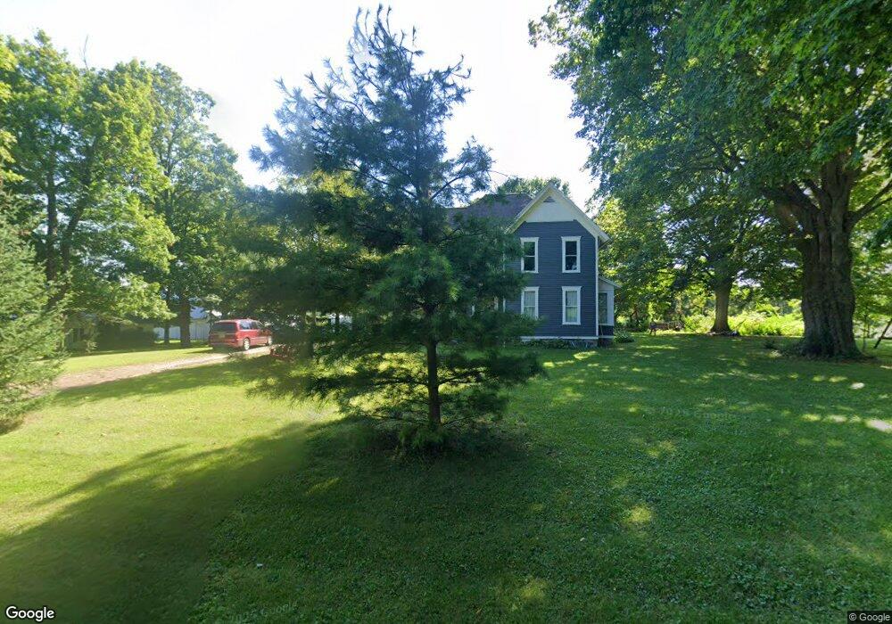
11700 22 Mile Rd Marshall, MI 49068
Estimated Value: $243,000 - $331,000
4
Beds
2
Baths
2,366
Sq Ft
$118/Sq Ft
Est. Value
About This Home
This home is located at 11700 22 Mile Rd, Marshall, MI 49068 and is currently estimated at $279,188, approximately $118 per square foot. 11700 22 Mile Rd is a home located in Calhoun County with nearby schools including New Albany Middle School and Cooks Prairie Baptist School.
Ownership History
Date
Name
Owned For
Owner Type
Purchase Details
Closed on
Dec 4, 2019
Sold by
Burr Oak Farms Inc
Bought by
Siebert Phillip and Siebert Christine
Current Estimated Value
Purchase Details
Closed on
Oct 16, 2007
Sold by
Kinney Marguerite G
Bought by
Burr Oak Farms Inc
Purchase Details
Closed on
May 30, 2007
Sold by
Rausch James G and Estate Of Gilbert L Rausch
Bought by
Rausch James G and Middleton Barbara A
Create a Home Valuation Report for This Property
The Home Valuation Report is an in-depth analysis detailing your home's value as well as a comparison with similar homes in the area
Home Values in the Area
Average Home Value in this Area
Purchase History
| Date | Buyer | Sale Price | Title Company |
|---|---|---|---|
| Siebert Phillip | -- | None Available | |
| Burr Oak Farms Inc | -- | None Available | |
| Kinney Marguerite G | $120,000 | None Available | |
| Rausch James G | -- | None Available |
Source: Public Records
Mortgage History
| Date | Status | Borrower | Loan Amount |
|---|---|---|---|
| Closed | Siebert Phillip | $0 |
Source: Public Records
Tax History Compared to Growth
Tax History
| Year | Tax Paid | Tax Assessment Tax Assessment Total Assessment is a certain percentage of the fair market value that is determined by local assessors to be the total taxable value of land and additions on the property. | Land | Improvement |
|---|---|---|---|---|
| 2025 | $2,330 | $89,010 | $0 | $0 |
| 2024 | $806 | $94,690 | $0 | $0 |
| 2023 | -- | $95,700 | $0 | $0 |
| 2022 | $731 | $67,320 | $0 | $0 |
| 2021 | $2,213 | $61,640 | $0 | $0 |
| 2020 | $2,213 | $64,740 | $0 | $0 |
| 2019 | $0 | $59,950 | $0 | $0 |
| 2018 | $0 | $49,720 | $7,920 | $41,800 |
| 2017 | $0 | $46,990 | $0 | $0 |
| 2016 | $0 | $40,900 | $0 | $0 |
| 2015 | -- | $41,340 | $19,116 | $22,224 |
| 2014 | -- | $41,200 | $19,116 | $22,084 |
Source: Public Records
Map
Nearby Homes
- 24 Mile Rd
- 308 State St
- 13976 20 Mile Rd
- 25270 B Dr S
- B Dr S Lot Unit WP001
- 0 Homer Rd
- 10505 18 1 2 Mile Rd
- 00000 17 1 2 Mile Rd
- VL Partello Rd
- 25160 F Dr N
- 808 Clinton St
- 741 Montgomery St
- Integrity 2080 Plan at Valley View
- integrity 1830 Plan at Valley View
- Integrity 1750 Plan at Valley View
- Integrity 2061 V8.1a Plan at Valley View
- Integrity 1880 Plan at Valley View
- Integrity 1520 Plan at Valley View
- Elements 2070 Plan at Valley View
- integrity 2280 Plan at Valley View
- 11641 22 Mile Rd
- 11601 22 Mile Rd
- 11581 22 Mile Rd
- 0 22 Mile Rd Unit M15050417
- 0 22 Mile Rd Unit 64015050417
- 0 22 Mile Rd Unit 64016010451
- 0 22 Mile Rd Unit 16010451
- 0 22 Mile Rd Unit PAR 3 3384877
- 0 22 Mile Rd Unit PAR 4
- 22140 Division Dr
- 11413 22 Mile Rd
- 22135 Division Dr
- 11350 22 Mile Rd
- 21995 Division Dr
- 21700 Division Dr
- 11295 22 Mile Rd
- 22417 B Dr S
- 11241 22 Mile Rd
- 11211 22 Mile Rd
- 21406 Division Dr