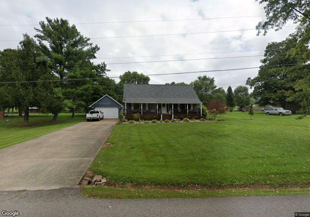
1171 Mill Branch Rd Belpre, OH 45714
Estimated Value: $242,287 - $278,000
3
Beds
3
Baths
1,519
Sq Ft
$171/Sq Ft
Est. Value
About This Home
This home is located at 1171 Mill Branch Rd, Belpre, OH 45714 and is currently estimated at $259,822, approximately $171 per square foot. 1171 Mill Branch Rd is a home located in Washington County with nearby schools including Belpre Elementary School and Belpre High School.
Ownership History
Date
Name
Owned For
Owner Type
Purchase Details
Closed on
Apr 19, 2013
Sold by
Mcclead Kathryn M and Mcclead Michael J
Bought by
Wilson Patrick Shayne
Current Estimated Value
Home Financials for this Owner
Home Financials are based on the most recent Mortgage that was taken out on this home.
Original Mortgage
$94,500
Outstanding Balance
$42,906
Interest Rate
3.5%
Mortgage Type
New Conventional
Estimated Equity
$216,916
Purchase Details
Closed on
Mar 26, 2001
Bought by
Mcclead Kathryn M and Mcclead Mic
Purchase Details
Closed on
Apr 1, 1999
Bought by
Janes Thomas M and Janes Trac
Purchase Details
Closed on
Aug 14, 1995
Bought by
Gilfillan Michael J and Gilfillan L
Purchase Details
Closed on
Aug 28, 1987
Create a Home Valuation Report for This Property
The Home Valuation Report is an in-depth analysis detailing your home's value as well as a comparison with similar homes in the area
Home Values in the Area
Average Home Value in this Area
Purchase History
| Date | Buyer | Sale Price | Title Company |
|---|---|---|---|
| Wilson Patrick Shayne | $130,000 | Attorney | |
| Mcclead Kathryn M | $121,500 | -- | |
| Mcclead Kathryn M | $121,500 | -- | |
| Janes Thomas M | $113,500 | -- | |
| Janes Thomas M | $113,500 | -- | |
| Gilfillan Michael J | $104,000 | -- | |
| Gilfillan Michael J | $104,000 | -- | |
| -- | $8,500 | -- | |
| -- | $8,500 | -- |
Source: Public Records
Mortgage History
| Date | Status | Borrower | Loan Amount |
|---|---|---|---|
| Open | Wilson Patrick Shayne | $94,500 |
Source: Public Records
Tax History
| Year | Tax Paid | Tax Assessment Tax Assessment Total Assessment is a certain percentage of the fair market value that is determined by local assessors to be the total taxable value of land and additions on the property. | Land | Improvement |
|---|---|---|---|---|
| 2024 | $3,803 | $63,730 | $9,190 | $54,540 |
| 2023 | $2,531 | $63,730 | $9,190 | $54,540 |
| 2022 | $2,518 | $63,730 | $9,190 | $54,540 |
| 2021 | $1,960 | $46,510 | $7,310 | $39,200 |
| 2020 | $1,846 | $46,510 | $7,310 | $39,200 |
| 2019 | $1,838 | $46,510 | $7,310 | $39,200 |
| 2018 | $1,781 | $43,550 | $6,090 | $37,460 |
| 2017 | $1,431 | $43,550 | $6,090 | $37,460 |
| 2016 | $2,184 | $43,550 | $6,090 | $37,460 |
| 2015 | $1,339 | $40,500 | $6,090 | $34,410 |
| 2014 | $2,035 | $40,500 | $6,090 | $34,410 |
| 2013 | $1,314 | $40,500 | $6,090 | $34,410 |
Source: Public Records
Map
Nearby Homes
- 155 Ridgewood Blvd
- 1948 State Route 339
- 240 Hollywood Dr
- 1310 Oxbow Rd
- 56 Carson Ln
- 120 Carson Ln
- 2526 Valley View Dr
- 1103 Farson St
- 2811 Washington Blvd
- 631 Short Brook Rd
- 2313 Washington Blvd
- 195 N Bruce St
- 111 T322
- 82 Highland Lake Cir
- 1806 Pennsylvania Ave
- 350 Blennerhassett Heights
- 2053 Mcgill Rd
- 1047 Lakewood Cir
- 906 Westview Dr
- 1621 Lakewood Cir
- 1171 T289
- 1149 Mill Branch Rd
- 1195 Mill Branch Rd
- 1271 Mill Branch Rd
- 1131 Mill Branch Rd
- 1160 Mill Branch Rd
- 1142 Mill Branch Rd
- 1226 Mill Branch Rd
- 1107 Mill Branch Rd
- 1103 Mill Branch Rd
- 533 Emmaus Rd
- 1311 Mill Branch Rd
- 501 Emmaus Rd
- 1072 Mill Branch Rd Unit T298
- 1645 Drag Strip Rd
- 550 Emmaus Rd
- 1111 Mill Branch Rd
- 469 Emmaus Rd
- 520 Emmaus Rd
- 1710 Drag Strip Rd
Your Personal Tour Guide
Ask me questions while you tour the home.