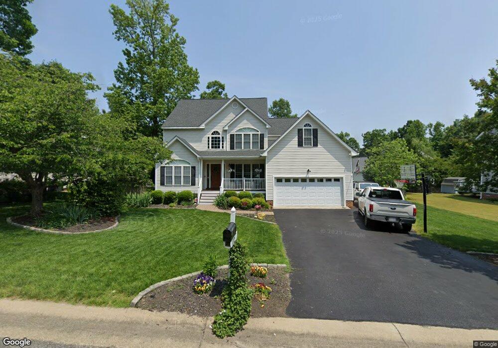
11712 Nevis Dr Midlothian, VA 23114
Estimated Value: $522,000 - $548,000
4
Beds
3
Baths
2,599
Sq Ft
$204/Sq Ft
Est. Value
About This Home
This home is located at 11712 Nevis Dr, Midlothian, VA 23114 and is currently estimated at $530,521, approximately $204 per square foot. 11712 Nevis Dr is a home located in Chesterfield County with nearby schools including W W Gordon Elementary School, Midlothian Middle School, and Monacan High School.
Ownership History
Date
Name
Owned For
Owner Type
Purchase Details
Closed on
Mar 23, 2001
Sold by
Enterprise Builders/Devel Llc
Bought by
Russell Timothy A and Russell Laura B
Current Estimated Value
Home Financials for this Owner
Home Financials are based on the most recent Mortgage that was taken out on this home.
Original Mortgage
$203,000
Outstanding Balance
$73,420
Interest Rate
6.93%
Mortgage Type
VA
Estimated Equity
$457,101
Create a Home Valuation Report for This Property
The Home Valuation Report is an in-depth analysis detailing your home's value as well as a comparison with similar homes in the area
Home Values in the Area
Average Home Value in this Area
Purchase History
| Date | Buyer | Sale Price | Title Company |
|---|---|---|---|
| Russell Timothy A | $200,500 | -- |
Source: Public Records
Mortgage History
| Date | Status | Borrower | Loan Amount |
|---|---|---|---|
| Open | Russell Timothy A | $203,000 |
Source: Public Records
Tax History Compared to Growth
Tax History
| Year | Tax Paid | Tax Assessment Tax Assessment Total Assessment is a certain percentage of the fair market value that is determined by local assessors to be the total taxable value of land and additions on the property. | Land | Improvement |
|---|---|---|---|---|
| 2025 | $4,491 | $501,800 | $72,000 | $429,800 |
| 2024 | $4,491 | $467,500 | $67,000 | $400,500 |
| 2023 | $3,995 | $439,000 | $65,000 | $374,000 |
| 2022 | $3,634 | $395,000 | $62,000 | $333,000 |
| 2021 | $3,341 | $349,100 | $60,000 | $289,100 |
| 2020 | $3,316 | $349,100 | $60,000 | $289,100 |
| 2019 | $3,188 | $335,600 | $60,000 | $275,600 |
| 2018 | $3,089 | $325,200 | $60,000 | $265,200 |
| 2017 | $2,901 | $302,200 | $60,000 | $242,200 |
| 2016 | $2,838 | $295,600 | $60,000 | $235,600 |
| 2015 | $2,727 | $281,500 | $60,000 | $221,500 |
| 2014 | $2,715 | $280,200 | $60,000 | $220,200 |
Source: Public Records
Map
Nearby Homes
- 11625 Nevis Dr
- 1009 Woodlet Meadow Ln
- 1418 Crawford Wood Place
- 1002 Wedgemont Place
- 11907 Exbury Ct
- 1526 Crawford Wood Dr
- 11933 Exbury Terrace
- 11950 Lucks Ln
- 11960 Lucks Ln
- 11301 Mansfield Crossing Ct
- 11970 Lucks Ln
- 1606 Bantry Loop
- 1842 Bantry Dr
- 1937 Bantry Dr
- 914 Spirea Rd
- 11205 Lantern Way Unit B
- 1712 Porters Mill Ln
- 11120 Pennway Dr
- 11312 McCauliff Ct
- 11101 Pennway Dr
- 11718 Nevis Dr
- 11706 Nevis Dr
- 11713 Duxbury Ct
- 11707 Duxbury Ct
- 11719 Duxbury Ct
- 11724 Nevis Dr
- 11713 Nevis Dr
- 11700 Nevis Dr
- 11719 Nevis Dr
- 11707 Nevis Dr
- 11725 Duxbury Ct
- 11725 Nevis Dr
- 11701 Nevis Dr
- 11700 Duxbury Ct
- 11730 Nevis Dr
- 11700 Moven Dr
- 11712 Moven Dr
- 11731 Nevis Dr
- 11731 Duxbury Ct
- 11706 Duxbury Ct