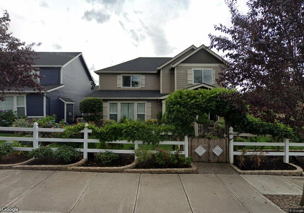
11732 Hazelnut Ave Oregon City, OR 97045
Hazel Grove-Westling Farm NeighborhoodEstimated Value: $588,571 - $620,000
3
Beds
3
Baths
2,044
Sq Ft
$296/Sq Ft
Est. Value
About This Home
This home is located at 11732 Hazelnut Ave, Oregon City, OR 97045 and is currently estimated at $605,143, approximately $296 per square foot. 11732 Hazelnut Ave is a home located in Clackamas County with nearby schools including John McLoughlin Elementary School, Gardiner Middle School, and Oregon City Senior High School.
Ownership History
Date
Name
Owned For
Owner Type
Purchase Details
Closed on
May 15, 2007
Sold by
Cj Custom Homes Llc
Bought by
Schroeder Dennis and Schroeder Dorothy A
Current Estimated Value
Home Financials for this Owner
Home Financials are based on the most recent Mortgage that was taken out on this home.
Original Mortgage
$326,777
Outstanding Balance
$198,443
Interest Rate
6.14%
Mortgage Type
VA
Estimated Equity
$406,700
Create a Home Valuation Report for This Property
The Home Valuation Report is an in-depth analysis detailing your home's value as well as a comparison with similar homes in the area
Home Values in the Area
Average Home Value in this Area
Purchase History
| Date | Buyer | Sale Price | Title Company |
|---|---|---|---|
| Schroeder Dennis | $319,900 | Transnation Title Agency Or |
Source: Public Records
Mortgage History
| Date | Status | Borrower | Loan Amount |
|---|---|---|---|
| Open | Schroeder Dennis | $326,777 |
Source: Public Records
Tax History Compared to Growth
Tax History
| Year | Tax Paid | Tax Assessment Tax Assessment Total Assessment is a certain percentage of the fair market value that is determined by local assessors to be the total taxable value of land and additions on the property. | Land | Improvement |
|---|---|---|---|---|
| 2024 | $4,968 | $296,079 | -- | -- |
| 2023 | $4,968 | $287,456 | $0 | $0 |
| 2022 | $4,571 | $279,084 | $0 | $0 |
| 2021 | $4,388 | $270,956 | $0 | $0 |
| 2020 | $4,262 | $263,065 | $0 | $0 |
| 2019 | $4,172 | $255,403 | $0 | $0 |
| 2018 | $3,965 | $247,964 | $0 | $0 |
| 2017 | $3,862 | $240,742 | $0 | $0 |
| 2016 | $3,792 | $233,730 | $0 | $0 |
| 2015 | $3,696 | $226,922 | $0 | $0 |
| 2014 | $3,591 | $220,313 | $0 | $0 |
Source: Public Records
Map
Nearby Homes
- 19477 Hummingbird Loop
- 19370 Westwood Dr
- 19457 Sunset Springs Dr
- 19149 S End Rd
- 19338 Inishbride Ct
- 11300 Finnegans Way
- 19600 S End Rd
- 11231 S Parkland Ct
- 18969 Lafayette Ave
- 18843 Chanelle Way
- 19327 Reddaway Ave
- 19108 Sunrise Way
- 19693 Leland Rd
- 0 S End Rd
- 19157 Gentry Highlands Ln
- 12618 Villard Place
- 19144 Gentry Highlands Ln
- 11427 Sprite Way
- 12795 Lindsay Anne Ln
- 12708 Aspenwood Ln
- 11744 Hazelnut Ave
- 19461 Hummingbird Loop
- 19469 Hummingbird Loop
- 11758 Hazelnut Ave
- 19449 S Vincent Dr
- 19500 Hummingbird Loop
- 11770 Hazelnut Ave
- 11671 Hazelnut Ave
- 11671 Hazelnut Ave
- 19504 Hummingbird Loop
- 11751 Hazelnut Ave
- 19448 Aspen Ridge Ct
- 19508 Hummingbird Loop
- 11751 Hazelnut Ave
- 11794 Hazelnut Ave
- 19445 S Vincent Dr
- 19444 Aspen Ridge Ct
- 19485 Hummingbird Loop
- 19512 Hummingbird Loop
- 19493 Hummingbird Loop