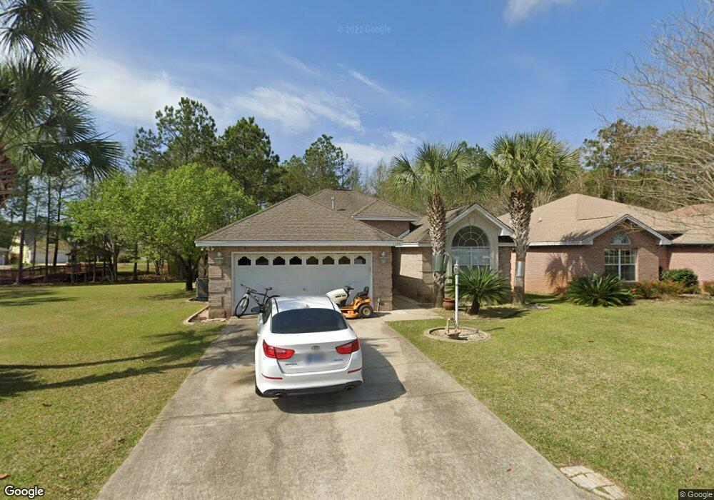
1176 Brookridge Trace Fort Walton Beach, FL 32547
Wright NeighborhoodEstimated Value: $389,172 - $398,000
3
Beds
2
Baths
1,683
Sq Ft
$234/Sq Ft
Est. Value
About This Home
This home is located at 1176 Brookridge Trace, Fort Walton Beach, FL 32547 and is currently estimated at $393,293, approximately $233 per square foot. 1176 Brookridge Trace is a home located in Okaloosa County with nearby schools including Longwood Elementary School, W.C. Pryor Middle School, and Choctawhatchee Senior High School.
Ownership History
Date
Name
Owned For
Owner Type
Purchase Details
Closed on
Jul 9, 2021
Sold by
Curry Terry D and Thomas Curry Marsha
Bought by
Curry Terry D and Thomas Curry Marsha
Current Estimated Value
Home Financials for this Owner
Home Financials are based on the most recent Mortgage that was taken out on this home.
Original Mortgage
$207,000
Outstanding Balance
$187,992
Interest Rate
2.96%
Mortgage Type
New Conventional
Estimated Equity
$205,301
Purchase Details
Closed on
Aug 20, 2018
Sold by
Boling Johnny V and Boling Joy F
Bought by
Curry Terry D and Thomas Curry Marsha J
Create a Home Valuation Report for This Property
The Home Valuation Report is an in-depth analysis detailing your home's value as well as a comparison with similar homes in the area
Home Values in the Area
Average Home Value in this Area
Purchase History
| Date | Buyer | Sale Price | Title Company |
|---|---|---|---|
| Curry Terry D | -- | Panhandle Title Inc | |
| Curry Terry D | $85,000 | Panhandle Title Inc |
Source: Public Records
Mortgage History
| Date | Status | Borrower | Loan Amount |
|---|---|---|---|
| Open | Curry Terry D | $207,000 | |
| Closed | Curry Terry D | $0 |
Source: Public Records
Tax History Compared to Growth
Tax History
| Year | Tax Paid | Tax Assessment Tax Assessment Total Assessment is a certain percentage of the fair market value that is determined by local assessors to be the total taxable value of land and additions on the property. | Land | Improvement |
|---|---|---|---|---|
| 2024 | $1,072 | $134,448 | -- | -- |
| 2023 | $1,072 | $130,532 | $0 | $0 |
| 2022 | $1,035 | $126,730 | $0 | $0 |
| 2021 | $1,023 | $123,039 | $0 | $0 |
| 2020 | $1,010 | $121,340 | $0 | $0 |
| 2019 | $990 | $118,612 | $0 | $0 |
| 2018 | $974 | $116,400 | $0 | $0 |
| 2017 | $951 | $114,006 | $0 | $0 |
| 2016 | $924 | $111,661 | $0 | $0 |
| 2015 | $933 | $110,885 | $0 | $0 |
| 2014 | $926 | $110,005 | $0 | $0 |
Source: Public Records
Map
Nearby Homes
- 1942 Woodcrest Ridge Unit 2
- 1956 Woodcrest Ridge
- 1810 Scirocco Loop
- 1961 Chesapeake Ridge
- 1602 Mariah Way E
- 606 Lee St
- 1905 Mistral Ln W
- 1100 Crosswinds Landing Unit 14
- 1100 Crosswinds Landing Unit 19
- 1100 Crosswinds Landing Unit 21
- 816 Lark St Unit 5, 6, 7, 8
- 818 Lark St Unit 1, 2, 3, 4
- 765 Pine Alley St
- 850 Holbrook Cir
- 508 Parkview Rd NW Unit A, B & C
- 518 Parkview Rd NW Unit A
- 940 Central Ave Unit 15
- 1002 Hondo Ave
- 941 Ashley Ln Unit D
- 1013 Gloria Ave
- 1179 Brookridge Trace
- 1184 Brookridge Trace
- 1182 Cathridge Trace
- 0 Brookridge Trace
- 1181 Brookridge Trace
- 1950 Procteridge Ct
- 1186 Brookridge Trace
- 1184 Cathridge Trace
- 1187 Cathridge Trace
- 1174 Witshire Ct
- 1176 Witshire Ct
- 1185 Witshire Ct
- 1195 Cathridge Trace
- 1188 Brookridge Trace
- 1951 Procteridge Ct
- 1178 Witshire Ct
- 1180 Witshire Ct
- 1185 Jamescross Ct
- 1187 Witshire Ct
- 1182 Witshire Ct