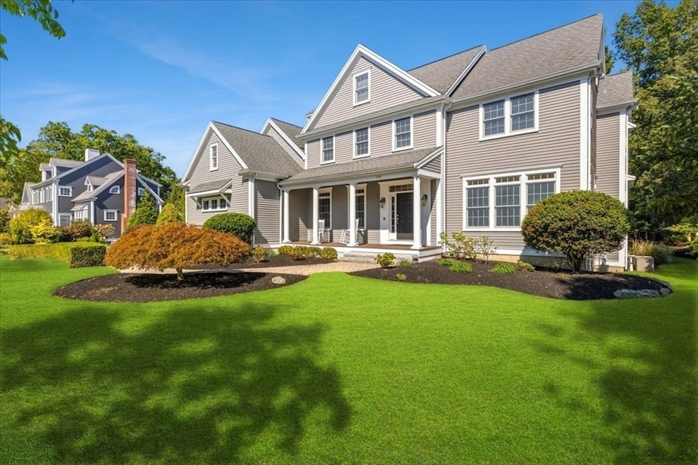
118 Bates Way Hanover, MA 02339
Estimated payment $10,236/month
Highlights
- Golf Course Community
- Home Theater
- Custom Closet System
- Hanover High School Rated 9+
- Open Floorplan
- Colonial Architecture
About This Home
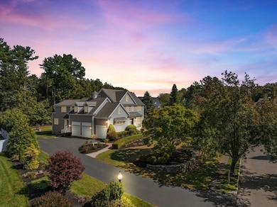
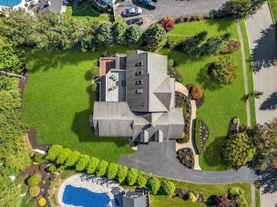
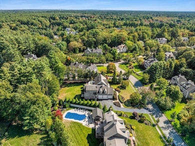
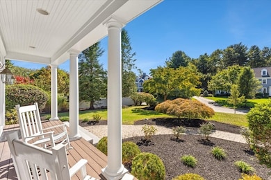
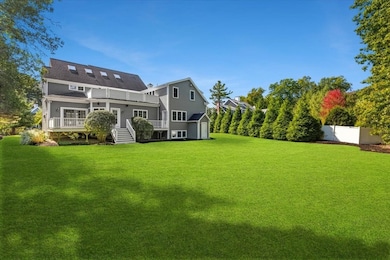
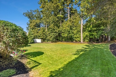
Welcome to 118 Bates Way, a stunning 5-bedroom, 4.5-bath retreat in Hanover’s prestigious Stone Meadow neighborhood. This 5,867 sq. ft. residence, built in 2002, features an open-concept main level, perfect for entertaining, which includes a gourmet kitchen with granite countertops, a grand great room with custom built-ins, a gas fireplace, and a formal dining room with a coffered ceiling. The luxurious primary suite on the second floor includes a spa-inspired bathroom with soaking tub and fireplace. A bonus room & secluded home office with built in bookcases complete the upper levels. A main-floor in-law suite offers convenience for extended family or live in help. A bright, unfinished walkout basement is just waiting for your customization. Outside, enjoy a tree-lined backyard with a large deck and ample lawn space for a future pool. This stunning home is near scenic walking trails, top-rated schools, shopping, & major highways, providing an ideal blend of luxury & convenience
Home Details
Home Type
- Single Family
Est. Annual Taxes
- $21,448
Year Built
- Built in 2002
Lot Details
- 0.71 Acre Lot
- Landscaped Professionally
- Level Lot
- Sprinkler System
- Cleared Lot
HOA Fees
- $33 Monthly HOA Fees
Parking
- 3 Car Attached Garage
- Garage Door Opener
- Driveway
- Open Parking
- Off-Street Parking
Home Design
- Colonial Architecture
- Frame Construction
- Shingle Roof
- Concrete Perimeter Foundation
Interior Spaces
- 5,867 Sq Ft Home
- Open Floorplan
- Central Vacuum
- Wired For Sound
- Crown Molding
- Coffered Ceiling
- Skylights
- Recessed Lighting
- Decorative Lighting
- Light Fixtures
- Insulated Windows
- Window Screens
- French Doors
- Sliding Doors
- Insulated Doors
- Living Room with Fireplace
- 2 Fireplaces
- Sitting Room
- Dining Area
- Home Theater
- Home Office
- Game Room
Kitchen
- Breakfast Bar
- Oven
- Range with Range Hood
- Microwave
- Dishwasher
- Wine Refrigerator
- Wine Cooler
- Stainless Steel Appliances
- Kitchen Island
- Solid Surface Countertops
Flooring
- Wood
- Wall to Wall Carpet
- Ceramic Tile
Bedrooms and Bathrooms
- 5 Bedrooms
- Fireplace in Primary Bedroom
- Primary bedroom located on second floor
- Custom Closet System
- Walk-In Closet
- Maid or Guest Quarters
- Fireplace in Bathroom
- Dual Vanity Sinks in Primary Bathroom
- Soaking Tub
- Bathtub with Shower
- Separate Shower
- Linen Closet In Bathroom
Laundry
- Laundry on upper level
- Dryer
- Washer
Unfinished Basement
- Walk-Out Basement
- Basement Fills Entire Space Under The House
- Interior and Exterior Basement Entry
- Sump Pump
- Block Basement Construction
Outdoor Features
- Balcony
- Deck
- Outdoor Storage
- Rain Gutters
- Porch
Schools
- Hanover Middle School
- Hanover High School
Utilities
- Forced Air Heating and Cooling System
- 5 Cooling Zones
- 5 Heating Zones
- Heating System Uses Natural Gas
- Radiant Heating System
- 200+ Amp Service
- Gas Water Heater
- Sewer Inspection Required for Sale
Additional Features
- Energy-Efficient Thermostat
- Property is near schools
Listing and Financial Details
- Assessor Parcel Number M:21 L:121,4231308
Community Details
Overview
- Stone Meadow Subdivision
- Near Conservation Area
Amenities
- Shops
Recreation
- Golf Course Community
- Park
- Jogging Path
Map
Home Values in the Area
Average Home Value in this Area
Tax History
| Year | Tax Paid | Tax Assessment Tax Assessment Total Assessment is a certain percentage of the fair market value that is determined by local assessors to be the total taxable value of land and additions on the property. | Land | Improvement |
|---|---|---|---|---|
| 2025 | $21,448 | $1,736,700 | $337,300 | $1,399,400 |
| 2024 | $20,534 | $1,599,200 | $337,300 | $1,261,900 |
| 2023 | $20,583 | $1,525,800 | $306,600 | $1,219,200 |
| 2022 | $18,320 | $1,201,300 | $269,800 | $931,500 |
| 2021 | $18,294 | $1,120,300 | $245,200 | $875,100 |
| 2020 | $17,992 | $1,103,100 | $267,500 | $835,600 |
| 2019 | $17,375 | $1,058,800 | $278,600 | $780,200 |
| 2018 | $16,275 | $999,700 | $298,700 | $701,000 |
| 2017 | $16,545 | $1,001,500 | $271,500 | $730,000 |
| 2016 | $16,186 | $960,000 | $246,900 | $713,100 |
| 2015 | $15,504 | $960,000 | $246,900 | $713,100 |
Property History
| Date | Event | Price | List to Sale | Price per Sq Ft |
|---|---|---|---|---|
| 10/13/2025 10/13/25 | For Sale | $1,599,900 | 0.0% | $273 / Sq Ft |
| 10/05/2025 10/05/25 | Pending | -- | -- | -- |
| 09/30/2025 09/30/25 | For Sale | $1,599,900 | -- | $273 / Sq Ft |
Purchase History
| Date | Type | Sale Price | Title Company |
|---|---|---|---|
| Quit Claim Deed | -- | None Available | |
| Quit Claim Deed | -- | None Available | |
| Quit Claim Deed | -- | None Available | |
| Quit Claim Deed | $700,000 | None Available | |
| Quit Claim Deed | $700,000 | None Available | |
| Quit Claim Deed | $700,000 | None Available | |
| Deed | $1,269,000 | -- | |
| Deed | $345,000 | -- | |
| Deed | $210,000 | -- | |
| Deed | $1,269,000 | -- | |
| Deed | $345,000 | -- |
Mortgage History
| Date | Status | Loan Amount | Loan Type |
|---|---|---|---|
| Previous Owner | $995,000 | Purchase Money Mortgage | |
| Previous Owner | $147,000 | No Value Available |
Source: MLS Property Information Network (MLS PIN)
MLS Number: 73437490
APN: HANO-000021-000000-000121
Disclaimer: Certain information contained herein is derived from information provided by parties other than Homes.com. All information provided is deemed reliable, but is not guaranteed to be accurate and should be independently verified.
![]() The property listing data and information, or the Images, set forth herein were provided to MLS Property Information Network, Inc. from third party sources, including sellers, lessors and public records, and were compiled by MLS Property Information Network, Inc. The property listing data and information, and the Images, are for the personal, non-commercial use of consumers having a good faith interest in purchasing or leasing listed properties of the type displayed to them and may not be used for any purpose other than to identify prospective properties which such consumers may have a good faith interest in purchasing or leasing. MLS Property Information Network, Inc. and its subscribers disclaim any and all representations and warranties as to the accuracy of the property listing data and information, or as to the accuracy of any of the Images, set forth herein.
The property listing data and information, or the Images, set forth herein were provided to MLS Property Information Network, Inc. from third party sources, including sellers, lessors and public records, and were compiled by MLS Property Information Network, Inc. The property listing data and information, and the Images, are for the personal, non-commercial use of consumers having a good faith interest in purchasing or leasing listed properties of the type displayed to them and may not be used for any purpose other than to identify prospective properties which such consumers may have a good faith interest in purchasing or leasing. MLS Property Information Network, Inc. and its subscribers disclaim any and all representations and warranties as to the accuracy of the property listing data and information, or as to the accuracy of any of the Images, set forth herein.
- 983 Webster St
- 1015 Webster St
- 216 Whiting St
- 375 Webster St
- 1239 Main St
- 53 Chestnut St
- 276 Woodland Dr
- 1 Corn Mill Way
- 62 Larchmont Ln
- 5 Corn Mill Way
- 1225 Hanover St
- 80 Coolidge Rd
- 116 Spring Meadow Ln
- 141 Deerfield Ln
- 4 Phillips St
- 436 E Water St
- 718 Market St
- 354 Webster St
- 7 Assinippi Ave Unit 216
- 7 Assinippi Ave Unit 306
- 295 Webster St
- 80 Mill St
- 9 Pleasant View Park
- 26 Wheeler Ave Unit 1
- 23 Sunnyside Ave Unit 3T
- 292 Market St
- 42 Church St Unit 16
- 15 High St
- 346 Union St Unit 7
- 37 Linden St Unit 2
- 466 Center St Unit 2
- 466 Center St Unit C
- 103 Grove St Unit 337
- 198 Reed St Unit 3
- 51 Maple St
- 511-525 Washington St
- 135 Grove St Unit 140
- 369 Washington St
- 102 Central St Unit 2
- 880 Plymouth St Unit B
