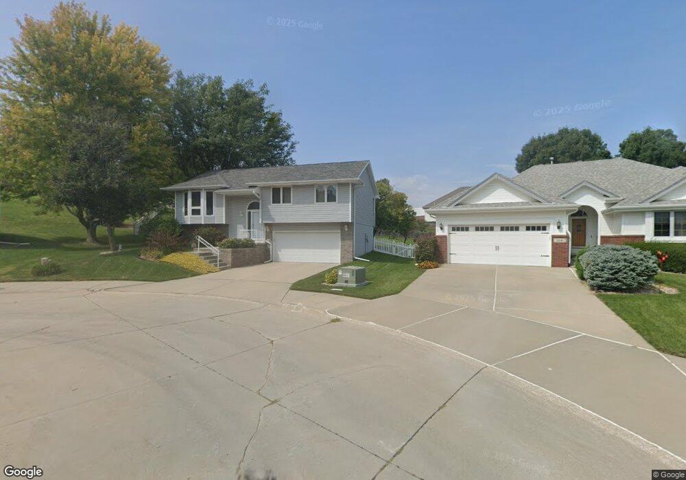
118 Fenwick Cir Council Bluffs, IA 51503
Eastern Council Bluffs NeighborhoodEstimated Value: $325,000 - $340,000
3
Beds
3
Baths
1,479
Sq Ft
$226/Sq Ft
Est. Value
About This Home
This home is located at 118 Fenwick Cir, Council Bluffs, IA 51503 and is currently estimated at $333,538, approximately $225 per square foot. 118 Fenwick Cir is a home located in Pottawattamie County with nearby schools including E.A. Kreft Primary School, Titan Hill Intermediate School, and Lewis Central Middle School.
Ownership History
Date
Name
Owned For
Owner Type
Purchase Details
Closed on
Nov 22, 2011
Sold by
Taylor Philip G and Taylor Kimberly K
Bought by
Eret Ty Joseph and Eret Marcy Lynn
Current Estimated Value
Home Financials for this Owner
Home Financials are based on the most recent Mortgage that was taken out on this home.
Original Mortgage
$59,500
Outstanding Balance
$23,759
Interest Rate
4.11%
Mortgage Type
New Conventional
Estimated Equity
$309,779
Create a Home Valuation Report for This Property
The Home Valuation Report is an in-depth analysis detailing your home's value as well as a comparison with similar homes in the area
Home Values in the Area
Average Home Value in this Area
Purchase History
| Date | Buyer | Sale Price | Title Company |
|---|---|---|---|
| Eret Ty Joseph | $169,500 | None Available |
Source: Public Records
Mortgage History
| Date | Status | Borrower | Loan Amount |
|---|---|---|---|
| Open | Eret Ty Joseph | $59,500 |
Source: Public Records
Tax History Compared to Growth
Tax History
| Year | Tax Paid | Tax Assessment Tax Assessment Total Assessment is a certain percentage of the fair market value that is determined by local assessors to be the total taxable value of land and additions on the property. | Land | Improvement |
|---|---|---|---|---|
| 2025 | $4,488 | $287,100 | $53,900 | $233,200 |
| 2024 | $4,488 | $261,400 | $46,900 | $214,500 |
| 2023 | $4,342 | $261,400 | $46,900 | $214,500 |
| 2022 | $3,954 | $204,600 | $45,900 | $158,700 |
| 2021 | $6,038 | $204,600 | $45,900 | $158,700 |
| 2020 | $3,654 | $204,600 | $45,900 | $158,700 |
| 2019 | $3,804 | $174,100 | $39,734 | $134,366 |
| 2018 | $3,716 | $174,100 | $39,734 | $134,366 |
| 2017 | $3,784 | $174,100 | $39,734 | $134,366 |
| 2015 | $3,754 | $175,816 | $39,734 | $136,082 |
| 2014 | $3,776 | $175,816 | $39,734 | $136,082 |
Source: Public Records
Map
Nearby Homes
- 212 Woodcliff Cir
- 206 Parkview Dr
- 310 Wildwood Rd
- 200 Timber Dr
- 208 Red Bud Ln
- 2526 Franklin Ave
- 1715 Blackthorn St
- 128 Charles Park Dr
- 1711 Blackthorn St
- LOT 12 Mcpherson Ave
- 1742 Blackthorn St
- 1759 Blackthorn St
- 131 Norwood Dr
- 1768 Blackthorn St
- 1835 Balsam St
- 16090 Crystal Ln
- 1873 Hemlock St
- 1893 Hemlock St
- 1847 Balsam St
- 1780 Blackthorn St
- 114 Fenwick Cir
- 122 Fenwick Cir
- 427 Cloverdale Dr
- 431 Cloverdale Dr
- 423 Cloverdale Dr
- 409 Timber Dr
- 110 Fenwick Cir
- 419 Cloverdale Dr
- 123 Fenwick Cir
- 405 Timber Dr
- 106 Marinda Dr
- 115 Fenwick Cir
- 119 Fenwick Cir
- 401 Timber Dr
- 111 Fenwick Cir
- 422 Cloverdale Dr
- 315 Timber Dr
- 107 Fenwick Cir
- 422 Cloverdale Dr
- 332 Cloverdale Dr