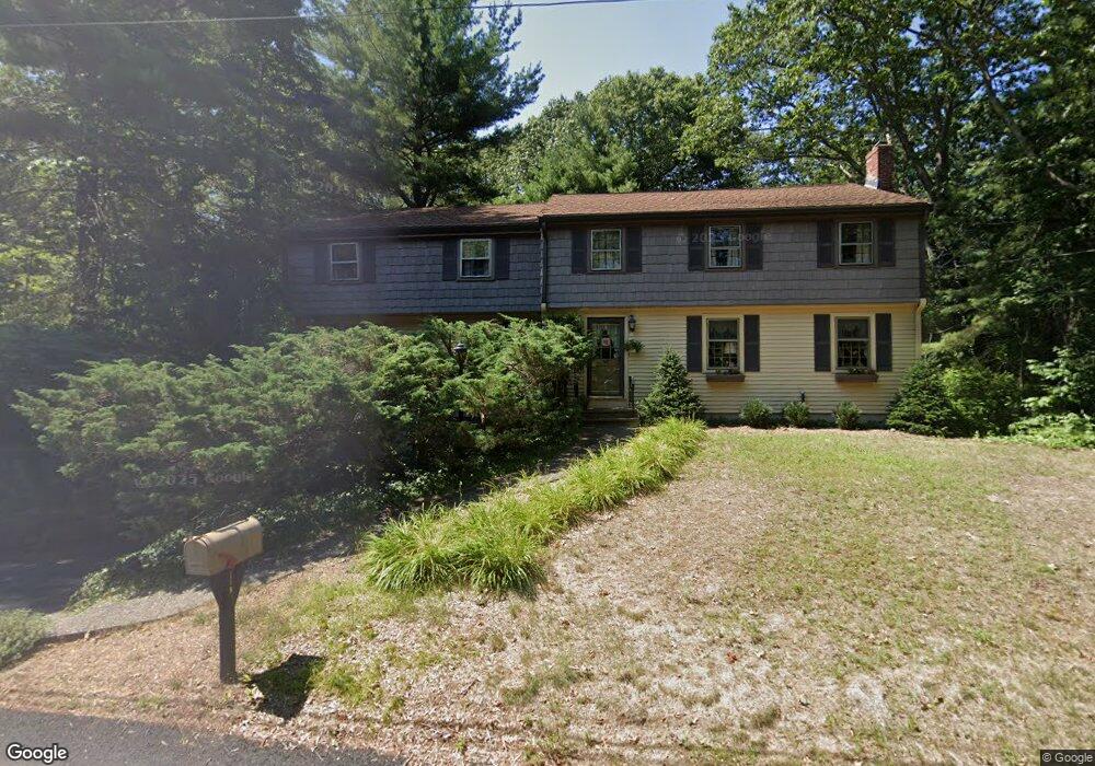
118 Larson Rd Stoughton, MA 02072
Estimated Value: $709,000 - $786,000
5
Beds
3
Baths
3,333
Sq Ft
$222/Sq Ft
Est. Value
About This Home
This home is located at 118 Larson Rd, Stoughton, MA 02072 and is currently estimated at $740,273, approximately $222 per square foot. 118 Larson Rd is a home located in Norfolk County with nearby schools including Joseph R Dawe Jr Elementary School, O'Donnell Middle School, and Stoughton High School.
Ownership History
Date
Name
Owned For
Owner Type
Purchase Details
Closed on
Dec 12, 2023
Sold by
Graber Arlene and Graber D S
Bought by
S David & A J Graber Ft and Graber
Current Estimated Value
Purchase Details
Closed on
Aug 4, 1969
Bought by
Graber S David and Graber Arlene
Create a Home Valuation Report for This Property
The Home Valuation Report is an in-depth analysis detailing your home's value as well as a comparison with similar homes in the area
Home Values in the Area
Average Home Value in this Area
Purchase History
| Date | Buyer | Sale Price | Title Company |
|---|---|---|---|
| S David & A J Graber Ft | -- | None Available | |
| S David & A J Graber Ft | -- | None Available | |
| Graber S David | -- | -- |
Source: Public Records
Tax History
| Year | Tax Paid | Tax Assessment Tax Assessment Total Assessment is a certain percentage of the fair market value that is determined by local assessors to be the total taxable value of land and additions on the property. | Land | Improvement |
|---|---|---|---|---|
| 2025 | $7,317 | $591,000 | $222,200 | $368,800 |
| 2024 | $7,105 | $558,100 | $203,000 | $355,100 |
| 2023 | $6,980 | $515,100 | $185,500 | $329,600 |
| 2022 | $6,800 | $471,900 | $178,500 | $293,400 |
| 2021 | $6,496 | $430,200 | $157,500 | $272,700 |
| 2020 | $6,313 | $424,000 | $157,500 | $266,500 |
| 2019 | $6,159 | $401,500 | $157,500 | $244,000 |
| 2018 | $5,509 | $372,000 | $150,500 | $221,500 |
| 2017 | $5,305 | $366,100 | $148,700 | $217,400 |
| 2016 | $5,028 | $335,900 | $134,700 | $201,200 |
| 2015 | $4,976 | $328,900 | $127,700 | $201,200 |
| 2014 | $4,905 | $311,600 | $117,200 | $194,400 |
Source: Public Records
Map
Nearby Homes
- 870 Turnpike St
- 42 Brewster Rd Unit 42
- 121 Bassick Cir
- Lot 3 Lawler Ln
- 362 Lincoln St
- 25 Lawler Ln
- 15 Lawler Ln
- 631 Page St
- 19 Camelot Ct
- 503 Page St
- 15 First St
- 1 Bruce St
- 292 Prospect St
- 36 Pleasant Dr Unit 42
- 882 Park St
- 28 Walnut Terrace
- 47 Trowbridge Cir
- Lot 2 Pondview Ln
- Lot 43 Pondview Ln
- 58 Union St Unit 6
Your Personal Tour Guide
Ask me questions while you tour the home.