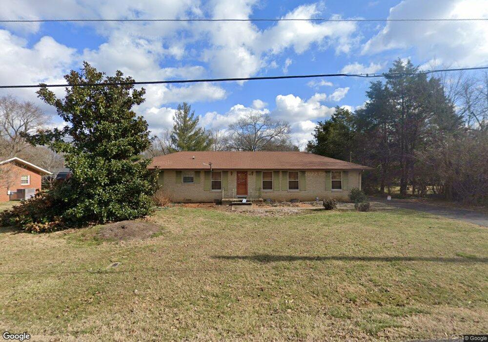
118 Mcfarlin Rd Murfreesboro, TN 37130
Estimated Value: $286,869 - $373,000
Studio
2
Baths
1,600
Sq Ft
$217/Sq Ft
Est. Value
About This Home
This home is located at 118 Mcfarlin Rd, Murfreesboro, TN 37130 and is currently estimated at $347,217, approximately $217 per square foot. 118 Mcfarlin Rd is a home located in Rutherford County with nearby schools including Kittrell Elementary School, Whitworth-Buchanan Middle School, and Oakland High School.
Ownership History
Date
Name
Owned For
Owner Type
Purchase Details
Closed on
Jan 22, 2009
Sold by
Beasley Jimmie A
Bought by
West Kristen
Current Estimated Value
Home Financials for this Owner
Home Financials are based on the most recent Mortgage that was taken out on this home.
Original Mortgage
$151,210
Outstanding Balance
$95,832
Interest Rate
5.23%
Estimated Equity
$251,385
Purchase Details
Closed on
Aug 10, 2006
Sold by
Webb D R
Bought by
Beasley Jimmie A and Beasley Cheryl
Create a Home Valuation Report for This Property
The Home Valuation Report is an in-depth analysis detailing your home's value as well as a comparison with similar homes in the area
Home Values in the Area
Average Home Value in this Area
Purchase History
| Date | Buyer | Sale Price | Title Company |
|---|---|---|---|
| West Kristen | $154,000 | -- | |
| Beasley Jimmie A | $130,000 | -- | |
| Beasley Jimmie A | $130,000 | -- |
Source: Public Records
Mortgage History
| Date | Status | Borrower | Loan Amount |
|---|---|---|---|
| Open | Beasley Jimmie A | $151,210 |
Source: Public Records
Tax History
| Year | Tax Paid | Tax Assessment Tax Assessment Total Assessment is a certain percentage of the fair market value that is determined by local assessors to be the total taxable value of land and additions on the property. | Land | Improvement |
|---|---|---|---|---|
| 2025 | $1,117 | $59,550 | $13,750 | $45,800 |
| 2024 | $1,117 | $59,550 | $13,750 | $45,800 |
| 2023 | $1,129 | $60,150 | $13,750 | $46,400 |
| 2022 | $972 | $60,150 | $13,750 | $46,400 |
| 2021 | $837 | $39,875 | $8,250 | $31,625 |
| 2020 | $885 | $39,875 | $8,250 | $31,625 |
| 2019 | $885 | $39,875 | $8,250 | $31,625 |
| 2018 | $837 | $39,875 | $0 | $0 |
| 2017 | $823 | $30,725 | $0 | $0 |
| 2016 | $823 | $30,725 | $0 | $0 |
| 2015 | $823 | $30,725 | $0 | $0 |
| 2014 | $764 | $30,725 | $0 | $0 |
| 2013 | -- | $29,600 | $0 | $0 |
Source: Public Records
Map
Nearby Homes
- 2519 E Main St
- 5485 John Bragg Hwy
- 2815 E Main St
- 531 Dill Ln Unit A9
- 2961 S Rutherford Blvd Unit A1
- 600 Twin Oak Dr
- 1814 Dr Martin Luther King jr Blvd
- 1810 Dr Martin Luther King jr Blvd
- 133 Copper Hollow Dr
- 1014 Gleaning Ct
- 1006 Gleaning Ct
- 1017 Gleaning Ct
- 1013 Gleaning Ct
- 1010 Gleaning Ct
- 806 Brookfield Dr
- 2215 Haven Dr
- 904 Empire Blvd
- 620 Thrush Place
- 908 Empire Blvd
- 912 Empire Blvd
- 122 Mcfarlin Rd
- 114 Mcfarlin Rd
- 119 Juliet Ave
- 115 Juliet Ave Unit 117
- 115 Mcfarlin Rd
- 119 Mcfarlin Rd
- 126 Mcfarlin Rd
- 110 Mcfarlin Rd
- 111 Juliet Ave Unit 113
- 123 Mcfarlin Rd
- 111 Mcfarlin Rd
- 2404 Anchor St
- 127 Juliet Ave
- 2408 Anchor St
- 130 Mcfarlin Rd
- 107 Juliet Ave Unit 109
- 118 Juliet Ave
- 127 Mcfarlin Rd
- 114 Juliet Ave
- 122 Juliet Ave
Your Personal Tour Guide
Ask me questions while you tour the home.