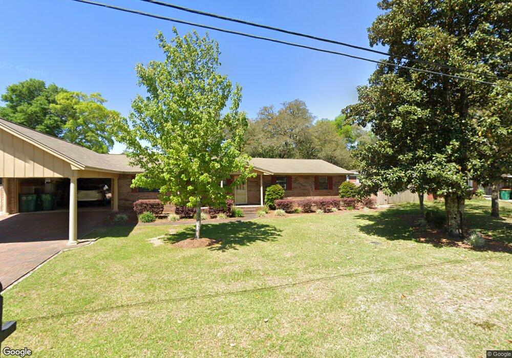
118 Michael Ave Fort Walton Beach, FL 32547
Wright NeighborhoodEstimated Value: $330,000 - $433,000
3
Beds
2
Baths
2,346
Sq Ft
$166/Sq Ft
Est. Value
About This Home
This home is located at 118 Michael Ave, Fort Walton Beach, FL 32547 and is currently estimated at $389,354, approximately $165 per square foot. 118 Michael Ave is a home located in Okaloosa County with nearby schools including Longwood Elementary School, W.C. Pryor Middle School, and Choctawhatchee Senior High School.
Ownership History
Date
Name
Owned For
Owner Type
Purchase Details
Closed on
Nov 21, 2016
Sold by
Grimes Bryan O and Grimes Mary K
Bought by
Grimes Bryan and Brian Grimes Revocable Trust
Current Estimated Value
Purchase Details
Closed on
Mar 5, 2013
Sold by
Grimes Bryan O and Grimes Mary K
Bought by
Grimes Bryan O and Grimes Mary K
Purchase Details
Closed on
Nov 17, 2004
Sold by
Grimes Connie R
Bought by
Grimes Bryan O and Grimes Connie R
Create a Home Valuation Report for This Property
The Home Valuation Report is an in-depth analysis detailing your home's value as well as a comparison with similar homes in the area
Home Values in the Area
Average Home Value in this Area
Purchase History
| Date | Buyer | Sale Price | Title Company |
|---|---|---|---|
| Grimes Bryan | -- | Attorney | |
| Grimes Bryan O | -- | None Available | |
| Grimes Bryan O | -- | -- |
Source: Public Records
Tax History Compared to Growth
Tax History
| Year | Tax Paid | Tax Assessment Tax Assessment Total Assessment is a certain percentage of the fair market value that is determined by local assessors to be the total taxable value of land and additions on the property. | Land | Improvement |
|---|---|---|---|---|
| 2024 | $1,592 | $172,563 | -- | -- |
| 2023 | $1,592 | $167,537 | $0 | $0 |
| 2022 | $1,546 | $162,657 | $0 | $0 |
| 2021 | $1,536 | $157,919 | $0 | $0 |
| 2020 | $1,520 | $155,739 | $0 | $0 |
| 2019 | $1,496 | $152,238 | $0 | $0 |
| 2018 | $1,389 | $142,635 | $0 | $0 |
| 2017 | $1,361 | $139,701 | $0 | $0 |
| 2016 | $1,294 | $134,595 | $0 | $0 |
| 2015 | $1,307 | $133,659 | $0 | $0 |
| 2014 | $1,298 | $132,598 | $0 | $0 |
Source: Public Records
Map
Nearby Homes
- 413 Gerold St
- 401 Gerold St
- 706 Mary Ave
- 6 Chelsea Dr NW
- 16 Chelsea Dr NW
- 2392 Cummings Dr
- 603 Bob Sikes Blvd
- 801 Playground Rd
- 526 Cheshire Ave NW
- 926 Lois St
- 528 Cheshire Ave NW
- 503 Newcastle Dr
- 619 Spencer Dr
- 24 Cinderella Ln NW
- 20 Linwood Rd NW
- 605 Colonial Dr Unit 2
- 611 Colonial Dr Unit 6
- 605 Colonial Dr Unit 4
- 609 Colonial Dr Unit 2
- 615 Colonial Dr Unit 1
- 116 Michael Ave
- 120 Michael Ave
- 114 Michael Ave
- 119 Michael Ave
- 121 Michael Ave
- 115 Michael Ave
- 122 Michael Ave
- 112 Michael Ave
- 714 Bob Sikes Blvd
- 123 Michael Ave
- 110 Michael Ave
- 113 Michael Ave
- 802 Pinedale Rd
- 810 Pinedale Rd
- 108 Michael Ave
- 800 Pinedale Rd
- 111 Truxton Ave Unit C
- 116 Truxton Ave
- 812 Pinedale Rd
- 111 Michael Ave