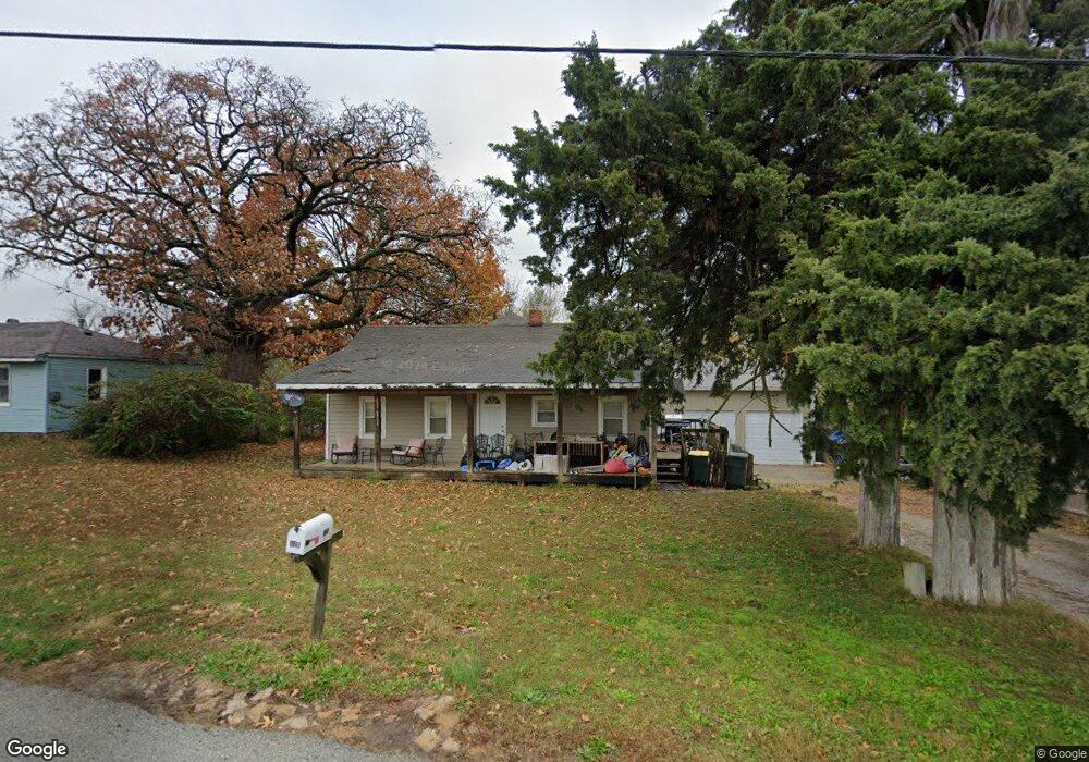
118 W Kay St Lansing, KS 66043
Estimated Value: $180,000 - $203,000
2
Beds
1
Bath
1,160
Sq Ft
$165/Sq Ft
Est. Value
About This Home
This home is located at 118 W Kay St, Lansing, KS 66043 and is currently estimated at $191,469, approximately $165 per square foot. 118 W Kay St is a home located in Leavenworth County with nearby schools including Lansing Elementary School, Lansing Middle 6-8, and Lansing High 9-12.
Ownership History
Date
Name
Owned For
Owner Type
Purchase Details
Closed on
Sep 1, 2002
Bought by
Dickason Michael J
Current Estimated Value
Home Financials for this Owner
Home Financials are based on the most recent Mortgage that was taken out on this home.
Original Mortgage
$65,000
Outstanding Balance
$46,747
Interest Rate
6.22%
Mortgage Type
New Conventional
Estimated Equity
$144,722
Create a Home Valuation Report for This Property
The Home Valuation Report is an in-depth analysis detailing your home's value as well as a comparison with similar homes in the area
Home Values in the Area
Average Home Value in this Area
Purchase History
| Date | Buyer | Sale Price | Title Company |
|---|---|---|---|
| Dickason Michael J | $40,000 | -- |
Source: Public Records
Mortgage History
| Date | Status | Borrower | Loan Amount |
|---|---|---|---|
| Open | Dickason Michael J | $65,000 |
Source: Public Records
Tax History Compared to Growth
Tax History
| Year | Tax Paid | Tax Assessment Tax Assessment Total Assessment is a certain percentage of the fair market value that is determined by local assessors to be the total taxable value of land and additions on the property. | Land | Improvement |
|---|---|---|---|---|
| 2025 | $1,997 | $16,681 | $2,023 | $14,658 |
| 2024 | $1,890 | $15,590 | $2,023 | $13,567 |
| 2023 | $1,890 | $14,991 | $1,921 | $13,070 |
| 2022 | $1,818 | $13,628 | $1,709 | $11,919 |
| 2021 | $1,884 | $13,264 | $1,709 | $11,555 |
| 2020 | $1,711 | $11,881 | $1,709 | $10,172 |
| 2019 | $1,654 | $11,477 | $1,709 | $9,768 |
| 2018 | $1,454 | $10,135 | $1,709 | $8,426 |
| 2017 | $1,275 | $8,902 | $1,709 | $7,193 |
| 2016 | $1,262 | $8,814 | $1,709 | $7,105 |
| 2015 | $1,241 | $8,695 | $1,709 | $6,986 |
| 2014 | $1,215 | $8,695 | $1,709 | $6,986 |
Source: Public Records
Map
Nearby Homes
- 202 S Main St
- 124 S Main St
- 527 S Valley Dr
- 129 Crestview Ct
- 104 Olive St
- 20958 Ida St
- 218 E Kay St
- 129 Brookwood St
- 306 E Kay St
- 310 E Kansas Ave
- 522 Forestglen Ln
- 546 Hithergreen Dr
- 415 Fairlane St
- 268 Holiday Dr
- 521 Hillbrook Dr
- 922 Southfork St
- 811 4-H Rd
- 542 Creekside Ct
- 1102 N Main St
- 1100 N 4th St