Estimated Value: $184,351 - $216,000
2
Beds
2
Baths
1,280
Sq Ft
$154/Sq Ft
Est. Value
About This Home
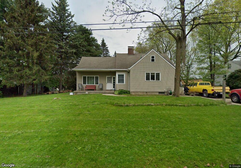
This home is located at 1181 Hampton Rd, Kent, OH 44240 and is currently estimated at $196,838, approximately $153 per square foot. 1181 Hampton Rd is a home located in Portage County with nearby schools including Longcoy Elementary School, Stanton Middle School, and Theodore Roosevelt High School.
Ownership History
Date
Name
Owned For
Owner Type
Purchase Details
Closed on
Dec 16, 2021
Sold by
Stewart Thomas E
Bought by
Kurtz Jason
Current Estimated Value
Home Financials for this Owner
Home Financials are based on the most recent Mortgage that was taken out on this home.
Original Mortgage
$107,460
Outstanding Balance
$97,828
Interest Rate
3.12%
Mortgage Type
FHA
Estimated Equity
$99,010
Purchase Details
Closed on
Jan 1, 1990
Bought by
Stewart Harold T
Create a Home Valuation Report for This Property
The Home Valuation Report is an in-depth analysis detailing your home's value as well as a comparison with similar homes in the area
Home Values in the Area
Average Home Value in this Area
Purchase History
| Date | Buyer | Sale Price | Title Company |
|---|---|---|---|
| Kurtz Jason | -- | Simon William G | |
| Stewart Harold T | -- | -- |
Source: Public Records
Mortgage History
| Date | Status | Borrower | Loan Amount |
|---|---|---|---|
| Open | Kurtz Jason | $107,460 |
Source: Public Records
Tax History
| Year | Tax Paid | Tax Assessment Tax Assessment Total Assessment is a certain percentage of the fair market value that is determined by local assessors to be the total taxable value of land and additions on the property. | Land | Improvement |
|---|---|---|---|---|
| 2025 | $2,781 | $61,010 | $7,880 | $53,130 |
| 2024 | $2,737 | $61,010 | $7,880 | $53,130 |
| 2023 | $2,757 | $48,870 | $7,880 | $40,990 |
| 2022 | $2,719 | $48,200 | $7,880 | $40,320 |
| 2021 | $2,805 | $48,200 | $7,880 | $40,320 |
| 2020 | $2,606 | $39,630 | $7,880 | $31,750 |
| 2019 | $2,540 | $39,630 | $7,880 | $31,750 |
| 2018 | $1,699 | $34,100 | $7,880 | $26,220 |
| 2017 | $1,699 | $34,100 | $7,880 | $26,220 |
| 2016 | $1,695 | $34,100 | $7,880 | $26,220 |
| 2015 | $1,695 | $34,100 | $7,880 | $26,220 |
| 2014 | $1,724 | $34,100 | $7,880 | $26,220 |
| 2013 | $1,711 | $34,100 | $7,880 | $26,220 |
Source: Public Records
Map
Nearby Homes
- 1165 Hampton Rd
- 350 Silver Meadows Blvd
- 1245 Chelton Dr
- 458 Irma St
- 1189 Garth Dr
- 1330 Chelton Dr
- 1285 Gale Dr
- 876 Middlebury Rd
- 1138 Lower Dr
- 726 Hughey Dr
- 895 Highridge Ln
- 3313 Crown Pointe Dr
- 957 Edgewater Cir Unit 20
- 614 Pioneer St
- 0 Middlebury Rd
- 994 Erin Dr
- 1067 Erin Dr
- 3209 Pimlico Blvd
- 1302 Walnut St
- 3474 Churchill Downs
- 415 S Francis St
- 413 S Francis St
- 1173 Hampton Rd
- 1180 W Main St
- 1184 Hampton Rd
- 1180 Hampton Rd
- 1176 Hampton Rd
- 1188 Hampton Rd
- 1172 Hampton Rd
- 427 S Francis St
- 1166 Hampton Rd
- 433 S Francis St
- 1157 Hampton Rd
- 402 S Francis St
- 435 S Francis St
- 1170 W Main St
- 1191 Leonard Blvd
- 1185 Leonard Blvd
- 1197 Leonard Blvd
- 1160 Hampton Rd
Your Personal Tour Guide
Ask me questions while you tour the home.