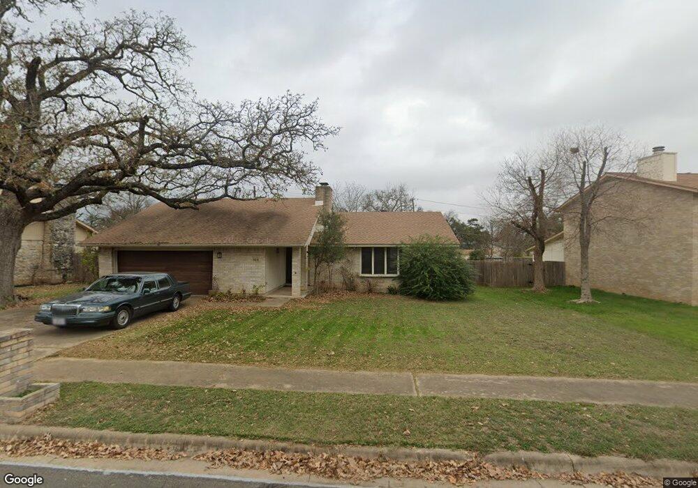
11814 Rustle Ln Austin, TX 78750
Anderson Mill NeighborhoodEstimated Value: $417,985 - $516,000
--
Bed
2
Baths
1,870
Sq Ft
$247/Sq Ft
Est. Value
About This Home
This home is located at 11814 Rustle Ln, Austin, TX 78750 and is currently estimated at $461,246, approximately $246 per square foot. 11814 Rustle Ln is a home located in Williamson County with nearby schools including Anderson Mill Elementary School, Noel Grisham Middle, and Westwood High School.
Ownership History
Date
Name
Owned For
Owner Type
Purchase Details
Closed on
Oct 7, 2008
Sold by
Fernandez Christine
Bought by
Fernandez Christopher and Fernandez Christopher Michael
Current Estimated Value
Home Financials for this Owner
Home Financials are based on the most recent Mortgage that was taken out on this home.
Original Mortgage
$153,600
Outstanding Balance
$100,008
Interest Rate
6%
Mortgage Type
Credit Line Revolving
Estimated Equity
$361,238
Create a Home Valuation Report for This Property
The Home Valuation Report is an in-depth analysis detailing your home's value as well as a comparison with similar homes in the area
Home Values in the Area
Average Home Value in this Area
Purchase History
| Date | Buyer | Sale Price | Title Company |
|---|---|---|---|
| Fernandez Christopher | -- | First American Title |
Source: Public Records
Mortgage History
| Date | Status | Borrower | Loan Amount |
|---|---|---|---|
| Open | Fernandez Christopher | $153,600 |
Source: Public Records
Tax History
| Year | Tax Paid | Tax Assessment Tax Assessment Total Assessment is a certain percentage of the fair market value that is determined by local assessors to be the total taxable value of land and additions on the property. | Land | Improvement |
|---|---|---|---|---|
| 2025 | $7,171 | $412,160 | $88,500 | $323,660 |
| 2024 | $7,171 | $431,050 | $88,500 | $342,550 |
| 2023 | $6,760 | $415,468 | $0 | $0 |
| 2022 | $8,110 | $377,698 | $0 | $0 |
| 2021 | $8,435 | $343,362 | $72,000 | $274,852 |
| 2020 | $7,427 | $312,147 | $66,598 | $245,549 |
| 2019 | $7,507 | $306,897 | $60,700 | $246,197 |
| 2018 | $6,655 | $293,817 | $54,891 | $238,926 |
| 2017 | $6,690 | $268,010 | $51,300 | $258,922 |
| 2016 | $6,081 | $243,645 | $51,300 | $226,040 |
| 2015 | $4,874 | $221,495 | $42,100 | $186,425 |
| 2014 | $4,874 | $201,359 | $0 | $0 |
Source: Public Records
Map
Nearby Homes
- 11000 Opal Trail
- 10810 Calcite Trail
- 12103 Grey Rock Ln
- 1028 Verbena Dr Unit 1144
- 11535 Sandy Loam Trail
- 11602 Crosstimber Dr
- 10404 Mourning Dove Dr
- 11100 Alison Parke Trail
- 11808 Buggy Whip Trail
- 12106 Grey Fawn Path
- 11905 Millwright Pkwy
- 11215 Slippery Elm Trail
- 10244 Missel Thrush Dr
- 10229 Missel Thrush Dr
- 11302 Centennial Trail
- 12208 Double Tree Ln
- 12300 Double Tree Ln
- 12301 Double Tree Ln
- 11318 Bristle Oak Trail
- 12114 Scissortail Dr
- 11900 Rustle Ln
- 11812 Rustle Ln
- 10704 Doering Ln
- 11902 Rustle Ln
- 11810 Rustle Ln
- 11901 Rustle Ln
- 10702 Doering Ln
- 11903 Rustle Ln
- 11904 Rustle Ln
- 11808 Rustle Ln
- 11807 Rustle Ln
- 11900 Pecan Creek Pkwy
- 10801 Marble Rd
- 11905 Rustle Ln
- 10707 Doering Ln
- 11802 Rust Rd
- 11800 Rust Rd
- 11804 Rust Rd
- 10801 Hard Rock Rd
- 11806 Rustle Ln