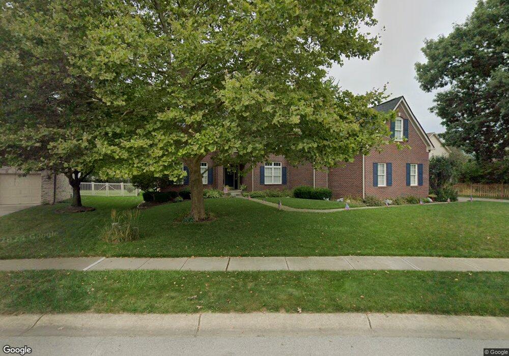
11878 Silverado Dr Fishers, IN 46037
Estimated Value: $564,000 - $618,000
--
Bed
4
Baths
3,380
Sq Ft
$176/Sq Ft
Est. Value
About This Home
This home is located at 11878 Silverado Dr, Fishers, IN 46037 and is currently estimated at $594,574, approximately $175 per square foot. 11878 Silverado Dr is a home located in Hamilton County with nearby schools including Hickok Elementary School, Brooks School Elementary School, and Fall Creek Intermediate School.
Ownership History
Date
Name
Owned For
Owner Type
Purchase Details
Closed on
Dec 19, 2000
Sold by
The Estridge Group Inc
Bought by
Dillow Brian D and Dillow Amy J
Current Estimated Value
Home Financials for this Owner
Home Financials are based on the most recent Mortgage that was taken out on this home.
Original Mortgage
$255,000
Outstanding Balance
$94,444
Interest Rate
7.77%
Estimated Equity
$500,130
Create a Home Valuation Report for This Property
The Home Valuation Report is an in-depth analysis detailing your home's value as well as a comparison with similar homes in the area
Home Values in the Area
Average Home Value in this Area
Purchase History
| Date | Buyer | Sale Price | Title Company |
|---|---|---|---|
| Dillow Brian D | -- | -- |
Source: Public Records
Mortgage History
| Date | Status | Borrower | Loan Amount |
|---|---|---|---|
| Open | Dillow Brian D | $255,000 |
Source: Public Records
Tax History Compared to Growth
Tax History
| Year | Tax Paid | Tax Assessment Tax Assessment Total Assessment is a certain percentage of the fair market value that is determined by local assessors to be the total taxable value of land and additions on the property. | Land | Improvement |
|---|---|---|---|---|
| 2024 | $5,259 | $472,900 | $82,000 | $390,900 |
| 2023 | $5,259 | $454,900 | $82,000 | $372,900 |
| 2022 | $5,007 | $416,300 | $82,000 | $334,300 |
| 2021 | $4,237 | $352,700 | $82,000 | $270,700 |
| 2020 | $4,440 | $365,000 | $84,900 | $280,100 |
| 2019 | $4,252 | $349,800 | $62,700 | $287,100 |
| 2018 | $3,968 | $326,000 | $62,700 | $263,300 |
| 2017 | $3,935 | $328,700 | $62,700 | $266,000 |
| 2016 | $3,874 | $324,700 | $62,700 | $262,000 |
| 2014 | $3,324 | $306,500 | $62,700 | $243,800 |
| 2013 | $3,324 | $309,300 | $62,700 | $246,600 |
Source: Public Records
Map
Nearby Homes
- 12230 Cobblestone Dr
- 11579 Townsend Ct
- 12307 Chiseled Stone Dr
- 12337 River Valley Dr
- 12036 Weathered Edge Dr
- 12218 Weathered Edge Dr
- 11581 Ludlow Dr
- 11318 Talon Trace
- 11517 Moss Rock Ct
- 12430 Hyacinth Dr
- 11346 Talnuck Cir
- 11502 Hearthstone Dr
- 12864 Hanley Dr
- 11101 Hawthorn Ridge
- 11932 Hollyhock Dr
- 12641 Chiefs Ct
- 10982 Brooks School Rd
- 12635 Touchdown Dr
- 10990 Brooks School Rd
- 12604 Brooks School Rd
- 11858 Silverado Dr
- 12115 Volcanic Rock Dr
- 12135 Volcanic Rock Dr
- 12095 Volcanic Rock Dr
- 11703 Seville Rd
- 11838 Silverado Dr
- 11879 Silverado Dr
- 12195 Volcanic Rock Dr
- 12194 Volcanic Rock Dr
- 11859 Silverado Dr
- 11895 Silverado Dr
- 12062 Cholla Rd
- 12075 Volcanic Rock Dr
- 11839 Silverado Dr
- 11693 Seville Rd
- 11818 Silverado Dr
- 11911 Silverado Dr
- 11926 Silverado Dr
- 11819 Silverado Dr
- 12055 Volcanic Rock Dr