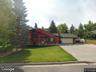
119 Aspen Grove Dr W Evanston, WY 82930
Estimated Value: $341,314 - $540,000
3
Beds
2
Baths
1,576
Sq Ft
$259/Sq Ft
Est. Value
About This Home
This home is located at 119 Aspen Grove Dr W, Evanston, WY 82930 and is currently estimated at $408,579, approximately $259 per square foot. 119 Aspen Grove Dr W is a home located in Uinta County with nearby schools including Evanston High School and Evanston Child Development Center.
Ownership History
Date
Name
Owned For
Owner Type
Purchase Details
Closed on
Mar 30, 2007
Sold by
Canen David Monroe and Canen Aileen
Bought by
Reichenberg David A and Reichenberg Candice R
Current Estimated Value
Home Financials for this Owner
Home Financials are based on the most recent Mortgage that was taken out on this home.
Original Mortgage
$196,800
Interest Rate
5.21%
Mortgage Type
New Conventional
Purchase Details
Closed on
Mar 27, 2006
Sold by
White James D and White Julie Ann
Bought by
Canen Aileen and Canen David Monroe
Home Financials for this Owner
Home Financials are based on the most recent Mortgage that was taken out on this home.
Original Mortgage
$176,000
Interest Rate
6.22%
Mortgage Type
New Conventional
Create a Home Valuation Report for This Property
The Home Valuation Report is an in-depth analysis detailing your home's value as well as a comparison with similar homes in the area
Home Values in the Area
Average Home Value in this Area
Purchase History
| Date | Buyer | Sale Price | Title Company |
|---|---|---|---|
| Reichenberg David A | -- | None Available | |
| Canen Aileen | -- | None Available |
Source: Public Records
Mortgage History
| Date | Status | Borrower | Loan Amount |
|---|---|---|---|
| Open | Reichenberg David A | $230,548 | |
| Previous Owner | Reichenberg David A | $247,000 | |
| Previous Owner | Reichenberg David A | $196,800 | |
| Previous Owner | Reichenberg David R | $49,200 | |
| Previous Owner | Canen David Monrol | $176,000 | |
| Previous Owner | Canen Aileen | $44,000 | |
| Previous Owner | White Julie Ann | $40,000 |
Source: Public Records
Tax History Compared to Growth
Tax History
| Year | Tax Paid | Tax Assessment Tax Assessment Total Assessment is a certain percentage of the fair market value that is determined by local assessors to be the total taxable value of land and additions on the property. | Land | Improvement |
|---|---|---|---|---|
| 2024 | $1,979 | $29,112 | $4,357 | $24,755 |
| 2023 | $2,082 | $30,785 | $4,144 | $26,641 |
| 2022 | $1,762 | $25,877 | $2,416 | $23,461 |
| 2021 | $1,500 | $22,000 | $2,416 | $19,584 |
| 2020 | $1,293 | $18,979 | $2,200 | $16,779 |
| 2019 | $1,221 | $17,958 | $2,057 | $15,901 |
| 2018 | $1,326 | $16,547 | $2,105 | $14,442 |
| 2017 | $1,112 | $16,368 | $2,105 | $14,263 |
| 2016 | $1,177 | $17,304 | $1,848 | $15,456 |
| 2015 | -- | $15,665 | $1,594 | $14,071 |
| 2014 | -- | $17,153 | $0 | $0 |
Source: Public Records
Map
Nearby Homes
- 106 Grandview
- 104 Windy Ridge Ct
- 213 Grandview
- 104 Canyon Hollow Dr
- 132 Skyline Dr
- 240 Darby Ln
- 260 Darby Ln
- 114 Carriage Dr
- 103 Alecias Way
- 218 Vista Ridge Cir
- 149 Toponce Dr
- 109 City View Dr
- 252 Jared Ln
- 132 Silver Sage Dr
- 130 Silver Sage Dr
- 48 Aspen Grove Dr W
- 249 Aspen Hills Ct
- 723 Sioux Dr
- 147 Apache Dr
- 203 Cheyenne Dr
- 119 Aspen Grove Dr W
- 117 Aspen Grove Dr W
- 121 Aspen Grove Dr W
- 116 Briarwood Ct
- 116 Briarwood Ct Unit Brook Hollow Dr
- 114 Briarwood Ct
- 118 Aspen Grove Dr W
- 120 Aspen Grove Dr W
- 120 Aspen Grove Dr W Unit Hwy 150
- 118 Briarwood Ct
- 118 Briarwood Ct Unit Brookhollow
- 116 Aspen Grove Dr W
- 116 Aspen Grove Dr W Unit West
- 102 Brookhollow Dr
- 102 Brookhollow Dr Unit Aspen Grove Drive
- 122 Aspen Grove Dr W
- 120 Briarwood Ct
- 112 Briarwood Ct
- 104 Grand View Cir
- 115 Aspen Grove Dr W