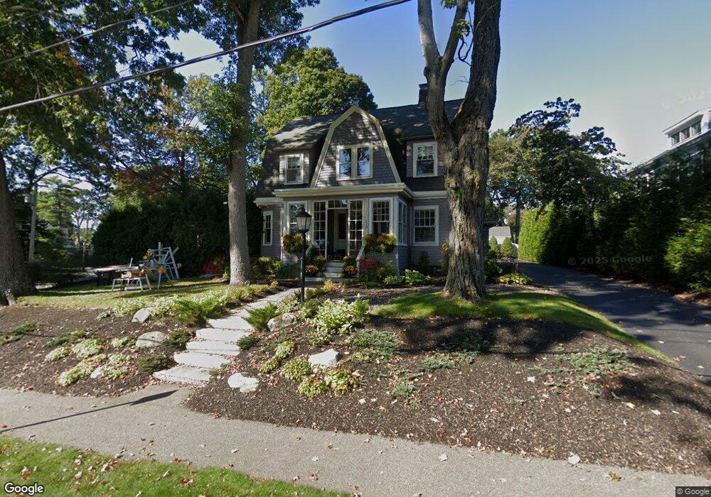
119 Bradford St Needham, MA 02492
Estimated Value: $1,719,000 - $1,961,000
4
Beds
2
Baths
3,348
Sq Ft
$536/Sq Ft
Est. Value
About This Home
This home is located at 119 Bradford St, Needham, MA 02492 and is currently estimated at $1,794,260, approximately $535 per square foot. 119 Bradford St is a home located in Norfolk County with nearby schools including Broadmeadow Elementary School, High Rock Middle School, and Pollard Middle School.
Ownership History
Date
Name
Owned For
Owner Type
Purchase Details
Closed on
Feb 27, 2003
Sold by
Levine Cindy B and Levine William M
Bought by
Pascucci Philip H and Pascucci Suzanne M
Current Estimated Value
Create a Home Valuation Report for This Property
The Home Valuation Report is an in-depth analysis detailing your home's value as well as a comparison with similar homes in the area
Home Values in the Area
Average Home Value in this Area
Purchase History
| Date | Buyer | Sale Price | Title Company |
|---|---|---|---|
| Pascucci Philip H | $646,000 | -- | |
| Pascucci Philip H | $646,000 | -- |
Source: Public Records
Mortgage History
| Date | Status | Borrower | Loan Amount |
|---|---|---|---|
| Open | Pascucci Philip H | $414,000 | |
| Closed | Pascucci Philip H | $437,600 |
Source: Public Records
Tax History Compared to Growth
Tax History
| Year | Tax Paid | Tax Assessment Tax Assessment Total Assessment is a certain percentage of the fair market value that is determined by local assessors to be the total taxable value of land and additions on the property. | Land | Improvement |
|---|---|---|---|---|
| 2025 | $15,776 | $1,488,300 | $1,005,500 | $482,800 |
| 2024 | $14,378 | $1,148,400 | $649,000 | $499,400 |
| 2023 | $14,437 | $1,107,100 | $649,000 | $458,100 |
| 2022 | $13,928 | $1,041,700 | $595,800 | $445,900 |
| 2021 | $13,338 | $1,023,600 | $595,800 | $427,800 |
| 2020 | $12,562 | $1,005,800 | $595,800 | $410,000 |
| 2019 | $11,741 | $947,600 | $542,000 | $405,600 |
| 2018 | $11,257 | $947,600 | $542,000 | $405,600 |
| 2017 | $10,652 | $895,900 | $542,000 | $353,900 |
| 2016 | $10,388 | $900,200 | $542,000 | $358,200 |
| 2015 | $10,163 | $900,200 | $542,000 | $358,200 |
| 2014 | $9,698 | $833,200 | $489,300 | $343,900 |
Source: Public Records
Map
Nearby Homes
- 1011 Webster St
- 233 Warren St
- 154 Warren St
- 26 Pinewood Rd
- 42 Otis St Unit R
- 71 School St
- 40 Otis St Unit L
- 8 Wilshire Park
- 62 Washington Ave
- 193 Garden St
- 47 Emerson Rd
- 120 Wildwood Dr
- 247 Broad Meadow Rd
- 30 Richardson Dr
- 190 Brookline St
- 556 Webster St
- 287 High Rock St
- 332 Hillcrest Rd
- 53 Heather Ln
- 178 South St