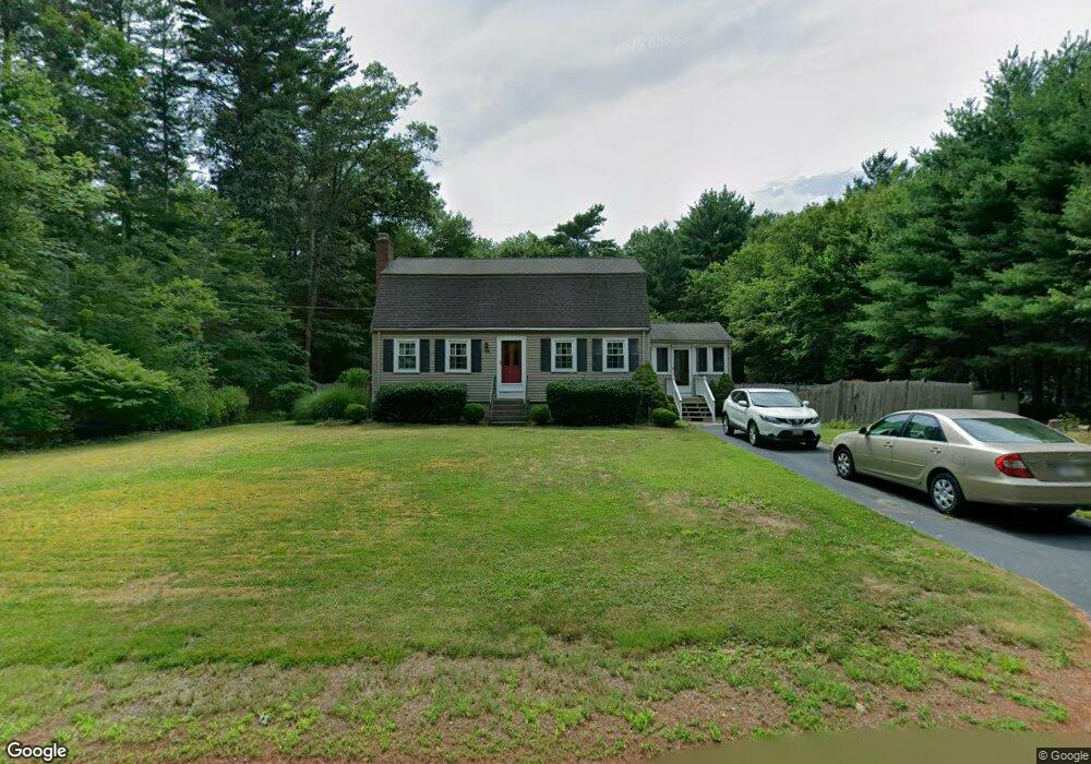
119 Old Pelham St Pembroke, MA 02359
Estimated Value: $614,022 - $687,000
3
Beds
2
Baths
1,550
Sq Ft
$420/Sq Ft
Est. Value
About This Home
This home is located at 119 Old Pelham St, Pembroke, MA 02359 and is currently estimated at $650,256, approximately $419 per square foot. 119 Old Pelham St is a home located in Plymouth County with nearby schools including Pembroke High School.
Ownership History
Date
Name
Owned For
Owner Type
Purchase Details
Closed on
Apr 17, 2015
Sold by
Stonkus Frances A and Stonkus Albert R
Bought by
Stonkus Albert R
Current Estimated Value
Purchase Details
Closed on
Sep 12, 2011
Sold by
Stonkus Albert R and Stonkus Frances A
Bought by
Stonkus Ft and Stonkus Albert R
Purchase Details
Closed on
Nov 4, 1968
Bought by
Stonkus Albert R
Create a Home Valuation Report for This Property
The Home Valuation Report is an in-depth analysis detailing your home's value as well as a comparison with similar homes in the area
Home Values in the Area
Average Home Value in this Area
Purchase History
| Date | Buyer | Sale Price | Title Company |
|---|---|---|---|
| Stonkus Albert R | -- | -- | |
| Stonkus Albert R | -- | -- | |
| Stonkus Ft | -- | -- | |
| Stonkus Albert R | $18,900 | -- |
Source: Public Records
Mortgage History
| Date | Status | Borrower | Loan Amount |
|---|---|---|---|
| Previous Owner | Stonkus Albert R | $73,000 | |
| Previous Owner | Stonkus Albert R | $67,300 | |
| Previous Owner | Stonkus Albert R | $75,000 |
Source: Public Records
Tax History Compared to Growth
Tax History
| Year | Tax Paid | Tax Assessment Tax Assessment Total Assessment is a certain percentage of the fair market value that is determined by local assessors to be the total taxable value of land and additions on the property. | Land | Improvement |
|---|---|---|---|---|
| 2025 | $6,123 | $509,400 | $280,100 | $229,300 |
| 2024 | $5,813 | $483,200 | $275,300 | $207,900 |
| 2023 | $6,010 | $472,500 | $275,300 | $197,200 |
| 2022 | $5,676 | $401,100 | $225,300 | $175,800 |
| 2021 | $5,460 | $374,500 | $214,900 | $159,600 |
| 2020 | $5,177 | $357,300 | $205,300 | $152,000 |
| 2019 | $5,069 | $347,200 | $200,100 | $147,100 |
| 2018 | $4,705 | $316,000 | $185,300 | $130,700 |
| 2017 | $4,642 | $307,400 | $175,300 | $132,100 |
| 2016 | $4,555 | $298,500 | $165,300 | $133,200 |
| 2015 | $4,195 | $284,600 | $150,100 | $134,500 |
Source: Public Records
Map
Nearby Homes
- 345 Forest St
- 61 Chapel St
- 16 Chapel St
- 202 Birch St
- 9 Montclair Ave
- 234 Forest St
- 27 Chestnut Rd
- 21 Prince Way
- 25 Little Brook Rd
- 32 Little Brook Rd
- 56 & 60 Prince Way
- 20 Edward Dr
- 600 Summer St Unit 6
- 298 Autumn Ave
- 0 Wildwood Cir
- 249 High St
- 57 Brandeis Cir
- 48 Grove St
- 6 Carriage Ln Unit 6
- 346 Summer St
- 111 Old Pelham St
- 117 Pelham St
- 125 Old Pelham St
- 107 Old Pelham St
- 105 Pelham St
- 131 Old Pelham St
- 136 Old Pelham St
- 0 Pelham St
- 110 Pelham St
- 100 Pelham St
- 99 Old Pelham St
- 141 Old Pelham St
- 90 Old Pelham St
- 91 Old Pelham St
- 106 Pelham St
- 145 Old Pelham St
- 87 Old Pelham St
- 147 Pelham St
- 149 Pelham St
- 15 Ironwood Rd