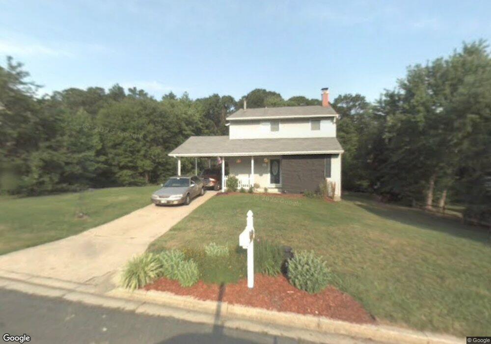
119 Otis Dr Severn, MD 21144
Estimated Value: $495,000 - $562,000
--
Bed
2
Baths
2,105
Sq Ft
$254/Sq Ft
Est. Value
About This Home
This home is located at 119 Otis Dr, Severn, MD 21144 and is currently estimated at $535,383, approximately $254 per square foot. 119 Otis Dr is a home located in Anne Arundel County with nearby schools including Severn Elementary School, Old Mill Middle School North, and Old Mill High School.
Ownership History
Date
Name
Owned For
Owner Type
Purchase Details
Closed on
Jun 21, 2006
Sold by
Kelley David L
Bought by
Morgan Dexter O'Neil and Morgan Patricia C
Current Estimated Value
Home Financials for this Owner
Home Financials are based on the most recent Mortgage that was taken out on this home.
Original Mortgage
$370,475
Outstanding Balance
$218,053
Interest Rate
6.59%
Mortgage Type
Purchase Money Mortgage
Estimated Equity
$317,330
Purchase Details
Closed on
Aug 31, 1987
Sold by
Thompson Thomas B
Bought by
Kelley David L
Home Financials for this Owner
Home Financials are based on the most recent Mortgage that was taken out on this home.
Original Mortgage
$96,950
Interest Rate
10.33%
Create a Home Valuation Report for This Property
The Home Valuation Report is an in-depth analysis detailing your home's value as well as a comparison with similar homes in the area
Home Values in the Area
Average Home Value in this Area
Purchase History
| Date | Buyer | Sale Price | Title Company |
|---|---|---|---|
| Morgan Dexter O'Neil | $365,000 | -- | |
| Kelley David L | $96,000 | -- |
Source: Public Records
Mortgage History
| Date | Status | Borrower | Loan Amount |
|---|---|---|---|
| Open | Morgan Dexter O'Neil | $370,475 | |
| Previous Owner | Kelley David L | $96,950 |
Source: Public Records
Tax History Compared to Growth
Tax History
| Year | Tax Paid | Tax Assessment Tax Assessment Total Assessment is a certain percentage of the fair market value that is determined by local assessors to be the total taxable value of land and additions on the property. | Land | Improvement |
|---|---|---|---|---|
| 2025 | $3,907 | $450,900 | $199,300 | $251,600 |
| 2024 | $3,907 | $430,067 | $0 | $0 |
| 2023 | $3,789 | $409,233 | $0 | $0 |
| 2022 | $3,532 | $388,400 | $171,300 | $217,100 |
| 2021 | $6,954 | $385,967 | $0 | $0 |
| 2020 | $3,383 | $383,533 | $0 | $0 |
| 2019 | $3,332 | $381,100 | $189,300 | $191,800 |
| 2018 | $3,625 | $357,533 | $0 | $0 |
| 2017 | $3,105 | $333,967 | $0 | $0 |
| 2016 | -- | $310,400 | $0 | $0 |
| 2015 | -- | $287,733 | $0 | $0 |
| 2014 | -- | $265,067 | $0 | $0 |
Source: Public Records
Map
Nearby Homes
- 207 Otis Dr
- 1010 Tuscany Ln
- 0 Musical Way
- 1012 Morgan Station Dr
- 7534 Honey Locust Ln
- 911 S Wieker Rd
- 900 S Wieker Rd
- 1434 Fairbanks Dr
- 7860 Telegraph Rd
- 7560 Old Telegraph Rd
- 771 Queenstown Rd
- 7406 Locust Dr
- 7945 Andorick Dr
- 7811 Wolf Run Ln
- 1454 Graham Farm Cir
- 203 Mill Crossing Ct
- 1143 Dorsey Rd
- 7875 Telegraph Rd
- 7633 Amos Ave
- 112 Farmbrook Ln