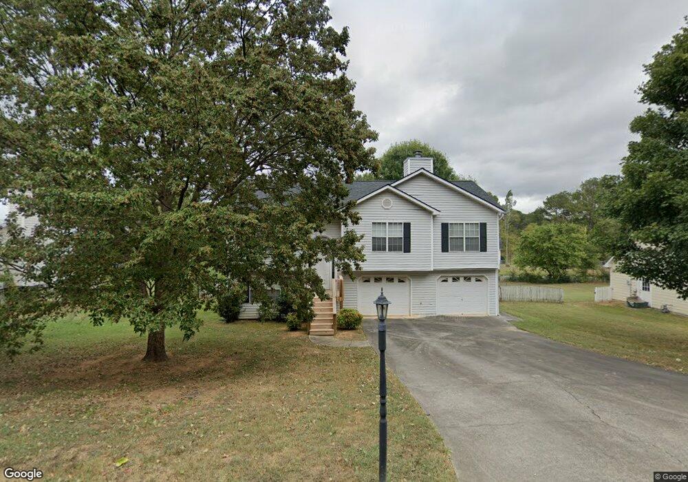
119 River Meadow Dr Calhoun, GA 30701
Estimated Value: $208,112 - $253,000
3
Beds
2
Baths
1,221
Sq Ft
$191/Sq Ft
Est. Value
About This Home
This home is located at 119 River Meadow Dr, Calhoun, GA 30701 and is currently estimated at $233,028, approximately $190 per square foot. 119 River Meadow Dr is a home located in Gordon County with nearby schools including Calhoun Primary School, Calhoun Elementary School, and Calhoun Middle School.
Ownership History
Date
Name
Owned For
Owner Type
Purchase Details
Closed on
Dec 28, 2001
Sold by
Brent Stepp Construction
Bought by
Boswell Stephen Barry
Current Estimated Value
Purchase Details
Closed on
Oct 5, 2001
Sold by
Mcreynolds Jeffrey D
Bought by
Brent Stepp Construction
Purchase Details
Closed on
Nov 14, 1997
Bought by
Mcreynolds Jeffrey D
Purchase Details
Closed on
Jun 30, 1997
Bought by
Lusian Gerald Inc
Create a Home Valuation Report for This Property
The Home Valuation Report is an in-depth analysis detailing your home's value as well as a comparison with similar homes in the area
Home Values in the Area
Average Home Value in this Area
Purchase History
| Date | Buyer | Sale Price | Title Company |
|---|---|---|---|
| Boswell Stephen Barry | $94,700 | -- | |
| Brent Stepp Construction | $86,000 | -- | |
| Mcreynolds Jeffrey D | $84,900 | -- | |
| Lusian Gerald Inc | $14,000 | -- |
Source: Public Records
Tax History Compared to Growth
Tax History
| Year | Tax Paid | Tax Assessment Tax Assessment Total Assessment is a certain percentage of the fair market value that is determined by local assessors to be the total taxable value of land and additions on the property. | Land | Improvement |
|---|---|---|---|---|
| 2024 | $1,808 | $64,960 | $4,080 | $60,880 |
| 2023 | $1,703 | $61,200 | $4,080 | $57,120 |
| 2022 | $503 | $54,880 | $3,920 | $50,960 |
| 2021 | $1,339 | $45,600 | $3,920 | $41,680 |
| 2020 | $1,366 | $46,160 | $3,920 | $42,240 |
| 2019 | $1,364 | $46,160 | $3,920 | $42,240 |
| 2018 | $399 | $43,400 | $3,920 | $39,480 |
| 2017 | $387 | $41,360 | $3,920 | $37,440 |
| 2016 | $388 | $41,360 | $3,920 | $37,440 |
| 2015 | $386 | $40,720 | $3,920 | $36,800 |
| 2014 | $368 | $39,348 | $3,920 | $35,428 |
Source: Public Records
Map
Nearby Homes
- Spruce Plan at Riverside at Calhoun
- Cedar Plan at Riverside at Calhoun
- Birch Plan at Riverside at Calhoun
- Hazel Plan at Riverside at Calhoun
- Elder Plan at Riverside at Calhoun
- 516 Mcginnis Cir
- 156 Cooper Ln
- 00 Mauldin Rd NW
- 000 Mauldin Rd
- 104 Cornwell Way
- 208 Mcginnis Cir
- 803 Riverside Dr
- 742 Riverside Dr
- 103 Mcginnis Cir
- 0 Red Bud Rd NE Unit 123029
- 145 Green Row
- 106 Windmill Ct
- 104 Windmill Ct
- 113 Waterside Dr
- 113 Mill Pond Ln
- 115 River Meadow Dr
- 123 River Meadow Dr
- 111 River Meadow Dr
- 127 River Meadow Dr
- 104 Rolling River Dr
- 21 Colton Dr
- 9 Colton Dr
- 5 Colton Dr
- 13 Colton Dr
- 13 Colton Dr Unit 13
- 11 Colton Dr
- 11 Colton Dr Unit 11
- 7 Colton Dr
- 101 Colton Dr
- 101 Colton Dr Unit 21
- 103 Overlook Dr NW
- 856 Henderson Bend Rd NW
- 107 River Meadow Dr
- 103 Colton Dr
- 107 Rolling River Dr