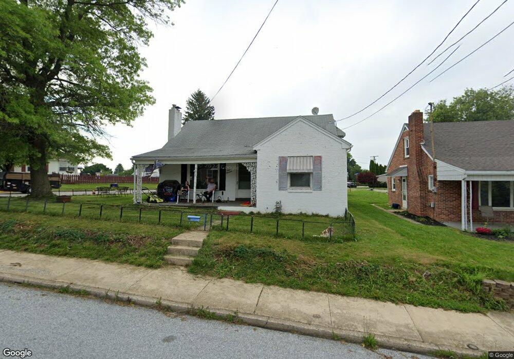
119 W Maple St Dallastown, PA 17313
Estimated Value: $218,000 - $254,000
2
Beds
1
Bath
1,602
Sq Ft
$145/Sq Ft
Est. Value
About This Home
This home is located at 119 W Maple St, Dallastown, PA 17313 and is currently estimated at $232,065, approximately $144 per square foot. 119 W Maple St is a home located in York County with nearby schools including Dallastown Elementary School, Dallastown Area Middle School, and Dallastown Area High School.
Ownership History
Date
Name
Owned For
Owner Type
Purchase Details
Closed on
Dec 31, 2003
Sold by
Krug Charlotte M
Bought by
Smith Lyle U and Herishen Smith Stacey A
Current Estimated Value
Home Financials for this Owner
Home Financials are based on the most recent Mortgage that was taken out on this home.
Original Mortgage
$79,200
Outstanding Balance
$36,936
Interest Rate
5.86%
Mortgage Type
Purchase Money Mortgage
Estimated Equity
$195,129
Create a Home Valuation Report for This Property
The Home Valuation Report is an in-depth analysis detailing your home's value as well as a comparison with similar homes in the area
Home Values in the Area
Average Home Value in this Area
Purchase History
| Date | Buyer | Sale Price | Title Company |
|---|---|---|---|
| Smith Lyle U | $99,000 | -- |
Source: Public Records
Mortgage History
| Date | Status | Borrower | Loan Amount |
|---|---|---|---|
| Open | Smith Lyle U | $79,200 |
Source: Public Records
Tax History Compared to Growth
Tax History
| Year | Tax Paid | Tax Assessment Tax Assessment Total Assessment is a certain percentage of the fair market value that is determined by local assessors to be the total taxable value of land and additions on the property. | Land | Improvement |
|---|---|---|---|---|
| 2025 | $3,832 | $110,330 | $21,320 | $89,010 |
| 2024 | $3,832 | $110,330 | $21,320 | $89,010 |
| 2023 | $3,832 | $110,330 | $21,320 | $89,010 |
| 2022 | $3,710 | $110,330 | $21,320 | $89,010 |
| 2021 | $3,499 | $110,330 | $21,320 | $89,010 |
| 2020 | $3,499 | $110,330 | $21,320 | $89,010 |
| 2019 | $3,488 | $110,330 | $21,320 | $89,010 |
| 2018 | $3,488 | $110,330 | $21,320 | $89,010 |
| 2017 | $3,352 | $110,330 | $21,320 | $89,010 |
| 2016 | $0 | $110,330 | $21,320 | $89,010 |
| 2015 | -- | $110,330 | $21,320 | $89,010 |
| 2014 | -- | $110,330 | $21,320 | $89,010 |
Source: Public Records
Map
Nearby Homes
- 263 W Main St
- 53 S Franklin St
- 18 E Howard St
- 79 S Franklin St
- 2981 Sunset Dr
- 197 S Main St
- 74 S Main St
- 430 E Maple St
- 117 S Park St
- 141 W Water St
- 0 Lot 15 Gary Dr
- 1 N Duke St
- 705 Summit Dr
- 114 Heather Glen Dr
- 227 Jutland Way
- 2960 Starfire Dr
- 630 Woodland Ave
- 680 Hampstead Ct
- 55 Belmar Dr
- 350 Avon Dr Unit 270
- 115 W Maple St
- 207 W Maple St
- 109 W Maple St Unit 140
- 109 W Maple St
- 107 W Maple St
- 108 W Maple St
- 128 W Maple St
- 213 W Maple St
- 103 W Maple St
- 104 W Maple St
- 215 W Maple St
- 100 W Maple St
- 202 W Broad St
- 75 W Maple St
- 161 N School Place
- 219 W Maple St
- 69 W Maple St Unit 144
- 214 W Maple St
- 214 W Broad St
- 72 W Maple St