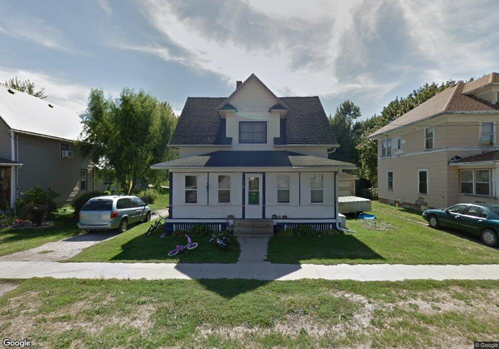
119 W Pershing Dr Brooklyn, IA 52211
Estimated Value: $114,241 - $167,000
3
Beds
1
Bath
1,562
Sq Ft
$93/Sq Ft
Est. Value
About This Home
This home is located at 119 W Pershing Dr, Brooklyn, IA 52211 and is currently estimated at $145,560, approximately $93 per square foot. 119 W Pershing Dr is a home located in Poweshiek County with nearby schools including Brooklyn-Guernsey-Malcom Elementary School and Brooklyn-Guernsey-Malcom Junior/Senior High School.
Ownership History
Date
Name
Owned For
Owner Type
Purchase Details
Closed on
Mar 24, 2021
Sold by
Cunningham Dylan
Bought by
Mann Nicole and Wonick William
Current Estimated Value
Purchase Details
Closed on
Jun 26, 2019
Sold by
Mann Nicole
Bought by
Mann Nicole and Cunnigham Dylan
Purchase Details
Closed on
Jun 5, 2009
Sold by
Hawkins Mark Eugene and Hawkins Sally J
Bought by
Mann Nicole
Create a Home Valuation Report for This Property
The Home Valuation Report is an in-depth analysis detailing your home's value as well as a comparison with similar homes in the area
Home Values in the Area
Average Home Value in this Area
Purchase History
| Date | Buyer | Sale Price | Title Company |
|---|---|---|---|
| Mann Nicole | -- | None Available | |
| Mann Nicole | -- | None Available | |
| Mann Nicole | -- | -- | |
| Mann Nicole | $25,000 | None Available |
Source: Public Records
Mortgage History
| Date | Status | Borrower | Loan Amount |
|---|---|---|---|
| Closed | Mann Nicole | $0 |
Source: Public Records
Tax History Compared to Growth
Tax History
| Year | Tax Paid | Tax Assessment Tax Assessment Total Assessment is a certain percentage of the fair market value that is determined by local assessors to be the total taxable value of land and additions on the property. | Land | Improvement |
|---|---|---|---|---|
| 2025 | $1,072 | $85,540 | $11,810 | $73,730 |
| 2024 | $1,354 | $75,850 | $10,500 | $65,350 |
| 2023 | $980 | $75,850 | $10,500 | $65,350 |
| 2022 | $932 | $59,530 | $8,350 | $51,180 |
| 2021 | $932 | $56,160 | $7,880 | $48,280 |
| 2020 | $728 | $56,160 | $7,880 | $48,280 |
| 2019 | $784 | $46,780 | $7,880 | $38,900 |
| 2018 | $800 | $46,780 | $7,880 | $38,900 |
| 2017 | $826 | $46,780 | $7,880 | $38,900 |
| 2016 | $772 | $46,780 | $7,880 | $38,900 |
| 2015 | $772 | $46,780 | $7,880 | $38,900 |
| 2014 | $752 | $46,780 | $7,880 | $38,900 |
Source: Public Records
Map
Nearby Homes
- 410 Sunset Dr
- 407 Sunset Dr
- 000 Monroe St
- 511 N Orchard St
- 616 Broadway St
- 715 Broadway St
- 524 W Pershing Dr
- 610 E Pershing Dr
- 617 E Des Moines St
- 711 E Des Moines St
- 107 Brady St
- 4269 175th St
- 2057 Larrys Dr
- 3125 Holiday Ln
- 1410 E Ridge Dr
- 1353 Wilson Ave
- 1261 Holiday Ln
- 2160 S Lake Shore Dr
- 3085 E Lakeshore Dr
- 1332 Holiday Ln
- 115 W Pershing Dr
- 123 W Pershing Dr
- 425 Sunset Dr
- 111 W Pershing Dr
- 203 W Pershing Dr
- 426 Sunset Dr
- 422 Sunset Dr
- 107 W Pershing Dr
- 421 Sunset Dr
- 209 W Pershing Dr
- 124 W Pershing Dr
- 118 W Pershing Dr
- 114 W Pershing Dr
- 110 W Pershing Dr
- 507 Adams St
- 208 W Pershing Dr
- 418 Sunset Dr
- 510 Jackson St
- 419 Sunset Dr
- 204 W Pershing Dr