
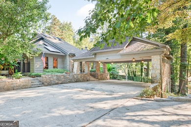
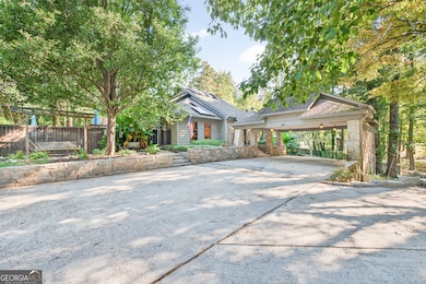
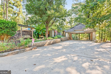
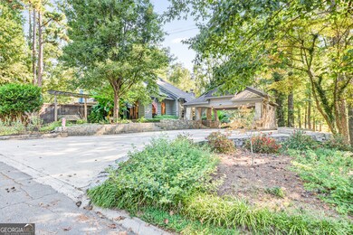
1190 Brookside Dr NE Conyers, GA 30012
Estimated payment $2,503/month
Highlights
- Home Theater
- Solar Power System
- Contemporary Architecture
- Above Ground Pool
- Deck
- Family Room with Fireplace
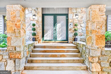
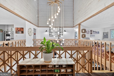
About This Home
Full of Character and Mid-Century Personality, this Architectural Contemporary 4 Bedroom, 3 Bath Home Sits Proudly on a Large Corner Lot Just Minutes From Olde Town Conyers. The Home's Design Features Vaulted Ceilings, Skylights, and Unique Light-Filled Spaces that Give It an Open, Airy Feel. From the Moment You Enter the Foyer, the Layout Invites You In With a Kitchen to the Left and Living Room to the Right Connected by Walkways With Open Views to the Space Below. The Main Level Features 2 Bedrooms and 2 Full Baths, Including an Owner's Suite With a Private Sitting Area or Office Space. The Living Room and Family Room on the Lower Level Both Offer Dual Fireplaces, Providing Warmth and Charm Upstairs and Down. Hardwood Floors Run Through the Main Level, While the Granite Kitchen Countertops and Architectural Details Bring Just the Right Blend of Modern Touches. Downstairs, the Finished Basement Offers 2 Additional Bedrooms, a Full Bath, an Extra Living Space With Fireplace, an Office or Playroom, and Unfinished Storage. This Home Also Includes a Solar Panel System, Offering Energy Efficiency and Long-Term Savings. Outside, Enjoy a Huge Fenced Backyard, an Above Ground Pool, and a Pass-Through Carport That Connects Two Streets With Driveway Access on Both Sides of the Corner Lot. This Is Not Your Typical Layout, and That's Exactly What Makes It Special. It's a Home That Stands Out With Thoughtful Design, Artistic Angles, and Room To Make It Your Own.
Home Details
Home Type
- Single Family
Est. Annual Taxes
- $7,904
Year Built
- Built in 1976
Lot Details
- 0.69 Acre Lot
- Privacy Fence
- Back Yard Fenced
- Corner Lot
- Partially Wooded Lot
- Grass Covered Lot
Home Design
- Contemporary Architecture
- 2-Story Property
- Composition Roof
- Wood Siding
Interior Spaces
- Beamed Ceilings
- Vaulted Ceiling
- Ceiling Fan
- Skylights
- Gas Log Fireplace
- Fireplace Features Masonry
- Entrance Foyer
- Family Room with Fireplace
- 2 Fireplaces
- Great Room
- Living Room with Fireplace
- Home Theater
- Home Office
- Bonus Room
- Home Gym
Kitchen
- Breakfast Area or Nook
- Built-In Oven
- Cooktop
- Dishwasher
- Stainless Steel Appliances
- Solid Surface Countertops
Flooring
- Wood
- Carpet
- Tile
Bedrooms and Bathrooms
- 4 Bedrooms | 2 Main Level Bedrooms
- Primary Bedroom on Main
- Split Bedroom Floorplan
- Walk-In Closet
- Double Vanity
Laundry
- Laundry Room
- Dryer
- Washer
Finished Basement
- Basement Fills Entire Space Under The House
- Interior and Exterior Basement Entry
- Fireplace in Basement
- Finished Basement Bathroom
- Laundry in Basement
- Natural lighting in basement
Parking
- Carport
- Side or Rear Entrance to Parking
Eco-Friendly Details
- Solar Power System
Outdoor Features
- Above Ground Pool
- Deck
Schools
- Hicks Elementary School
- Conyers Middle School
- Rockdale County High School
Utilities
- Forced Air Heating and Cooling System
- Common Heating System
- Heating System Uses Natural Gas
- 220 Volts
- Gas Water Heater
- High Speed Internet
- Phone Available
- Cable TV Available
Community Details
- No Home Owners Association
- Valley View Estates Subdivision
Map
Home Values in the Area
Average Home Value in this Area
Tax History
| Year | Tax Paid | Tax Assessment Tax Assessment Total Assessment is a certain percentage of the fair market value that is determined by local assessors to be the total taxable value of land and additions on the property. | Land | Improvement |
|---|---|---|---|---|
| 2024 | $5,931 | $152,280 | $24,000 | $128,280 |
| 2023 | $3,991 | $105,760 | $20,200 | $85,560 |
| 2022 | $3,797 | $100,160 | $20,200 | $79,960 |
| 2021 | $4,021 | $100,160 | $20,200 | $79,960 |
| 2020 | $2,917 | $71,240 | $8,120 | $63,120 |
| 2019 | $2,974 | $71,240 | $8,120 | $63,120 |
| 2018 | $1,741 | $71,240 | $8,120 | $63,120 |
| 2017 | $4,126 | $62,960 | $8,120 | $54,840 |
| 2016 | $3,933 | $59,400 | $8,120 | $51,280 |
| 2015 | $1,254 | $58,200 | $8,120 | $50,080 |
| 2014 | $1,121 | $58,200 | $8,120 | $50,080 |
| 2013 | -- | $67,000 | $15,400 | $51,600 |
Property History
| Date | Event | Price | List to Sale | Price per Sq Ft |
|---|---|---|---|---|
| 10/15/2025 10/15/25 | Pending | -- | -- | -- |
| 10/08/2025 10/08/25 | For Sale | $349,900 | 0.0% | $95 / Sq Ft |
| 09/26/2025 09/26/25 | Pending | -- | -- | -- |
| 09/23/2025 09/23/25 | For Sale | $349,900 | -- | $95 / Sq Ft |
Purchase History
| Date | Type | Sale Price | Title Company |
|---|---|---|---|
| Warranty Deed | $187,500 | -- | |
| Deed | $168,300 | -- |
Mortgage History
| Date | Status | Loan Amount | Loan Type |
|---|---|---|---|
| Open | $184,103 | FHA | |
| Previous Owner | $188,787 | FHA |
Source: Georgia MLS
MLS Number: 10611304
APN: C32-0-01-0051
Disclaimer: Certain information contained herein is derived from information provided by parties other than Homes.com. All information provided is deemed reliable, but is not guaranteed to be accurate and should be independently verified.
![]() The data relating to real estate for sale on this web site comes in part from the Broker Reciprocity Program of Georgia MLS. Real estate listings held by brokerage firms other than Redfin are marked with the Broker Reciprocity logo and detailed information about them includes the name of the listing brokers. Information deemed reliable but not guaranteed. Copyright 2025 Georgia MLS. All rights reserved.
The data relating to real estate for sale on this web site comes in part from the Broker Reciprocity Program of Georgia MLS. Real estate listings held by brokerage firms other than Redfin are marked with the Broker Reciprocity logo and detailed information about them includes the name of the listing brokers. Information deemed reliable but not guaranteed. Copyright 2025 Georgia MLS. All rights reserved.
- 1210 Brookside Dr NE
- 1186 Eastview Rd NE
- 1312 Milstead Ave NE
- 1268 Woodland Rd NE
- 121 Wellbrook Ct NE Unit 11
- 126 Wellbrook Ct NE Unit 44
- 1080 Eastview Rd NE
- 584 Oak Ct NW
- 1064 Eastview Rd NE
- 1098 Eastview Cir NE
- 1271 Eastview Rd NE
- 00 Hicks Cir N
- 1128 Milstead Ave NE
- 1255 Norton Rd NE
- 1065 Milstead Ave NE
