Estimated Value: $220,341 - $228,000
4
Beds
3
Baths
2,085
Sq Ft
$108/Sq Ft
Est. Value
About This Home
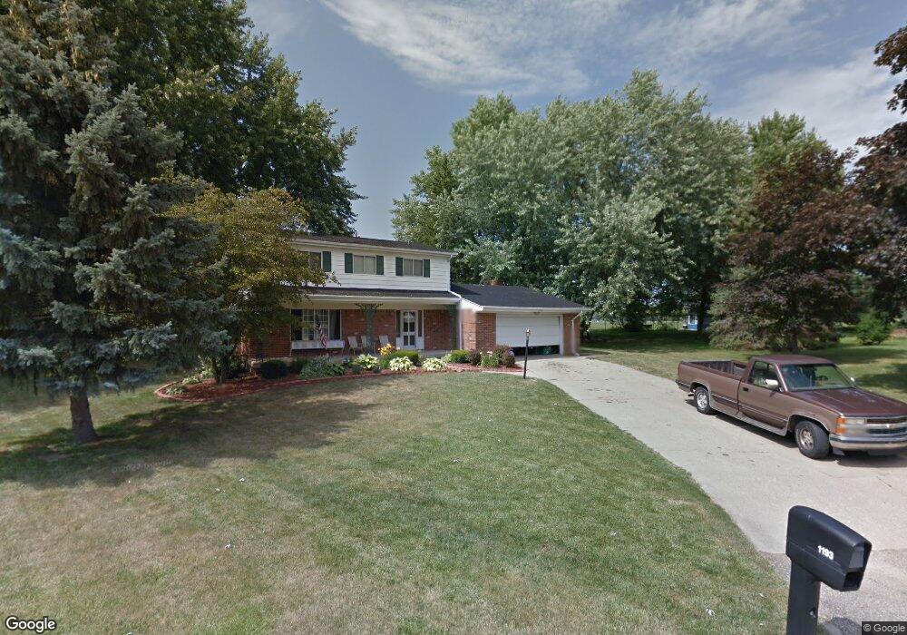
This home is located at 1193 Cabot Dr, Flint, MI 48532 and is currently estimated at $224,835, approximately $107 per square foot. 1193 Cabot Dr is a home located in Genesee County with nearby schools including Carman-Ainsworth High School, Genesee STEM Academy, and Linden Charter Academy.
Ownership History
Date
Name
Owned For
Owner Type
Purchase Details
Closed on
Jun 2, 2008
Sold by
Taylor Miriam Annette and Mysliwski Miriam A
Bought by
Lenton Lashawn
Current Estimated Value
Home Financials for this Owner
Home Financials are based on the most recent Mortgage that was taken out on this home.
Original Mortgage
$126,500
Outstanding Balance
$80,655
Interest Rate
6.01%
Mortgage Type
FHA
Estimated Equity
$144,180
Purchase Details
Closed on
May 8, 2007
Sold by
Mysllwski Robert
Bought by
Taylor Miriam Annette
Purchase Details
Closed on
Feb 19, 2001
Sold by
Fugenschuh William J and Fugenschuh Florence J
Bought by
Mysliwski Robert and Taylor Mysliwski Miriam
Create a Home Valuation Report for This Property
The Home Valuation Report is an in-depth analysis detailing your home's value as well as a comparison with similar homes in the area
Home Values in the Area
Average Home Value in this Area
Purchase History
| Date | Buyer | Sale Price | Title Company |
|---|---|---|---|
| Lenton Lashawn | $127,500 | Cislo Title Co | |
| Taylor Miriam Annette | -- | None Available | |
| Mysliwski Robert | $130,000 | Sargents Title Company |
Source: Public Records
Mortgage History
| Date | Status | Borrower | Loan Amount |
|---|---|---|---|
| Open | Lenton Lashawn | $126,500 |
Source: Public Records
Tax History
| Year | Tax Paid | Tax Assessment Tax Assessment Total Assessment is a certain percentage of the fair market value that is determined by local assessors to be the total taxable value of land and additions on the property. | Land | Improvement |
|---|---|---|---|---|
| 2025 | $2,588 | $101,100 | $0 | $0 |
| 2024 | $1,336 | $98,000 | $0 | $0 |
| 2023 | $1,275 | $91,200 | $0 | $0 |
| 2022 | $1,125 | $83,700 | $0 | $0 |
| 2021 | $2,288 | $77,700 | $0 | $0 |
| 2020 | $1,145 | $65,100 | $0 | $0 |
| 2019 | $1,129 | $60,700 | $0 | $0 |
| 2018 | $2,134 | $59,600 | $0 | $0 |
| 2017 | $2,155 | $59,600 | $0 | $0 |
| 2016 | $2,115 | $51,900 | $0 | $0 |
| 2015 | $1,896 | $49,500 | $0 | $0 |
| 2014 | $1,125 | $47,500 | $0 | $0 |
| 2012 | -- | $47,800 | $47,800 | $0 |
Source: Public Records
Map
Nearby Homes
- 1090 Cabot Dr
- 5021 Forest Side Dr
- 1246 Dyemeadow Ln
- 1368 Autumn Dr
- 1095 Devenish Ln
- 1034 Normandy Terrace Dr
- 000 Devenish Ln
- 2008 Beekman Ct
- 2 Charter Dr
- 2174 Mill Rd
- 1161 S Dye Rd
- 4075 Townview Dr
- 0 Charter Dr Unit 50153638
- Graham Rd N Graham Rd
- 4022 Beecher Rd
- 1137 S Graham Rd
- 5477 Fernwood Dr
- 3.9 Acres W Court St
- 5551 Sugar Bush Ln
- 4199 Sheraton Dr
Your Personal Tour Guide
Ask me questions while you tour the home.