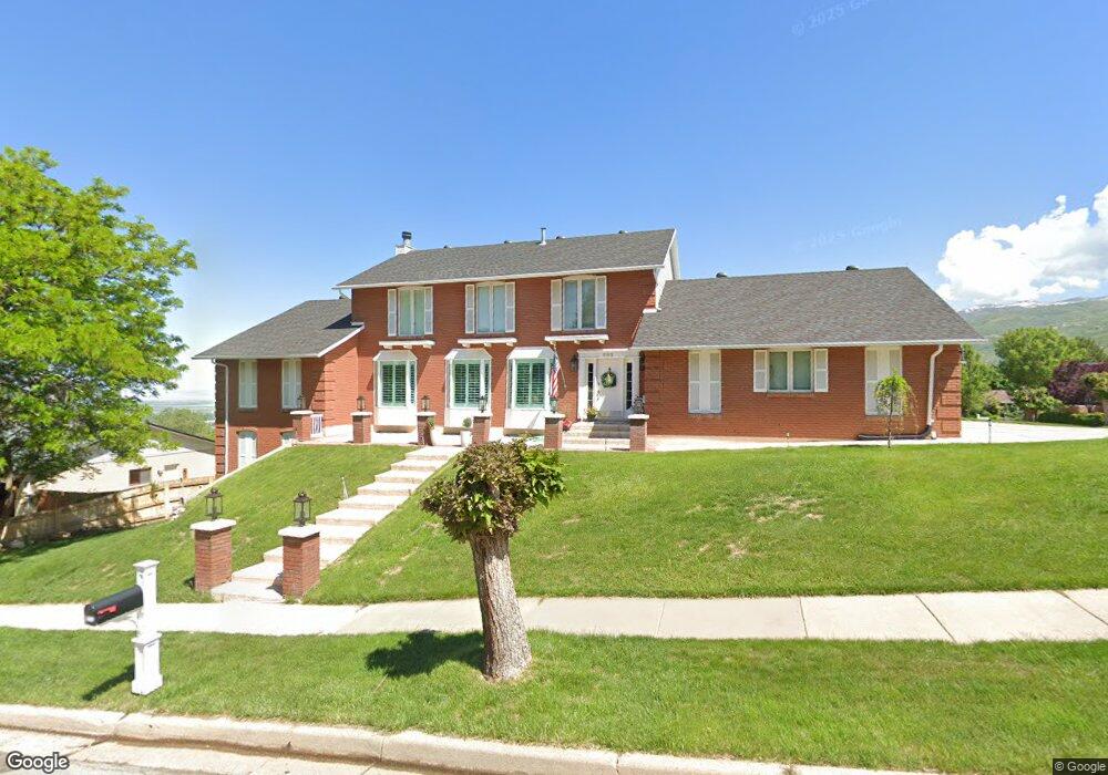
1193 E 2050 S Bountiful, UT 84010
Estimated Value: $902,000 - $1,152,000
5
Beds
4
Baths
5,136
Sq Ft
$192/Sq Ft
Est. Value
About This Home
This home is located at 1193 E 2050 S, Bountiful, UT 84010 and is currently estimated at $988,320, approximately $192 per square foot. 1193 E 2050 S is a home located in Davis County with nearby schools including Muir School, Mueller Park Junior High School, and Bountiful High School.
Ownership History
Date
Name
Owned For
Owner Type
Purchase Details
Closed on
Jun 11, 2014
Sold by
Kilpatrick Paul G and Kilpatrick Geraldine P
Bought by
Malmrose Jesse Scott and Malmrose Lori R
Current Estimated Value
Purchase Details
Closed on
Oct 4, 2012
Sold by
Kilpatrick Paul G and Kilpatrick Geraldine P
Bought by
Kilpatrick Paul G and Kilpatrick Geraldine P
Create a Home Valuation Report for This Property
The Home Valuation Report is an in-depth analysis detailing your home's value as well as a comparison with similar homes in the area
Purchase History
| Date | Buyer | Sale Price | Title Company |
|---|---|---|---|
| Malmrose Jesse Scott | -- | First American Title Co Llc | |
| Kilpatrick Paul G | -- | None Available |
Source: Public Records
Tax History
| Year | Tax Paid | Tax Assessment Tax Assessment Total Assessment is a certain percentage of the fair market value that is determined by local assessors to be the total taxable value of land and additions on the property. | Land | Improvement |
|---|---|---|---|---|
| 2025 | $5,466 | $510,950 | $139,900 | $371,050 |
| 2024 | $5,030 | $482,901 | $128,783 | $354,118 |
| 2023 | $4,916 | $856,000 | $236,208 | $619,792 |
| 2022 | $4,851 | $462,550 | $126,158 | $336,392 |
| 2021 | $4,271 | $623,000 | $187,739 | $435,261 |
| 2020 | $3,773 | $553,000 | $170,886 | $382,114 |
| 2019 | $3,866 | $554,000 | $162,372 | $391,628 |
| 2018 | $3,674 | $519,000 | $151,632 | $367,368 |
| 2016 | $2,898 | $220,605 | $50,856 | $169,749 |
| 2015 | $2,976 | $214,500 | $50,856 | $163,644 |
| 2014 | $3,332 | $248,333 | $51,252 | $197,081 |
| 2013 | -- | $184,481 | $61,366 | $123,115 |
Source: Public Records
Map
Nearby Homes
- 1888 S 1150 E
- 2156 Elaine Dr
- 2115 S Ridgewood Way
- 994 Deborah Dr
- 1785 1450 E
- 2136 S 900 E
- 1812 S 900 E
- 0 Bountiful Blvd
- 831 E San Simeon Way S
- 1735 S Temple Ct Unit 203
- 1596 E Millbrook Way
- 761 San Simeon Way
- 1761 S Davis Blvd
- 2768 S 1500 E
- 775 E 1500 S
- 631 E 1700 S
- 1885 Spring Creek Dr
- 795 Abby Ln Unit 5
- 1742 E Ridge Point Dr
- 1886 S Jeri Dr
- 2008 Browns Park Dr
- 1187 E 2050 S
- 2011 S 1175 E
- 2063 Browns Park Dr
- 2045 Browns Park Dr
- 2062 S 1200 E
- 2007 Browns Park Dr
- 2062 Browns Park Dr
- 1988 Browns Park Dr
- 1216 E 2050 S
- 1997 S 1175 E
- 1181 E 2050 S
- 1207 Golf Course Cir
- 1164 Deborah Dr
- 1987 Browns Park Dr
- 2021 S 1175 E
- 1207 Golf Course Dr
- 1235 E 2050 S
- 1164 E 2050 S
- 1236 E 2050 S
Your Personal Tour Guide
Ask me questions while you tour the home.