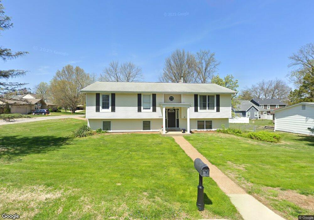
11933 Grant Place Saint Louis, MO 63131
Estimated Value: $479,000 - $641,000
3
Beds
2
Baths
2,042
Sq Ft
$261/Sq Ft
Est. Value
About This Home
This home is located at 11933 Grant Place, Saint Louis, MO 63131 and is currently estimated at $532,484, approximately $260 per square foot. 11933 Grant Place is a home located in St. Louis County with nearby schools including Westchester Elementary School, North Kirkwood Middle School, and Kirkwood Senior High School.
Ownership History
Date
Name
Owned For
Owner Type
Purchase Details
Closed on
Dec 19, 2003
Sold by
Ludwick R David and Ludwick Rebecca O
Bought by
Zuniga Lance W and Zuniga Casey R
Current Estimated Value
Home Financials for this Owner
Home Financials are based on the most recent Mortgage that was taken out on this home.
Original Mortgage
$142,400
Outstanding Balance
$65,893
Interest Rate
5.86%
Mortgage Type
Purchase Money Mortgage
Estimated Equity
$466,591
Create a Home Valuation Report for This Property
The Home Valuation Report is an in-depth analysis detailing your home's value as well as a comparison with similar homes in the area
Home Values in the Area
Average Home Value in this Area
Purchase History
| Date | Buyer | Sale Price | Title Company |
|---|---|---|---|
| Zuniga Lance W | $178,000 | -- |
Source: Public Records
Mortgage History
| Date | Status | Borrower | Loan Amount |
|---|---|---|---|
| Open | Zuniga Lance W | $142,400 | |
| Closed | Zuniga Lance W | $17,800 |
Source: Public Records
Tax History Compared to Growth
Tax History
| Year | Tax Paid | Tax Assessment Tax Assessment Total Assessment is a certain percentage of the fair market value that is determined by local assessors to be the total taxable value of land and additions on the property. | Land | Improvement |
|---|---|---|---|---|
| 2025 | $4,436 | $87,970 | $57,300 | $30,670 |
| 2024 | $4,436 | $76,550 | $42,980 | $33,570 |
| 2023 | $4,368 | $76,550 | $42,980 | $33,570 |
| 2022 | $4,167 | $68,060 | $42,980 | $25,080 |
| 2021 | $4,122 | $68,060 | $42,980 | $25,080 |
| 2020 | $3,790 | $60,120 | $42,830 | $17,290 |
| 2019 | $3,795 | $60,120 | $42,830 | $17,290 |
| 2018 | $3,566 | $50,680 | $26,660 | $24,020 |
| 2017 | $3,576 | $50,680 | $26,660 | $24,020 |
| 2016 | $2,615 | $37,430 | $19,040 | $18,390 |
| 2015 | $2,618 | $37,430 | $19,040 | $18,390 |
| 2014 | $2,353 | $32,840 | $9,960 | $22,880 |
Source: Public Records
Map
Nearby Homes
- 11909 Lillian Ave
- 11913 Lillian Ave
- 12006 Montour Dr
- 919 Nana Ln
- 896 Twin Pine Dr
- 1029 Kinstern Dr
- 1090 Kinstern Dr
- 1710 Lynkirk Ln
- 1126 Bopp Rd
- 1001 Dovergate Dr
- 12224 TBB Roger Ln
- 946 Rochdale Dr
- 918 N Ballas Rd
- 1312 W Essex Ave
- 811 Cherry St
- 2000 Trailcrest Ln Unit 3
- 11358 Manchester Rd
- 2037 Trailcrest Ln Unit 7
- 2005 Woodland Knoll
- 512 Bryan Ave
- 11927 Grant Place
- 11948 Amherst Dr
- 848 Windemere Ave
- 11944 Amherst Dr
- 855 Windemere Ave
- 11919 Grant Place
- 11936 Amherst Dr
- 11920 Grant Place
- 11940 Amherst Dr
- 808 Windemere Ave
- 975 Windemere Ave
- 844 Windemere Ave
- 845 Windemere Ave
- 11914 Grant Place
- 11911 Grant Place
- 11905 Grant Place
- 841 Windemere Ave
- 11949 Grant Place
- 11928 Amherst Dr
- 974 Lindemann Rd