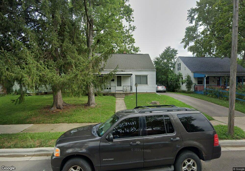
1194 Delno Ave Columbus, OH 43224
North Linden NeighborhoodEstimated Value: $142,000 - $217,000
3
Beds
1
Bath
1,080
Sq Ft
$166/Sq Ft
Est. Value
About This Home
This home is located at 1194 Delno Ave, Columbus, OH 43224 and is currently estimated at $179,110, approximately $165 per square foot. 1194 Delno Ave is a home located in Franklin County with nearby schools including Como Elementary School, Dominion Middle School, and Whetstone High School.
Ownership History
Date
Name
Owned For
Owner Type
Purchase Details
Closed on
Nov 17, 1999
Sold by
Hud
Bought by
Maurer James E
Current Estimated Value
Purchase Details
Closed on
Feb 16, 1999
Sold by
Pace Arthur J and Bank One Na
Bought by
Hud
Purchase Details
Closed on
Mar 18, 1987
Bought by
Pace Arthur J and Pace Gloria E
Purchase Details
Closed on
Aug 1, 1986
Purchase Details
Closed on
Aug 1, 1985
Create a Home Valuation Report for This Property
The Home Valuation Report is an in-depth analysis detailing your home's value as well as a comparison with similar homes in the area
Home Values in the Area
Average Home Value in this Area
Purchase History
| Date | Buyer | Sale Price | Title Company |
|---|---|---|---|
| Maurer James E | -- | Contract Processing & Title | |
| Hud | $50,000 | -- | |
| Pace Arthur J | $49,900 | -- | |
| -- | -- | -- | |
| -- | -- | -- |
Source: Public Records
Tax History Compared to Growth
Tax History
| Year | Tax Paid | Tax Assessment Tax Assessment Total Assessment is a certain percentage of the fair market value that is determined by local assessors to be the total taxable value of land and additions on the property. | Land | Improvement |
|---|---|---|---|---|
| 2024 | $2,279 | $49,740 | $11,900 | $37,840 |
| 2023 | $2,251 | $49,735 | $11,900 | $37,835 |
| 2022 | $1,483 | $27,900 | $6,300 | $21,600 |
| 2021 | $1,485 | $27,900 | $6,300 | $21,600 |
| 2020 | $1,488 | $27,900 | $6,300 | $21,600 |
| 2019 | $1,417 | $22,790 | $5,250 | $17,540 |
| 2018 | $1,330 | $22,790 | $5,250 | $17,540 |
| 2017 | $1,417 | $22,790 | $5,250 | $17,540 |
| 2016 | $1,368 | $20,130 | $3,920 | $16,210 |
| 2015 | $1,245 | $20,130 | $3,920 | $16,210 |
| 2014 | $1,248 | $20,130 | $3,920 | $16,210 |
| 2013 | $616 | $20,125 | $3,920 | $16,205 |
Source: Public Records
Map
Nearby Homes
- 1225 Sandlin Ave
- 1247 Weldon Ave
- 2913 Gerbert Rd
- 2981 Gerbert Rd
- 2950 Grasmere Ave
- 3043 McGuffey Rd
- 3071 Karl Rd
- 2905 Ontario St
- 2860 Grasmere Ave
- 2888 Howey Rd
- 3107 Hamilton Ave
- 2899 Howey Rd
- 3129 McGuffey Rd
- 2804 Grasmere Ave
- 2769 McGuffey Rd
- 3105 Atwood Terrace
- 2890 Medina Ave
- 3087 Hiawatha St
- 3056 Medina Ave
- 2819 Norwood St
- 1188 Delno Ave
- 1200 Delno Ave
- 1208 Delno Ave
- 1201 Sandlin Ave
- 1195 Sandlin Ave
- 1207 Sandlin Ave
- 1214 Delno Ave
- 2956 McGuffey Rd Unit 58
- 2948 McGuffey Rd Unit 50
- 1213 Sandlin Ave
- 1193 Delno Ave
- 2964 McGuffey Rd Unit 66
- 1199 Delno Ave
- 1187 Delno Ave
- 1219 Sandlin Ave
- 1205 Delno Ave
- 1220 Delno Ave
- 1220 Delno Ave1
- 2932 McGuffey Rd Unit 34
- 2932-2934 McGuffey Rd