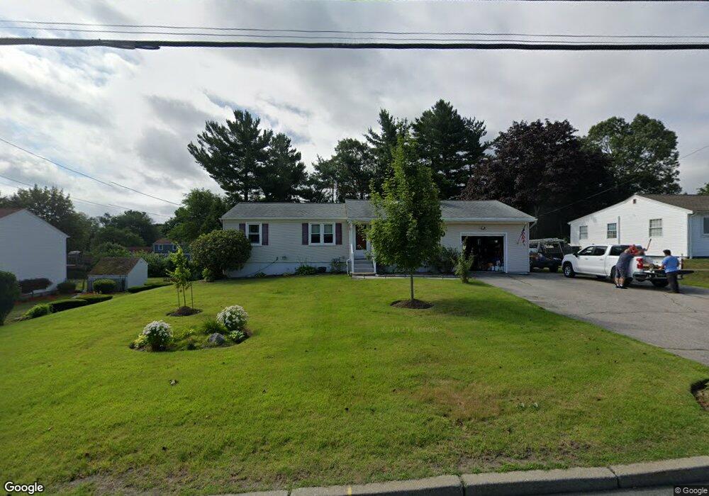
1194 Scituate Ave Cranston, RI 02921
Comstock Gardens NeighborhoodEstimated Value: $402,000 - $643,000
3
Beds
2
Baths
1,575
Sq Ft
$306/Sq Ft
Est. Value
About This Home
This home is located at 1194 Scituate Ave, Cranston, RI 02921 and is currently estimated at $481,179, approximately $305 per square foot. 1194 Scituate Ave is a home located in Providence County with nearby schools including Orchard Farms El. School, Western Hills Middle School, and Cranston High School West.
Ownership History
Date
Name
Owned For
Owner Type
Purchase Details
Closed on
May 24, 2001
Sold by
Darienzo Matthew B and Darienzo Barbara
Bought by
Horning Richard T and Horning Jennifer
Current Estimated Value
Home Financials for this Owner
Home Financials are based on the most recent Mortgage that was taken out on this home.
Original Mortgage
$157,700
Interest Rate
7.05%
Create a Home Valuation Report for This Property
The Home Valuation Report is an in-depth analysis detailing your home's value as well as a comparison with similar homes in the area
Home Values in the Area
Average Home Value in this Area
Purchase History
| Date | Buyer | Sale Price | Title Company |
|---|---|---|---|
| Horning Richard T | $166,000 | -- |
Source: Public Records
Mortgage History
| Date | Status | Borrower | Loan Amount |
|---|---|---|---|
| Closed | Horning Richard T | $128,250 | |
| Closed | Horning Richard T | $159,000 | |
| Closed | Horning Richard T | $157,700 | |
| Previous Owner | Horning Richard T | $118,000 |
Source: Public Records
Tax History
| Year | Tax Paid | Tax Assessment Tax Assessment Total Assessment is a certain percentage of the fair market value that is determined by local assessors to be the total taxable value of land and additions on the property. | Land | Improvement |
|---|---|---|---|---|
| 2025 | $5,387 | $388,100 | $131,700 | $256,400 |
| 2024 | $5,282 | $388,100 | $131,700 | $256,400 |
| 2023 | $4,954 | $262,100 | $86,700 | $175,400 |
| 2022 | $4,851 | $262,100 | $86,700 | $175,400 |
| 2021 | $4,718 | $262,100 | $86,700 | $175,400 |
| 2020 | $4,484 | $215,900 | $82,500 | $133,400 |
| 2019 | $4,484 | $215,900 | $82,500 | $133,400 |
| 2018 | $4,381 | $215,900 | $82,500 | $133,400 |
| 2017 | $4,313 | $188,000 | $74,300 | $113,700 |
| 2016 | $4,221 | $188,000 | $74,300 | $113,700 |
| 2015 | $4,221 | $188,000 | $74,300 | $113,700 |
| 2014 | $4,008 | $175,500 | $74,300 | $101,200 |
Source: Public Records
Map
Nearby Homes
- 9 Gray Coach Ln Unit 911
- 121 Ashbrook Dr
- 7 Taylor Rd
- 141 Fox Ridge Dr
- 2073 Plainfield Pike
- 20 Doreen Ct
- 1835 Plainfield Pike
- 02 Paula Ln
- 01 Paula Ln
- 25 Janet Dr
- 12 Beechwood Dr
- 1757 Plainfield Pike
- 95 Amy Dr
- 105 Amy Dr
- 0 Anthony Dr Unit 1394338
- 1495 Pippin Orchard Rd
- 72 Westfield Dr
- 27 Nardolillo St
- 154 Beechwood Dr
- 0 W Bluebird Ln
- 1184 Scituate Ave
- 1186 Scituate Ave
- 41 Nelson Rd
- 1225 Scituate Ave Unit 30
- 1225 Scituate Ave Unit 41
- 1225 Scituate Ave Unit 38
- 1225 Scituate Ave Unit 80
- 1225 Scituate Ave Unit 84
- 1196 Scituate Ave
- 49 Nelson Rd
- 1174 Scituate Ave
- 37 Nelson Rd
- 59 Nelson Rd
- 1226 Scituate Ave
- 1164 Scituate Ave
- 17 Nelson Rd
- 67 Nelson Rd
- 60 Ashburton Dr
- 64 Ashburton Dr
- 64 Ashburton Dr Unit 64
Your Personal Tour Guide
Ask me questions while you tour the home.