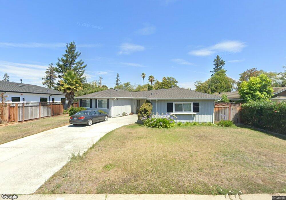
11992 Brookridge Dr Saratoga, CA 95070
West San Jose NeighborhoodEstimated Value: $3,059,949 - $3,588,000
5
Beds
2
Baths
1,402
Sq Ft
$2,341/Sq Ft
Est. Value
About This Home
This home is located at 11992 Brookridge Dr, Saratoga, CA 95070 and is currently estimated at $3,282,737, approximately $2,341 per square foot. 11992 Brookridge Dr is a home located in Santa Clara County with nearby schools including Country Lane Elementary School, Moreland Middle School, and Prospect High School.
Ownership History
Date
Name
Owned For
Owner Type
Purchase Details
Closed on
Mar 19, 2001
Sold by
Gray Michael E and Gray Mary Kay
Bought by
Gray Michael E and Gray Mary Kay
Current Estimated Value
Purchase Details
Closed on
Jul 14, 1995
Sold by
Zoranovich Alex J
Bought by
Gray Michael E and Gray Mary Kay
Create a Home Valuation Report for This Property
The Home Valuation Report is an in-depth analysis detailing your home's value as well as a comparison with similar homes in the area
Home Values in the Area
Average Home Value in this Area
Purchase History
| Date | Buyer | Sale Price | Title Company |
|---|---|---|---|
| Gray Michael E | -- | -- | |
| Gray Michael E | $365,000 | Old Republic Title |
Source: Public Records
Mortgage History
| Date | Status | Borrower | Loan Amount |
|---|---|---|---|
| Closed | Gray Michael E | -- |
Source: Public Records
Tax History Compared to Growth
Tax History
| Year | Tax Paid | Tax Assessment Tax Assessment Total Assessment is a certain percentage of the fair market value that is determined by local assessors to be the total taxable value of land and additions on the property. | Land | Improvement |
|---|---|---|---|---|
| 2025 | $9,415 | $689,162 | $303,170 | $385,992 |
| 2024 | $9,415 | $675,650 | $297,226 | $378,424 |
| 2023 | $9,242 | $662,403 | $291,399 | $371,004 |
| 2022 | $9,107 | $649,416 | $285,686 | $363,730 |
| 2021 | $8,960 | $636,684 | $280,085 | $356,599 |
| 2020 | $8,816 | $630,157 | $277,214 | $352,943 |
| 2019 | $8,470 | $617,802 | $271,779 | $346,023 |
| 2018 | $8,293 | $605,689 | $266,450 | $339,239 |
| 2017 | $8,169 | $593,814 | $261,226 | $332,588 |
| 2016 | $7,693 | $582,171 | $256,104 | $326,067 |
| 2015 | $7,600 | $573,428 | $252,258 | $321,170 |
| 2014 | $7,404 | $562,196 | $247,317 | $314,879 |
Source: Public Records
Map
Nearby Homes
- 12140 Woodside Dr
- 5635 W Walbrook Dr
- 1577 Maurice Ln
- 1587 Miller Ave
- 1681 Danromas Way
- 1367 Cordelia Ave
- 12584 Paseo Flores
- 5043 Le Miccine Terrace Unit 76
- 1092 Strayer Dr
- 19920 Viewridge Dr
- 1957 Colusa Way
- 11315 Cottonwood Place Unit 39-09 Plan 3
- 11210 Cottonwood Place Unit 35-08 Plan 4
- 6117 Brigantine Dr
- 11220 Cottonwood Place Unit 36-08 Plan 2
- Plan 2 at The Elms
- Plan 3 at The Elms
- Plan 4 at The Elms
- 11240 Cottonwood Place Unit 38-08 Plan 3
- 10750 Elm Cir Unit 88-17 Plan 2
- 12008 Brookridge Dr
- 12003 Brookglen Dr
- 12019 Brookglen Dr
- 11960 Brookridge Dr
- 12011 Brookridge Dr
- 12024 Brookridge Dr
- 11991 Brookridge Dr
- 11987 Brookglen Dr
- 11971 Brookridge Dr
- 11944 Brookridge Dr
- 19101 Brook Ln
- 11951 Brookridge Dr
- 19020 Brook Ln
- 11971 Brookglen Dr
- 19040 Brook Ln
- 12051 Brookglen Dr
- 19060 Brook Ln
- 19100 Brooknoll Ct
- 19125 Brook Ln
- 11928 Brookridge Dr