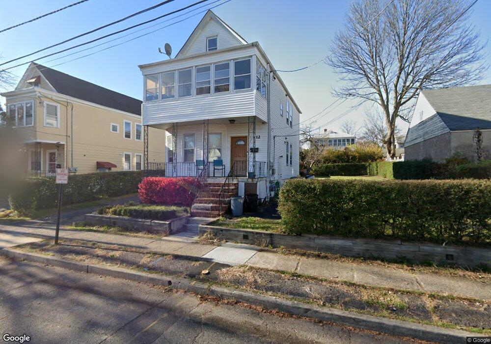
12 Adams St Clifton, NJ 07011
Hazel NeighborhoodEstimated Value: $455,000 - $646,000
Studio
--
Bath
1,516
Sq Ft
$375/Sq Ft
Est. Value
About This Home
This home is located at 12 Adams St, Clifton, NJ 07011 and is currently estimated at $567,928, approximately $374 per square foot. 12 Adams St is a home located in Passaic County with nearby schools including Clifton High School, Paterson Charter School for Science & Technology, and Njedda Elementary School.
Ownership History
Date
Name
Owned For
Owner Type
Purchase Details
Closed on
Aug 15, 2011
Sold by
Sedano Otto M
Bought by
Sedano Miguel
Current Estimated Value
Purchase Details
Closed on
Jan 18, 2011
Sold by
Hsbc Bank Usa
Bought by
Sedano Otto M
Purchase Details
Closed on
Dec 1, 2009
Sold by
Passaic County Sheriff and Quispe Victor
Bought by
Hsbc Bank Usa Na
Purchase Details
Closed on
Apr 25, 2006
Sold by
Zidan Ali
Bought by
Quispe Victor
Home Financials for this Owner
Home Financials are based on the most recent Mortgage that was taken out on this home.
Original Mortgage
$367,200
Interest Rate
7.95%
Mortgage Type
Adjustable Rate Mortgage/ARM
Purchase Details
Closed on
May 26, 2005
Sold by
Bari Debra S
Bought by
Zidan Ali
Create a Home Valuation Report for This Property
The Home Valuation Report is an in-depth analysis detailing your home's value as well as a comparison with similar homes in the area
Home Values in the Area
Average Home Value in this Area
Purchase History
We collect this data history from publicly available records. To have your information removed, we recommend requesting removal directly through your county’s website.
| Date | Buyer | Sale Price | Title Company |
|---|---|---|---|
| Sedano Miguel | -- | -- | |
| Sedano Otto M | $200,000 | -- | |
| Hsbc Bank Usa Na | $391,523 | -- | |
| Quispe Victor | $459,000 | -- | |
| Zidan Ali | $375,000 | -- |
Source: Public Records
Mortgage History
We collect this data history from publicly available records. To have your information removed, we recommend requesting removal directly through your county’s website.
| Date | Status | Borrower | Loan Amount |
|---|---|---|---|
| Previous Owner | Quispe Victor | $367,200 |
Source: Public Records
Tax History
| Year | Tax Paid | Tax Assessment Tax Assessment Total Assessment is a certain percentage of the fair market value that is determined by local assessors to be the total taxable value of land and additions on the property. | Land | Improvement |
|---|---|---|---|---|
| 2025 | $10,097 | $170,100 | $78,200 | $91,900 |
| 2024 | $9,856 | $170,100 | $78,200 | $91,900 |
| 2022 | $9,713 | $170,100 | $78,200 | $91,900 |
| 2021 | $9,313 | $170,100 | $78,200 | $91,900 |
| 2020 | $9,344 | $170,100 | $78,200 | $91,900 |
| 2019 | $9,277 | $170,100 | $78,200 | $91,900 |
| 2018 | $9,225 | $170,100 | $78,200 | $91,900 |
| 2017 | $9,124 | $170,100 | $78,200 | $91,900 |
| 2016 | $8,947 | $170,100 | $78,200 | $91,900 |
| 2015 | $8,861 | $170,100 | $78,200 | $91,900 |
| 2014 | $8,679 | $170,100 | $78,200 | $91,900 |
Source: Public Records
Map
Nearby Homes
- 11 Adams St
- 23 Prospect St
- 354 Dakota St
- 14 Dey St Unit 16
- 14-16 Dey St
- 82 Montclair Ave Unit 88
- 45 Dey St
- 88 Montclair Ave Unit 90
- 28 Buffalo Ave Unit 30
- 339 Paxton St
- 28 Butler St
- 311 Paxton St
- 73-75 Knickerbocker Ave
- 7 Montclair Ave
- 54 Bloomfield Ave Unit 56
- 88 Genessee Ave
- 69-71 Crooks Ave
- 126 Gould Ave
- 235 Dakota St Unit 1
- 235 Dakota St
Your Personal Tour Guide
Ask me questions while you tour the home.