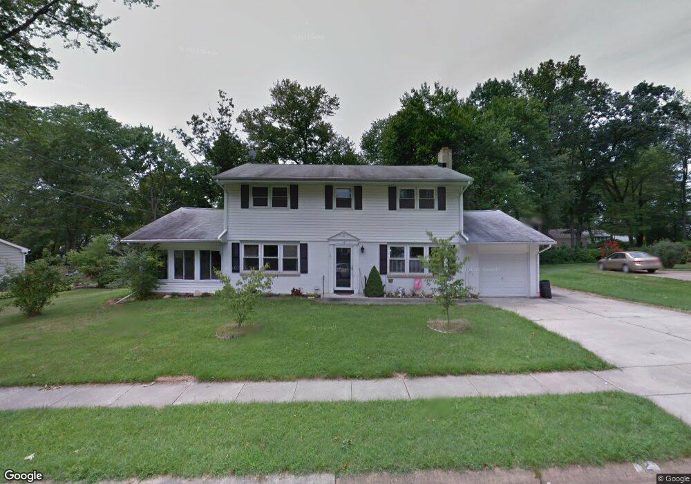
12 Amherst Dr Newark, DE 19711
Estimated Value: $494,000 - $545,000
5
Beds
3
Baths
2,796
Sq Ft
$187/Sq Ft
Est. Value
About This Home
This home is located at 12 Amherst Dr, Newark, DE 19711 and is currently estimated at $522,570, approximately $186 per square foot. 12 Amherst Dr is a home located in New Castle County with nearby schools including Downes (John R.) Elementary School, Shue-Medill Middle School, and Newark High School.
Ownership History
Date
Name
Owned For
Owner Type
Purchase Details
Closed on
Nov 12, 2004
Sold by
Stone Robert G and Stone Joan K
Bought by
Mccrumb Barbara J
Current Estimated Value
Home Financials for this Owner
Home Financials are based on the most recent Mortgage that was taken out on this home.
Original Mortgage
$252,000
Outstanding Balance
$125,924
Interest Rate
5.8%
Mortgage Type
Purchase Money Mortgage
Estimated Equity
$396,646
Create a Home Valuation Report for This Property
The Home Valuation Report is an in-depth analysis detailing your home's value as well as a comparison with similar homes in the area
Home Values in the Area
Average Home Value in this Area
Purchase History
| Date | Buyer | Sale Price | Title Company |
|---|---|---|---|
| Mccrumb Barbara J | $315,000 | -- |
Source: Public Records
Mortgage History
| Date | Status | Borrower | Loan Amount |
|---|---|---|---|
| Open | Mccrumb Barbara J | $252,000 | |
| Closed | Mccrumb Barbara J | $31,500 |
Source: Public Records
Tax History
| Year | Tax Paid | Tax Assessment Tax Assessment Total Assessment is a certain percentage of the fair market value that is determined by local assessors to be the total taxable value of land and additions on the property. | Land | Improvement |
|---|---|---|---|---|
| 2024 | $935 | $88,600 | $16,900 | $71,700 |
| 2023 | $3,204 | $88,600 | $16,900 | $71,700 |
| 2022 | $3,170 | $88,600 | $16,900 | $71,700 |
| 2021 | $3,088 | $88,600 | $16,900 | $71,700 |
| 2020 | $3,000 | $88,600 | $16,900 | $71,700 |
| 2019 | $2,629 | $88,600 | $16,900 | $71,700 |
| 2018 | $2,569 | $88,600 | $16,900 | $71,700 |
| 2017 | $2,492 | $88,600 | $16,900 | $71,700 |
| 2016 | $2,485 | $88,600 | $16,900 | $71,700 |
| 2015 | -- | $88,600 | $16,900 | $71,700 |
| 2014 | $2,227 | $88,600 | $16,900 | $71,700 |
Source: Public Records
Map
Nearby Homes
- 914 Quail Ln
- 105 Tanglewood Ln
- 102 Joshua (6 Building Lots) Ln
- 2 Leahy Dr
- 104 Country Club Dr
- 104 Leahy Dr
- 506 Cambridge Dr
- 3 Leahy Dr
- 0001 Leahy Dr
- 180 Madison Dr
- 30 Julie Ln
- 405 Leahy Dr
- 402 Leahy Dr
- 406 Leahy Dr
- 153 King William St Unit 153
- 311 Stamford Dr
- 158 Kirkcaldy Dr
- 117 W Shetland Ct
- 6 Haywood Ct
- 47 Covered Bridge Ln
Your Personal Tour Guide
Ask me questions while you tour the home.