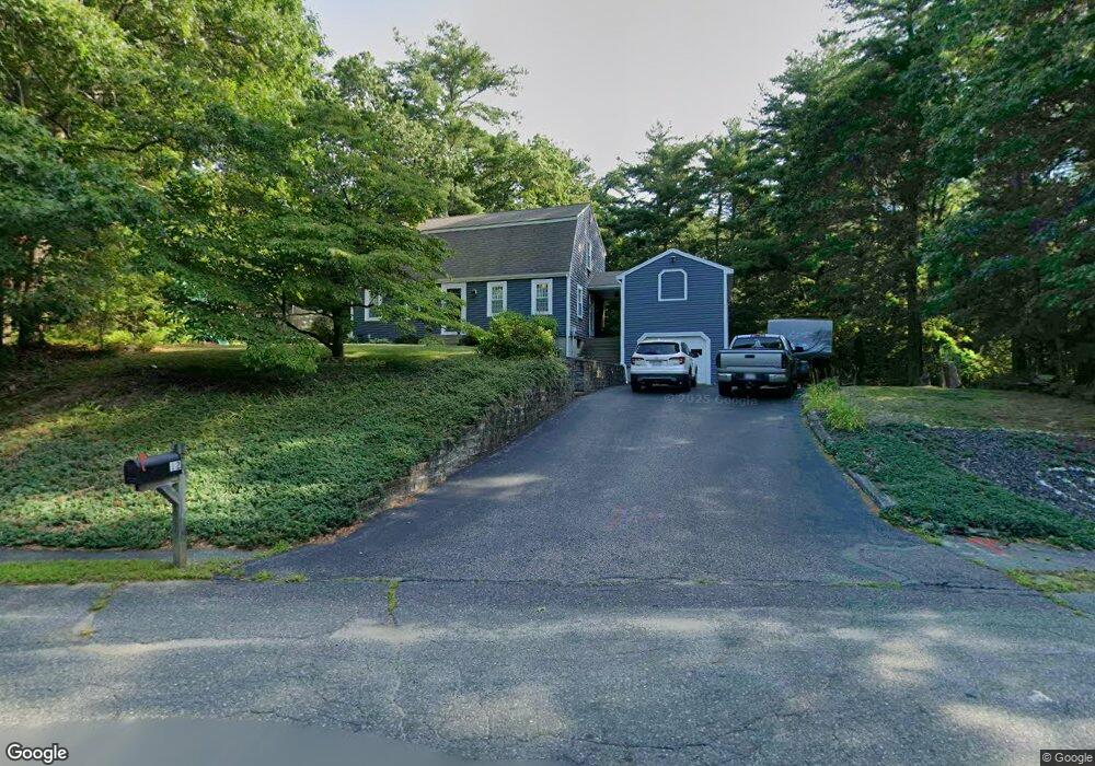
12 Benjamins Path Pembroke, MA 02359
Estimated Value: $678,760 - $775,000
3
Beds
2
Baths
1,642
Sq Ft
$453/Sq Ft
Est. Value
About This Home
This home is located at 12 Benjamins Path, Pembroke, MA 02359 and is currently estimated at $744,440, approximately $453 per square foot. 12 Benjamins Path is a home located in Plymouth County with nearby schools including Pembroke High School, Cadence Academy Preschool - Hanover, and Cardinal Cushing Centers.
Ownership History
Date
Name
Owned For
Owner Type
Purchase Details
Closed on
Jun 27, 2017
Sold by
Delano Steven A and Delano Kathleen
Bought by
Weir Daniel J and Weir Michelle C
Current Estimated Value
Home Financials for this Owner
Home Financials are based on the most recent Mortgage that was taken out on this home.
Original Mortgage
$360,000
Outstanding Balance
$300,406
Interest Rate
4.05%
Mortgage Type
New Conventional
Estimated Equity
$444,034
Purchase Details
Closed on
Oct 14, 1983
Bought by
Delano Steven A and Delano Kathleen
Create a Home Valuation Report for This Property
The Home Valuation Report is an in-depth analysis detailing your home's value as well as a comparison with similar homes in the area
Home Values in the Area
Average Home Value in this Area
Purchase History
| Date | Buyer | Sale Price | Title Company |
|---|---|---|---|
| Weir Daniel J | $450,000 | -- | |
| Delano Steven A | $92,900 | -- |
Source: Public Records
Mortgage History
| Date | Status | Borrower | Loan Amount |
|---|---|---|---|
| Open | Weir Daniel J | $360,000 | |
| Previous Owner | Delano Steven A | $20,000 | |
| Previous Owner | Delano Steven A | $65,000 | |
| Previous Owner | Delano Steven A | $75,000 |
Source: Public Records
Tax History
| Year | Tax Paid | Tax Assessment Tax Assessment Total Assessment is a certain percentage of the fair market value that is determined by local assessors to be the total taxable value of land and additions on the property. | Land | Improvement |
|---|---|---|---|---|
| 2025 | $7,363 | $612,600 | $325,500 | $287,100 |
| 2024 | $7,003 | $582,100 | $320,300 | $261,800 |
| 2023 | $6,929 | $544,700 | $295,500 | $249,200 |
| 2022 | $6,479 | $457,900 | $235,500 | $222,400 |
| 2021 | $6,475 | $444,100 | $230,300 | $213,800 |
| 2020 | $6,312 | $435,600 | $230,300 | $205,300 |
| 2019 | $6,136 | $420,300 | $220,200 | $200,100 |
| 2018 | $6,027 | $404,800 | $220,200 | $184,600 |
| 2017 | $5,901 | $390,800 | $205,400 | $185,400 |
| 2016 | $5,808 | $380,600 | $195,400 | $185,200 |
| 2015 | $6,200 | $420,600 | $185,400 | $235,200 |
Source: Public Records
Map
Nearby Homes
- 31 Hillcrest Dr
- 8 Quaker Cir
- 58 Bagnell Dr Unit 58
- 593 Washington St Unit A
- 22 Barker Square Dr Unit 22
- 269 Washington St Unit A1
- 261 Washington St
- 26 Blake Ave
- 6 Hillside Ln
- 5 Royal Dane Dr Unit 45
- 10 Royal Dane Dr Unit 85
- 99 Old Washington St
- 615 Keene St
- 451 School St Unit 2-5
- 451 School St Unit 5-2
- 848 Plain St Unit 41
- 848 Plain St Unit 23
- 172 Washington St
- 2 Proprietors Dr Unit 25
- 2 Proprietors Dr Unit 26
Your Personal Tour Guide
Ask me questions while you tour the home.