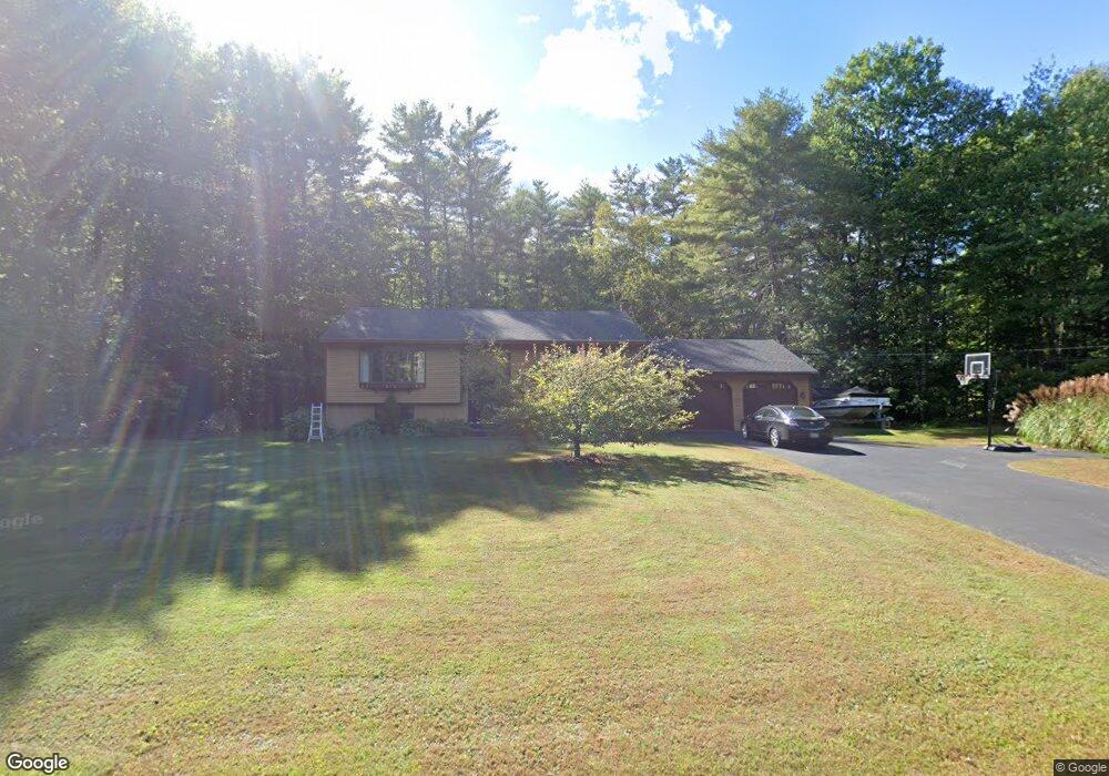
12 Black Point Rd New Gloucester, ME 04260
Estimated Value: $479,483 - $599,000
3
Beds
2
Baths
2,501
Sq Ft
$208/Sq Ft
Est. Value
About This Home
This home is located at 12 Black Point Rd, New Gloucester, ME 04260 and is currently estimated at $519,871, approximately $207 per square foot. 12 Black Point Rd is a home located in Cumberland County with nearby schools including Gray-New Gloucester High School.
Ownership History
Date
Name
Owned For
Owner Type
Purchase Details
Closed on
Dec 21, 2020
Sold by
Plummer Shannon
Bought by
Plummer Nathan
Current Estimated Value
Home Financials for this Owner
Home Financials are based on the most recent Mortgage that was taken out on this home.
Original Mortgage
$248,000
Outstanding Balance
$220,181
Interest Rate
2.8%
Mortgage Type
New Conventional
Estimated Equity
$299,690
Purchase Details
Closed on
Jul 1, 2009
Sold by
Swanson Carol J
Bought by
Plummer Nathan A and Lundin Shannon E
Home Financials for this Owner
Home Financials are based on the most recent Mortgage that was taken out on this home.
Original Mortgage
$216,015
Interest Rate
4.86%
Mortgage Type
FHA
Create a Home Valuation Report for This Property
The Home Valuation Report is an in-depth analysis detailing your home's value as well as a comparison with similar homes in the area
Home Values in the Area
Average Home Value in this Area
Purchase History
| Date | Buyer | Sale Price | Title Company |
|---|---|---|---|
| Plummer Nathan | -- | None Available | |
| Plummer Nathan A | -- | -- |
Source: Public Records
Mortgage History
| Date | Status | Borrower | Loan Amount |
|---|---|---|---|
| Open | Plummer Nathan | $248,000 | |
| Previous Owner | Plummer Nathan A | $216,015 |
Source: Public Records
Tax History
| Year | Tax Paid | Tax Assessment Tax Assessment Total Assessment is a certain percentage of the fair market value that is determined by local assessors to be the total taxable value of land and additions on the property. | Land | Improvement |
|---|---|---|---|---|
| 2025 | $3,639 | $235,198 | $81,960 | $153,238 |
| 2024 | $3,502 | $235,198 | $81,960 | $153,238 |
| 2023 | $3,361 | $235,198 | $81,960 | $153,238 |
| 2022 | $3,246 | $235,198 | $81,960 | $153,238 |
| 2021 | $3,246 | $235,198 | $81,960 | $153,238 |
| 2020 | $3,210 | $235,198 | $81,960 | $153,238 |
| 2019 | $3,747 | $221,700 | $66,300 | $155,400 |
| 2018 | $3,503 | $221,700 | $66,300 | $155,400 |
| 2017 | $3,459 | $221,700 | $66,300 | $155,400 |
| 2016 | $3,259 | $221,700 | $66,300 | $155,400 |
| 2015 | $3,248 | $221,700 | $66,300 | $155,400 |
| 2014 | $3,215 | $221,700 | $66,300 | $155,400 |
| 2013 | $2,982 | $221,700 | $66,300 | $155,400 |
Source: Public Records
Map
Nearby Homes
- 14 Golden Way
- 226 Sabbathday Rd
- TBD Emmaus Rd
- TBD Targett Rd
- 2 Alling Dr
- 65 Blueberry Ln
- 110 Bennett Rd
- 00 N Shore Rd
- 86 Skips Way
- 97 N Raymond Rd
- 155 & 151 Gloucester Hill Rd
- 173 Weymouth Rd
- 4 Chelsey Ln
- 194 Weymouth Rd
- 15 May Meadow Dr
- 163 Valley Rd
- 72 Shaw Brook Ln
- 46-47D Hines Rd & Main St
- Lot 47C Hines Rd
- 10 Evelyn's Way
- 813 Snow Hill Rd
- 28 Black Point Rd
- 33 Black Point Rd
- 35 Black Point Rd
- 170 Black Point Rd
- 184 Black Point Rd
- 45 Black Point Rd
- 129 Sunset Shores Rd
- 769 Snow Hill Rd
- 53 Black Point Rd
- 624 Bennett Rd
- 125 Sunset Shores Rd
- 99 Black Point Rd
- 167 Black Point Rd
- 107 Black Point Rd
- 113 Black Point Rd
- 89 Black Point Rd
- 63 Black Point Rd
- 121 Black Point Rd
- 851 Snow Hill Rd
Your Personal Tour Guide
Ask me questions while you tour the home.