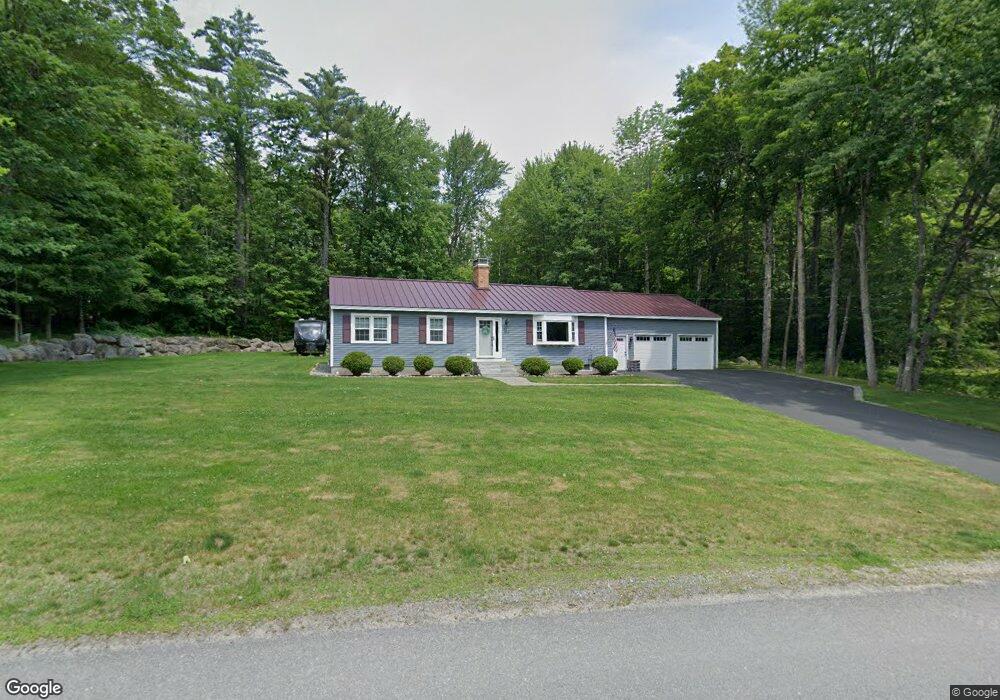
12 Boulder Rd Hillsborough, NH 03244
Hillsboro NeighborhoodEstimated Value: $429,000 - $464,000
3
Beds
2
Baths
1,955
Sq Ft
$228/Sq Ft
Est. Value
About This Home
This home is located at 12 Boulder Rd, Hillsborough, NH 03244 and is currently estimated at $446,254, approximately $228 per square foot. 12 Boulder Rd is a home located in Hillsborough County with nearby schools including Hillsboro-Deering Elementary School, Hillsboro-Deering High School, and Hillsboro Christian School.
Ownership History
Date
Name
Owned For
Owner Type
Purchase Details
Closed on
Mar 25, 2004
Sold by
Goss Richard I and Goss Michelle M
Bought by
Larochelle Guy M and Larochelle Catherine L
Current Estimated Value
Create a Home Valuation Report for This Property
The Home Valuation Report is an in-depth analysis detailing your home's value as well as a comparison with similar homes in the area
Home Values in the Area
Average Home Value in this Area
Purchase History
| Date | Buyer | Sale Price | Title Company |
|---|---|---|---|
| Larochelle Guy M | $174,000 | -- |
Source: Public Records
Mortgage History
| Date | Status | Borrower | Loan Amount |
|---|---|---|---|
| Open | Larochelle Guy M | $182,499 | |
| Closed | Larochelle Guy M | $190,812 | |
| Closed | Larochelle Guy M | $20,000 |
Source: Public Records
Tax History Compared to Growth
Tax History
| Year | Tax Paid | Tax Assessment Tax Assessment Total Assessment is a certain percentage of the fair market value that is determined by local assessors to be the total taxable value of land and additions on the property. | Land | Improvement |
|---|---|---|---|---|
| 2024 | $6,681 | $199,800 | $39,200 | $160,600 |
| 2023 | $6,238 | $199,800 | $39,200 | $160,600 |
| 2022 | $5,333 | $199,800 | $39,200 | $160,600 |
| 2021 | $5,608 | $193,900 | $39,200 | $154,700 |
| 2020 | $5,571 | $193,900 | $39,200 | $154,700 |
| 2018 | $5,027 | $170,400 | $28,600 | $141,800 |
| 2017 | $5,192 | $170,400 | $28,600 | $141,800 |
| 2016 | $4,918 | $166,600 | $30,600 | $136,000 |
| 2015 | $4,840 | $166,600 | $30,600 | $136,000 |
| 2014 | $4,591 | $166,600 | $30,600 | $136,000 |
| 2013 | $4,675 | $166,600 | $30,600 | $136,000 |
Source: Public Records
Map
Nearby Homes
- 0 W Main St Unit 1
- Lot 14 Old Mill Farm Rd
- 0 Route 202 Route Unit 4983445
- 31 Woodlawn Ave
- 23 Pleasant St
- 237 2nd New Hampshire Turnpike
- 31 Central St Unit G
- 20-22 Church St
- 73 W Main St
- 1 W Main St
- 88 W Mill St
- 0 Center Rd
- 45 Keyes Farm Rd
- 9 Wyman Rd
- 5 Chamberlain Ct Unit 56
- 21 Wyman Rd
- 298 2nd New Hampshire Turnpike Unit 10-038-000
- 298 2nd New Hampshire Turnpike
- 32 Union St
- 447 Center Rd
- 18 Boulder Rd
- 11 Boulder Rd
- 4 Boulder Rd
- 107 Bible Hill Rd
- 121 Bible Hill Rd
- 135 Bible Hill Rd
- 22 Boulder Rd
- 00 Confidential
- 104 Bible Hill Rd
- 0 Boulder Rd
- 101 Bible Hill Rd
- 100 Bible Hill Rd
- 23 Boulder Rd
- 28 Boulder Rd
- 36 Symonds Rd
- 110 Bible Hill Rd
- 27 Boulder Rd
- 32 Symonds Rd
- 120 Bible Hill Rd
- 28 Symonds Rd