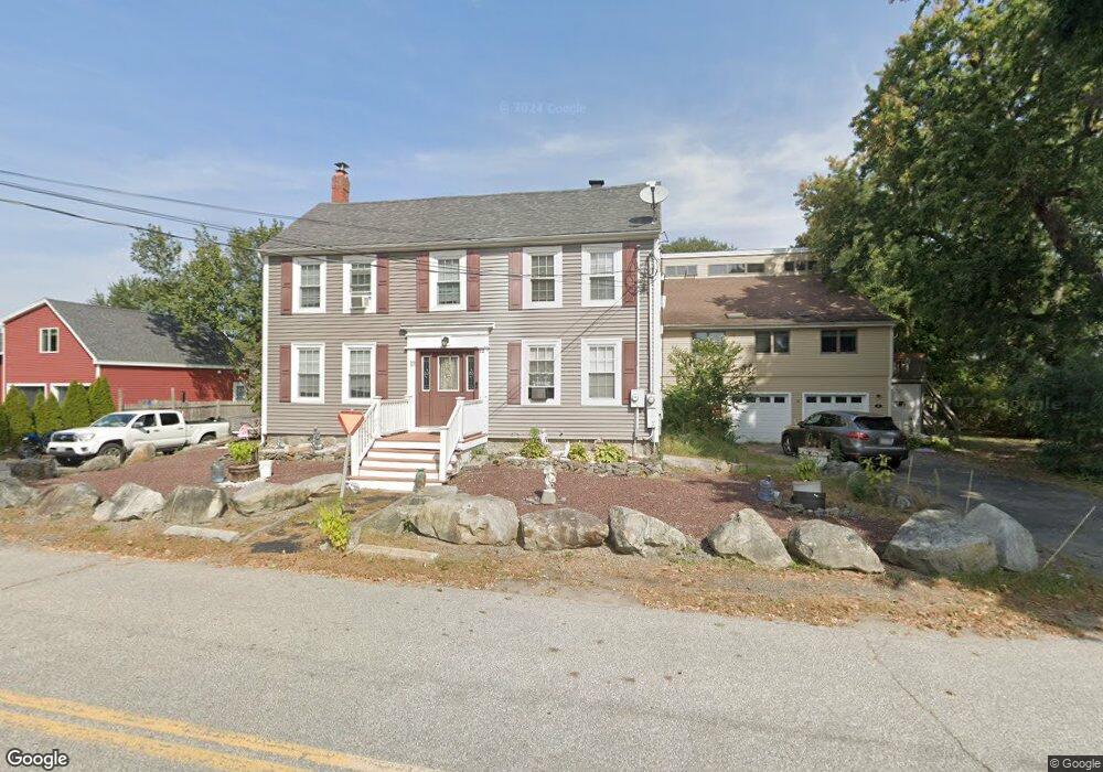
12 Dearborne Ave Seabrook, NH 03874
Estimated Value: $497,000 - $680,000
3
Beds
3
Baths
2,120
Sq Ft
$271/Sq Ft
Est. Value
About This Home
This home is located at 12 Dearborne Ave, Seabrook, NH 03874 and is currently estimated at $573,475, approximately $270 per square foot. 12 Dearborne Ave is a home located in Rockingham County with nearby schools including Seabrook Elementary School, Seabrook Middle School, and Winnacunnet High School.
Ownership History
Date
Name
Owned For
Owner Type
Purchase Details
Closed on
Jun 12, 2017
Sold by
Rosa Mary L
Bought by
Mary L Rosa Ret and Rosa
Current Estimated Value
Purchase Details
Closed on
Nov 5, 2010
Sold by
Fhlmc
Bought by
Rosa Charles A
Purchase Details
Closed on
Mar 29, 2010
Sold by
Forcier Lori A and Forcier Fhlmc
Bought by
Fhlmc
Create a Home Valuation Report for This Property
The Home Valuation Report is an in-depth analysis detailing your home's value as well as a comparison with similar homes in the area
Home Values in the Area
Average Home Value in this Area
Purchase History
| Date | Buyer | Sale Price | Title Company |
|---|---|---|---|
| Mary L Rosa Ret | -- | -- | |
| Rosa Mary L | -- | -- | |
| Rosa Charles A | $40,800 | -- | |
| Fhlmc | $155,000 | -- |
Source: Public Records
Mortgage History
| Date | Status | Borrower | Loan Amount |
|---|---|---|---|
| Previous Owner | Fhlmc | $149,772 |
Source: Public Records
Tax History Compared to Growth
Tax History
| Year | Tax Paid | Tax Assessment Tax Assessment Total Assessment is a certain percentage of the fair market value that is determined by local assessors to be the total taxable value of land and additions on the property. | Land | Improvement |
|---|---|---|---|---|
| 2024 | $4,778 | $407,700 | $182,700 | $225,000 |
| 2023 | $5,230 | $346,600 | $148,800 | $197,800 |
| 2022 | $4,592 | $346,600 | $148,800 | $197,800 |
| 2021 | $4,573 | $333,100 | $135,300 | $197,800 |
| 2020 | $4,277 | $265,600 | $108,200 | $157,400 |
| 2019 | $251 | $265,600 | $108,200 | $157,400 |
| 2018 | $4,170 | $256,600 | $99,200 | $157,400 |
| 2017 | $263 | $240,000 | $82,600 | $157,400 |
| 2016 | $3,529 | $238,600 | $82,600 | $156,000 |
| 2015 | $3,010 | $203,500 | $77,200 | $126,300 |
| 2014 | $3,107 | $203,500 | $77,200 | $126,300 |
| 2013 | $3,107 | $203,500 | $77,200 | $126,300 |
Source: Public Records
Map
Nearby Homes
- 38 Rocks Rd Unit 2
- 38 Rocks Rd Unit 1
- 46 Kensington Rd
- 47 Scott Ave
- 81 Elm Ct
- 20 Railroad Ave
- 213 New Hampshire 107
- 51 Depot Rd
- 22 Farm Ln
- 8 Kimberly Dr
- 17 Drinkwater Rd
- 1 Lakeshore Dr
- 14 Coleman Ct
- 106 Folly Mill Rd
- 75 Border Winds Ave
- 22 Maple Ridge Rd
- 61 Folly Mill Rd
- 28 Brooks Rd
- 241 & 245 Lafayette Rd
- 57 Washington St
- 12 Dearborne Ave Unit 1
- 14 Dearborne Ave
- 855 Lafayette Rd
- 12 Dearborn Ave
- 867 Lafayette Rd
- 845 Lafayette Rd
- 28 Dearborn Ave
- 28 Dearborne Ave
- 875 Lafayette Rd
- 875 Lafayette Rd Unit A
- 30 Dearborne Ave
- 34 Dearborne Ave
- 922 Lafayette Rd Unit 102
- 922 Lafayette Rd
- 922 Lafayette Rd Unit 103
- 922 Lafayette Rd Unit 104
- 935 Lafayette Rd
- 31 Dearborne Ave
- 51 Gove Rd
- 823 Lafayette Rd